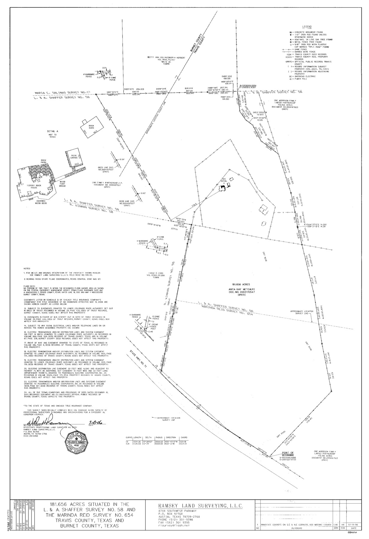
Travis County State Real Property Sketch 13
Field Notes and Sketch of a Survey of 181.656 Acres Situated in the L. and A. Shaffer Survey No. 58 and the Marinda Reid Survey No. 654
-
Map/Doc
88620
-
Collection
General Map Collection
-
Object Dates
2006/7/14 (Creation Date)
-
People and Organizations
Ramsey Land Surveying, L.L.C. (Publisher)
Ramsey Land Surveying, L.L.C. (Printer)
CAR (Draftsman)
William H. Ramsey (Surveyor/Engineer)
-
Counties
Travis Burnet
-
Subjects
State Real Property
-
Height x Width
35.3 x 24.1 inches
89.7 x 61.2 cm
-
Comments
Surveys located about 25 miles North 65 degrees West of Austin, Texas.
Part of: General Map Collection
Comanche County Sketch File 27

Print $22.00
- Digital $50.00
Comanche County Sketch File 27
1912
Size 9.4 x 7.1 inches
Map/Doc 19116
Flight Mission No. BRA-8M, Frame 74, Jefferson County

Print $20.00
- Digital $50.00
Flight Mission No. BRA-8M, Frame 74, Jefferson County
1953
Size 18.6 x 22.2 inches
Map/Doc 85594
Aransas County Rolled Sketch 19C

Print $20.00
- Digital $50.00
Aransas County Rolled Sketch 19C
Size 40.9 x 30.6 inches
Map/Doc 5063
El Paso County Working Sketch 29

Print $40.00
- Digital $50.00
El Paso County Working Sketch 29
1967
Size 43.0 x 64.8 inches
Map/Doc 69051
Presidio County Sketch File 73

Print $11.00
- Digital $50.00
Presidio County Sketch File 73
1944
Size 11.4 x 8.8 inches
Map/Doc 34682
Rockport Quadrangle

Print $20.00
- Digital $50.00
Rockport Quadrangle
1954
Size 21.3 x 18.3 inches
Map/Doc 73435
Eastland County Working Sketch 7

Print $3.00
- Digital $50.00
Eastland County Working Sketch 7
1918
Size 15.6 x 10.7 inches
Map/Doc 68788
Taylor County Sketch File 22

Print $189.00
- Digital $50.00
Taylor County Sketch File 22
1985
Size 14.6 x 8.9 inches
Map/Doc 37826
Haskell County Working Sketch 1

Print $40.00
- Digital $50.00
Haskell County Working Sketch 1
Size 31.0 x 74.5 inches
Map/Doc 66059
Wood County Rolled Sketch 3

Print $20.00
- Digital $50.00
Wood County Rolled Sketch 3
1941
Size 35.2 x 30.8 inches
Map/Doc 8282
Milam County Rolled Sketch 5A

Print $20.00
- Digital $50.00
Milam County Rolled Sketch 5A
1997
Size 28.0 x 39.8 inches
Map/Doc 6778
Kerr County Boundary File 5

Print $8.00
- Digital $50.00
Kerr County Boundary File 5
Size 14.2 x 8.7 inches
Map/Doc 64818
You may also like
Presidio County Rolled Sketch 82

Print $20.00
- Digital $50.00
Presidio County Rolled Sketch 82
1943
Size 35.5 x 26.1 inches
Map/Doc 7369
Cameron County Rolled Sketch 23

Print $17.00
- Digital $50.00
Cameron County Rolled Sketch 23
Size 10.0 x 15.2 inches
Map/Doc 43931
[F. W. & D. C. Ry. Co. Alignment and Right of Way Map, Clay County]
![64724, [F. W. & D. C. Ry. Co. Alignment and Right of Way Map, Clay County], General Map Collection](https://historictexasmaps.com/wmedia_w700/maps/64724-1.tif.jpg)
Print $20.00
- Digital $50.00
[F. W. & D. C. Ry. Co. Alignment and Right of Way Map, Clay County]
1927
Size 18.5 x 11.7 inches
Map/Doc 64724
Matagorda County Sketch File 42b

Print $12.00
- Digital $50.00
Matagorda County Sketch File 42b
1913
Size 11.2 x 8.7 inches
Map/Doc 30862
Intracoastal Waterway in Texas - Corpus Christi to Point Isabel including Arroyo Colorado to Mo. Pac. R.R. Bridge Near Harlingen

Print $20.00
- Digital $50.00
Intracoastal Waterway in Texas - Corpus Christi to Point Isabel including Arroyo Colorado to Mo. Pac. R.R. Bridge Near Harlingen
1933
Size 28.1 x 41.2 inches
Map/Doc 61845
Real County Working Sketch 72

Print $20.00
- Digital $50.00
Real County Working Sketch 72
1976
Size 47.3 x 43.3 inches
Map/Doc 71964
Fractional Township No. 7 South Range No. 20 East of the Indian Meridian, Indian Territory

Print $20.00
- Digital $50.00
Fractional Township No. 7 South Range No. 20 East of the Indian Meridian, Indian Territory
1897
Size 19.2 x 24.2 inches
Map/Doc 75236
Trinity River, Carl Switch Sheet/Chambers Creek

Print $4.00
- Digital $50.00
Trinity River, Carl Switch Sheet/Chambers Creek
1926
Size 27.9 x 27.0 inches
Map/Doc 65217
Crosby County Working Sketch 10

Print $20.00
- Digital $50.00
Crosby County Working Sketch 10
1946
Size 44.5 x 23.7 inches
Map/Doc 68444
Borden County Working Sketch 13

Print $20.00
- Digital $50.00
Borden County Working Sketch 13
1958
Size 24.1 x 35.6 inches
Map/Doc 67473
[Map of Texas and Pacific Blocks from Brazos River westward through Palo Pinto, Stephens, Shackelford, Jones, Callahan, Taylor, Fisher, Nolan and Mitchell Counties]
![93460, [Map of Texas and Pacific Blocks from Brazos River westward through Palo Pinto, Stephens, Shackelford, Jones, Callahan, Taylor, Fisher, Nolan and Mitchell Counties], General Map Collection](https://historictexasmaps.com/wmedia_w700/maps/93460.tif.jpg)
Print $40.00
- Digital $50.00
[Map of Texas and Pacific Blocks from Brazos River westward through Palo Pinto, Stephens, Shackelford, Jones, Callahan, Taylor, Fisher, Nolan and Mitchell Counties]
Size 87.1 x 18.8 inches
Map/Doc 93460
Bandera County Working Sketch 16c

Print $20.00
- Digital $50.00
Bandera County Working Sketch 16c
1942
Size 18.2 x 22.0 inches
Map/Doc 67611