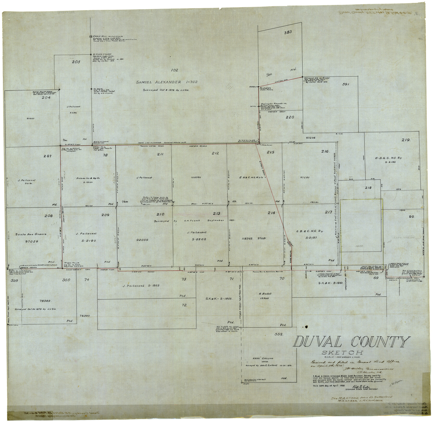
Duval County Rolled Sketch E
Duval County Sketch
-
Map/Doc
8808
-
Collection
General Map Collection
-
Object Dates
4/10/1935 (Creation Date)
4/11/1935 (File Date)
-
People and Organizations
Robt. E. Estes (Surveyor/Engineer)
-
Counties
Duval
-
Subjects
Surveying Rolled Sketch
-
Height x Width
36.4 x 37.7 inches
92.5 x 95.8 cm
-
Medium
linen, manuscript
-
Scale
1" = 400 varas
-
Comments
See Duval County Sketch File 85 (21534) for report and correspondence.
Related maps
Duval County Sketch File 85

Print $27.00
- Digital $50.00
Duval County Sketch File 85
1935
Size 14.3 x 9.1 inches
Map/Doc 21534
Part of: General Map Collection
Limestone County Sketch File 11

Print $4.00
- Digital $50.00
Limestone County Sketch File 11
1881
Size 7.9 x 9.5 inches
Map/Doc 30177
Travis County Sketch File 9

Print $4.00
- Digital $50.00
Travis County Sketch File 9
Size 12.6 x 8.2 inches
Map/Doc 38290
Flight Mission No. DQN-5K, Frame 24, Calhoun County

Print $20.00
- Digital $50.00
Flight Mission No. DQN-5K, Frame 24, Calhoun County
1953
Size 18.5 x 22.1 inches
Map/Doc 84375
Cottle County Sketch File 1

Print $20.00
- Digital $50.00
Cottle County Sketch File 1
1882
Size 20.7 x 18.9 inches
Map/Doc 11189

Copy of connection made by E. Sewell

Print $2.00
- Digital $50.00
Copy of connection made by E. Sewell
1841
Size 9.4 x 9.0 inches
Map/Doc 161
Mason County Sketch File 6

Print $4.00
- Digital $50.00
Mason County Sketch File 6
1875
Size 8.8 x 14.5 inches
Map/Doc 30687
Bandera County Boundary File 7

Print $14.00
- Digital $50.00
Bandera County Boundary File 7
Size 12.7 x 8.1 inches
Map/Doc 50306
Sherman County Sketch File A

Print $4.00
- Digital $50.00
Sherman County Sketch File A
1917
Size 11.2 x 8.8 inches
Map/Doc 44250
Floyd County Sketch File 33

Print $4.00
- Digital $50.00
Floyd County Sketch File 33
1953
Size 11.4 x 9.0 inches
Map/Doc 22796
Blanco County Working Sketch 20

Print $20.00
- Digital $50.00
Blanco County Working Sketch 20
1960
Size 27.3 x 36.4 inches
Map/Doc 67380
Nueces County Sketch File 28

Print $6.00
- Digital $50.00
Nueces County Sketch File 28
Size 10.0 x 10.9 inches
Map/Doc 32596
You may also like
Webb County Rolled Sketch 64

Print $20.00
- Digital $50.00
Webb County Rolled Sketch 64
1948
Size 42.0 x 27.3 inches
Map/Doc 8213
Flight Mission No. DQN-1K, Frame 116, Calhoun County

Print $20.00
- Digital $50.00
Flight Mission No. DQN-1K, Frame 116, Calhoun County
1953
Size 18.7 x 22.4 inches
Map/Doc 84182
Val Verde County Working Sketch 108

Print $20.00
- Digital $50.00
Val Verde County Working Sketch 108
1988
Size 31.1 x 41.3 inches
Map/Doc 72243
Steele Addition, Seagraves, Texas

Print $20.00
- Digital $50.00
Steele Addition, Seagraves, Texas
Size 17.4 x 26.3 inches
Map/Doc 92655
Coleman County Sketch File 15

Print $4.00
- Digital $50.00
Coleman County Sketch File 15
1848
Size 7.3 x 13.0 inches
Map/Doc 18681
[Sketch for Mineral Application 27670 - Strip between Simon Sanchez leagues and Trinity River]
![2865, [Sketch for Mineral Application 27670 - Strip between Simon Sanchez leagues and Trinity River], General Map Collection](https://historictexasmaps.com/wmedia_w700/maps/2865-1.tif.jpg)
Print $40.00
- Digital $50.00
[Sketch for Mineral Application 27670 - Strip between Simon Sanchez leagues and Trinity River]
1934
Size 17.3 x 50.5 inches
Map/Doc 2865
San Jacinto County Rolled Sketch 14

Print $20.00
- Digital $50.00
San Jacinto County Rolled Sketch 14
1998
Size 29.0 x 40.6 inches
Map/Doc 7567
Carte Générale du Royaume de la Nouvelle Espagne depuis le Parallele de 16° jusqu'au Parallele de 38° (Latitude Nord) dressée sur des Observations Astronomiques et sur l'ensemble des Matériaux qui existoient à Mexico, au commencement de l'année 1804

Print $20.00
- Digital $50.00
Carte Générale du Royaume de la Nouvelle Espagne depuis le Parallele de 16° jusqu'au Parallele de 38° (Latitude Nord) dressée sur des Observations Astronomiques et sur l'ensemble des Matériaux qui existoient à Mexico, au commencement de l'année 1804
1809
Size 21.7 x 32.9 inches
Map/Doc 93781
Howard County Rolled Sketch 5

Print $20.00
- Digital $50.00
Howard County Rolled Sketch 5
Size 19.6 x 16.5 inches
Map/Doc 6234
Crockett County Working Sketch 84

Print $40.00
- Digital $50.00
Crockett County Working Sketch 84
1976
Size 49.4 x 26.2 inches
Map/Doc 68417
Jasper County Texas

Print $20.00
- Digital $50.00
Jasper County Texas
1879
Size 31.5 x 18.2 inches
Map/Doc 3716
Gillespie County, Texas

Print $20.00
- Digital $50.00
Gillespie County, Texas
1879
Size 21.2 x 26.9 inches
Map/Doc 547