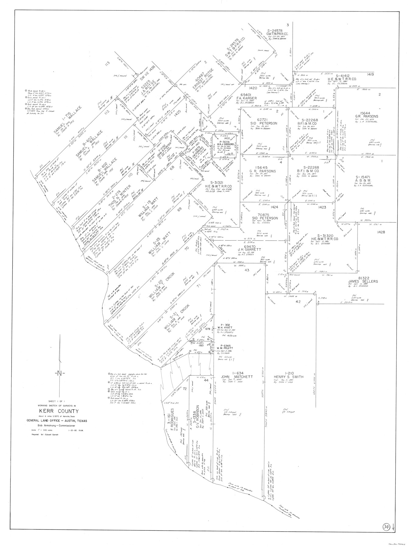
Kerr County Working Sketch 34
-
Map/Doc
70065
-
Collection
General Map Collection
-
Object Dates
1/22/1980 (Creation Date)
-
People and Organizations
Rosendo V. Molina (Draftsman)
-
Counties
Kerr
-
Subjects
Surveying Working Sketch
-
Height x Width
51.6 x 38.9 inches
131.1 x 98.8 cm
-
Scale
1" = 300 varas
Part of: General Map Collection
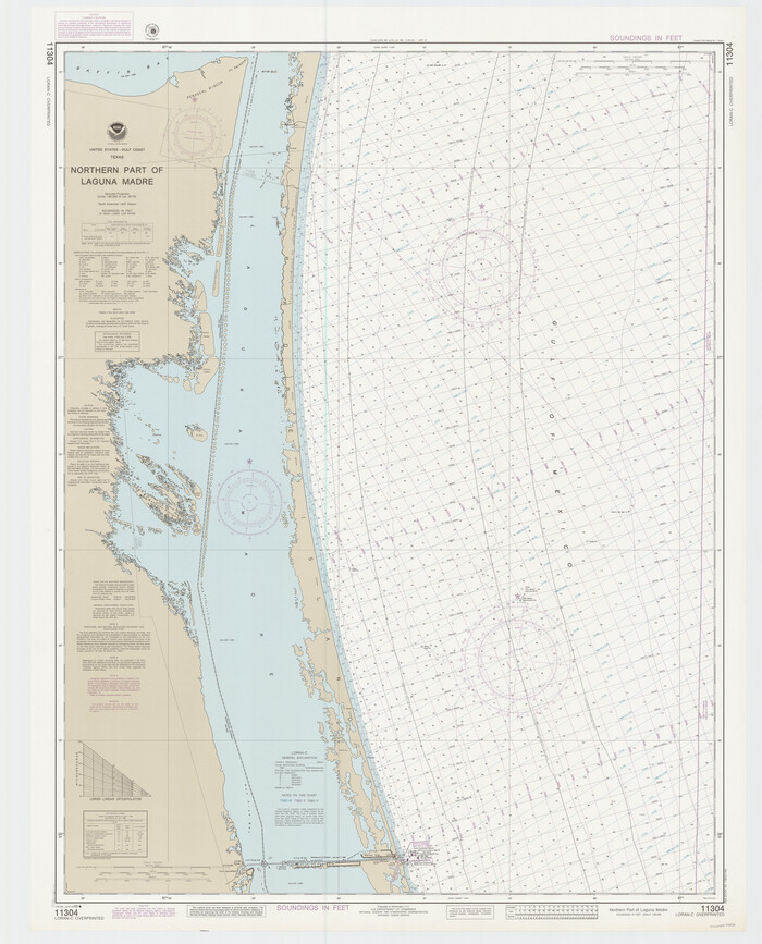
Northern Part of Laguna Madre
Print $20.00
- Digital $50.00
Northern Part of Laguna Madre
1988
Size 45.1 x 36.4 inches
Map/Doc 73531
Henderson County

Print $40.00
- Digital $50.00
Henderson County
1922
Size 39.3 x 49.1 inches
Map/Doc 4683
Marshall Ford Dam right of way survey, General Ownership Map

Print $40.00
- Digital $50.00
Marshall Ford Dam right of way survey, General Ownership Map
1942
Size 36.6 x 55.9 inches
Map/Doc 60402

Current Miscellaneous File 39

Print $20.00
- Digital $50.00
Current Miscellaneous File 39
Size 11.2 x 8.8 inches
Map/Doc 73962
Hall County Rolled Sketch 7

Print $20.00
- Digital $50.00
Hall County Rolled Sketch 7
Size 9.2 x 26.4 inches
Map/Doc 6051
Maps of Gulf Intracoastal Waterway, Texas - Sabine River to the Rio Grande and connecting waterways including ship channels

Print $20.00
- Digital $50.00
Maps of Gulf Intracoastal Waterway, Texas - Sabine River to the Rio Grande and connecting waterways including ship channels
1966
Size 14.5 x 22.4 inches
Map/Doc 61929
Borden County Working Sketch 13

Print $20.00
- Digital $50.00
Borden County Working Sketch 13
1958
Size 24.1 x 35.6 inches
Map/Doc 67473
Flight Mission No. DAH-17M, Frame 61, Orange County

Print $20.00
- Digital $50.00
Flight Mission No. DAH-17M, Frame 61, Orange County
1953
Size 18.6 x 22.5 inches
Map/Doc 86895
[Sketch for Mineral Application 15559 - Hutchinson County, Canadian River]
![65680, [Sketch for Mineral Application 15559 - Hutchinson County, Canadian River], General Map Collection](https://historictexasmaps.com/wmedia_w700/maps/65680-1.tif.jpg)
Print $20.00
- Digital $50.00
[Sketch for Mineral Application 15559 - Hutchinson County, Canadian River]
1926
Size 12.0 x 13.2 inches
Map/Doc 65680
Jefferson County Aerial Photograph Index Sheet 2

Print $20.00
- Digital $50.00
Jefferson County Aerial Photograph Index Sheet 2
1953
Size 23.4 x 17.0 inches
Map/Doc 83708
Sutton County Sketch File 14

Print $20.00
- Digital $50.00
Sutton County Sketch File 14
1924
Size 17.8 x 20.0 inches
Map/Doc 12380
You may also like
Duval County Boundary File 3i

Print $4.00
- Digital $50.00
Duval County Boundary File 3i
Size 8.3 x 10.3 inches
Map/Doc 52751
Flight Mission No. DAG-21K, Frame 117, Matagorda County

Print $20.00
- Digital $50.00
Flight Mission No. DAG-21K, Frame 117, Matagorda County
1952
Size 18.5 x 22.4 inches
Map/Doc 86440
Willacy County

Print $20.00
- Digital $50.00
Willacy County
1921
Size 23.5 x 31.0 inches
Map/Doc 77459
Map of Hill County

Print $20.00
- Digital $50.00
Map of Hill County
1884
Size 47.2 x 36.8 inches
Map/Doc 16851
Mills County Working Sketch 15

Print $20.00
- Digital $50.00
Mills County Working Sketch 15
1951
Size 38.4 x 41.6 inches
Map/Doc 71045
Terry County Sketch File 9

Print $4.00
- Digital $50.00
Terry County Sketch File 9
1917
Size 14.4 x 8.8 inches
Map/Doc 38032
[Map of the Stockdale-Cuero Extension G.H. & S.A. Ry.]
![64096, [Map of the Stockdale-Cuero Extension G.H. & S.A. Ry.], General Map Collection](https://historictexasmaps.com/wmedia_w700/maps/64096.tif.jpg)
Print $40.00
- Digital $50.00
[Map of the Stockdale-Cuero Extension G.H. & S.A. Ry.]
1905
Size 19.4 x 118.2 inches
Map/Doc 64096
Maverick County Sketch File 17

Print $20.00
- Digital $50.00
Maverick County Sketch File 17
Size 15.4 x 18.2 inches
Map/Doc 12052
Upton County Sketch File 14CF

Print $8.00
- Digital $50.00
Upton County Sketch File 14CF
1926
Size 11.3 x 8.8 inches
Map/Doc 38860
Williamson County Sketch File 7

Print $4.00
- Digital $50.00
Williamson County Sketch File 7
1847
Size 12.7 x 7.7 inches
Map/Doc 40316
America sive novvs orbis respectv evropaeorvm inferior globi terrestris pars 1596

Print $20.00
- Digital $50.00
America sive novvs orbis respectv evropaeorvm inferior globi terrestris pars 1596
1596
Size 14.7 x 18.1 inches
Map/Doc 93809
