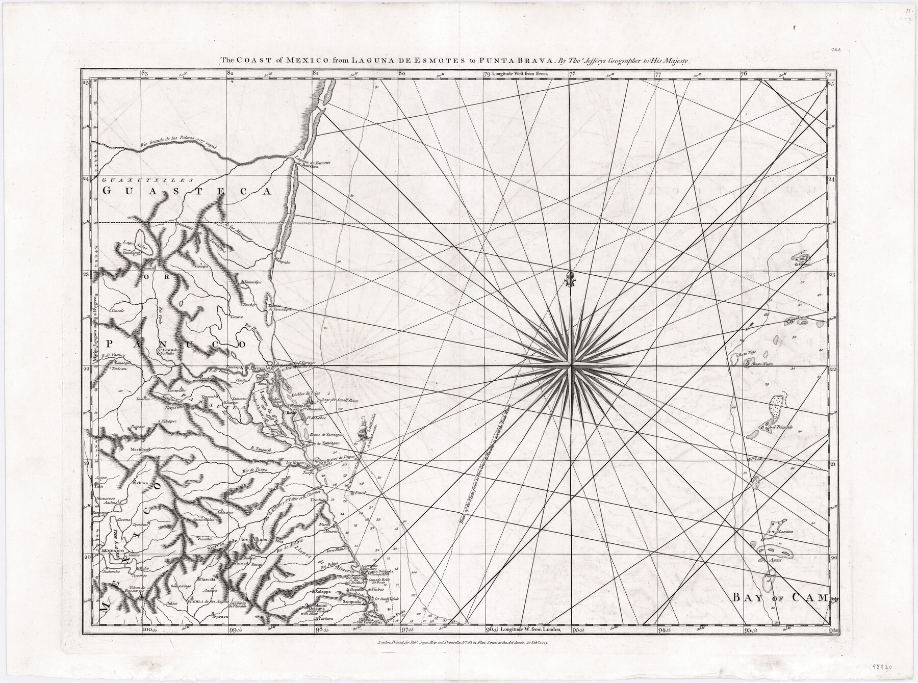
The Coast of Mexico from Laguna de Esmotes to Punta Brava
-
Map/Doc
95920
-
Collection
General Map Collection
-
Object Dates
2/20/1775 (Creation Date)
-
People and Organizations
Thomas Jefferys (Cartographer)
-
Subjects
Gulf of Mexico Mexico Nautical Charts
-
Height x Width
22.2 x 29.8 inches
56.4 x 75.7 cm
-
Medium
paper, etching/engraving/lithograph
Part of: General Map Collection
Rio Grande Rectification Project, El Paso and Juarez Valley

Print $20.00
- Digital $50.00
Rio Grande Rectification Project, El Paso and Juarez Valley
1935
Size 10.8 x 29.6 inches
Map/Doc 60872
Flight Mission No. BRA-8M, Frame 26, Jefferson County

Print $20.00
- Digital $50.00
Flight Mission No. BRA-8M, Frame 26, Jefferson County
1953
Size 18.6 x 22.3 inches
Map/Doc 85581
[Old Surveys, Robertson Colony in Milam County]
![78268, [Old Surveys, Robertson Colony in Milam County], General Map Collection](https://historictexasmaps.com/wmedia_w700/maps/78268.tif.jpg)
Print $20.00
- Digital $50.00
[Old Surveys, Robertson Colony in Milam County]
Size 12.2 x 15.6 inches
Map/Doc 78268
Palo Pinto County Rolled Sketch 10

Print $20.00
- Digital $50.00
Palo Pinto County Rolled Sketch 10
1954
Size 35.4 x 34.1 inches
Map/Doc 9676
Flight Mission No. DQN-2K, Frame 21, Calhoun County

Print $20.00
- Digital $50.00
Flight Mission No. DQN-2K, Frame 21, Calhoun County
1953
Size 18.8 x 22.3 inches
Map/Doc 84228
Hale County Working Sketch 4

Print $20.00
- Digital $50.00
Hale County Working Sketch 4
1979
Size 22.7 x 18.7 inches
Map/Doc 63324
Childress County Sketch File 18

Print $8.00
- Digital $50.00
Childress County Sketch File 18
1909
Size 14.3 x 9.0 inches
Map/Doc 18290
Freestone County Working Sketch 23

Print $20.00
- Digital $50.00
Freestone County Working Sketch 23
1982
Size 20.1 x 17.0 inches
Map/Doc 69265
Val Verde County Working Sketch 28

Print $20.00
- Digital $50.00
Val Verde County Working Sketch 28
1937
Size 45.9 x 38.6 inches
Map/Doc 72163
Map of north end of Brazos Island

Print $20.00
- Digital $50.00
Map of north end of Brazos Island
1845
Size 24.3 x 18.3 inches
Map/Doc 72918
New Map of the State of Texas Compiled from J. De Cordova's large Map

Print $20.00
- Digital $50.00
New Map of the State of Texas Compiled from J. De Cordova's large Map
1856
Size 17.5 x 27.0 inches
Map/Doc 76172
Ochiltree County Sketch File A

Print $22.00
- Digital $50.00
Ochiltree County Sketch File A
1888
Size 8.7 x 5.7 inches
Map/Doc 33167
You may also like
[Sketch for Mineral Application 26543 - Sabine River, D. H. Sanford]
![65677, [Sketch for Mineral Application 26543 - Sabine River, D. H. Sanford], General Map Collection](https://historictexasmaps.com/wmedia_w700/maps/65677.tif.jpg)
Print $40.00
- Digital $50.00
[Sketch for Mineral Application 26543 - Sabine River, D. H. Sanford]
1931
Size 30.8 x 71.9 inches
Map/Doc 65677
[Part of Map Showing Terry & Lynn County Line Highlighting Parts of Blocks D8, E, 9]
![92264, [Part of Map Showing Terry & Lynn County Line Highlighting Parts of Blocks D8, E, 9], Twichell Survey Records](https://historictexasmaps.com/wmedia_w700/maps/92264-1.tif.jpg)
Print $20.00
- Digital $50.00
[Part of Map Showing Terry & Lynn County Line Highlighting Parts of Blocks D8, E, 9]
Size 18.2 x 10.9 inches
Map/Doc 92264
Nueces County Rolled Sketch M-9

Print $20.00
- Digital $50.00
Nueces County Rolled Sketch M-9
1913
Size 37.6 x 38.3 inches
Map/Doc 9588
Austin County Working Sketch 4

Print $20.00
- Digital $50.00
Austin County Working Sketch 4
1959
Size 29.8 x 34.8 inches
Map/Doc 67245
Kimble County Sketch File B

Print $22.00
- Digital $50.00
Kimble County Sketch File B
Size 14.3 x 12.7 inches
Map/Doc 28963
Flight Mission No. DAG-21K, Frame 128, Matagorda County

Print $20.00
- Digital $50.00
Flight Mission No. DAG-21K, Frame 128, Matagorda County
1952
Size 18.4 x 22.3 inches
Map/Doc 86454
Val Verde County Working Sketch 14

Print $20.00
- Digital $50.00
Val Verde County Working Sketch 14
1926
Size 17.2 x 18.9 inches
Map/Doc 72149
Map of Location and Right of Way from El Paso, Tex. To New Mexico Line, Rio Grande & El Paso R.R.

Print $20.00
- Digital $50.00
Map of Location and Right of Way from El Paso, Tex. To New Mexico Line, Rio Grande & El Paso R.R.
Size 14.0 x 20.9 inches
Map/Doc 64085
Irion County Sketch File 12

Print $40.00
- Digital $50.00
Irion County Sketch File 12
1939
Size 15.3 x 12.4 inches
Map/Doc 27482
Montgomery County Working Sketch 30

Print $20.00
- Digital $50.00
Montgomery County Working Sketch 30
1946
Size 30.7 x 34.8 inches
Map/Doc 71137
Midland County Working Sketch 25

Print $40.00
- Digital $50.00
Midland County Working Sketch 25
1957
Size 58.3 x 49.1 inches
Map/Doc 71006
Ellis County Working Sketch 2

Print $20.00
- Digital $50.00
Ellis County Working Sketch 2
1947
Size 27.0 x 25.6 inches
Map/Doc 69018