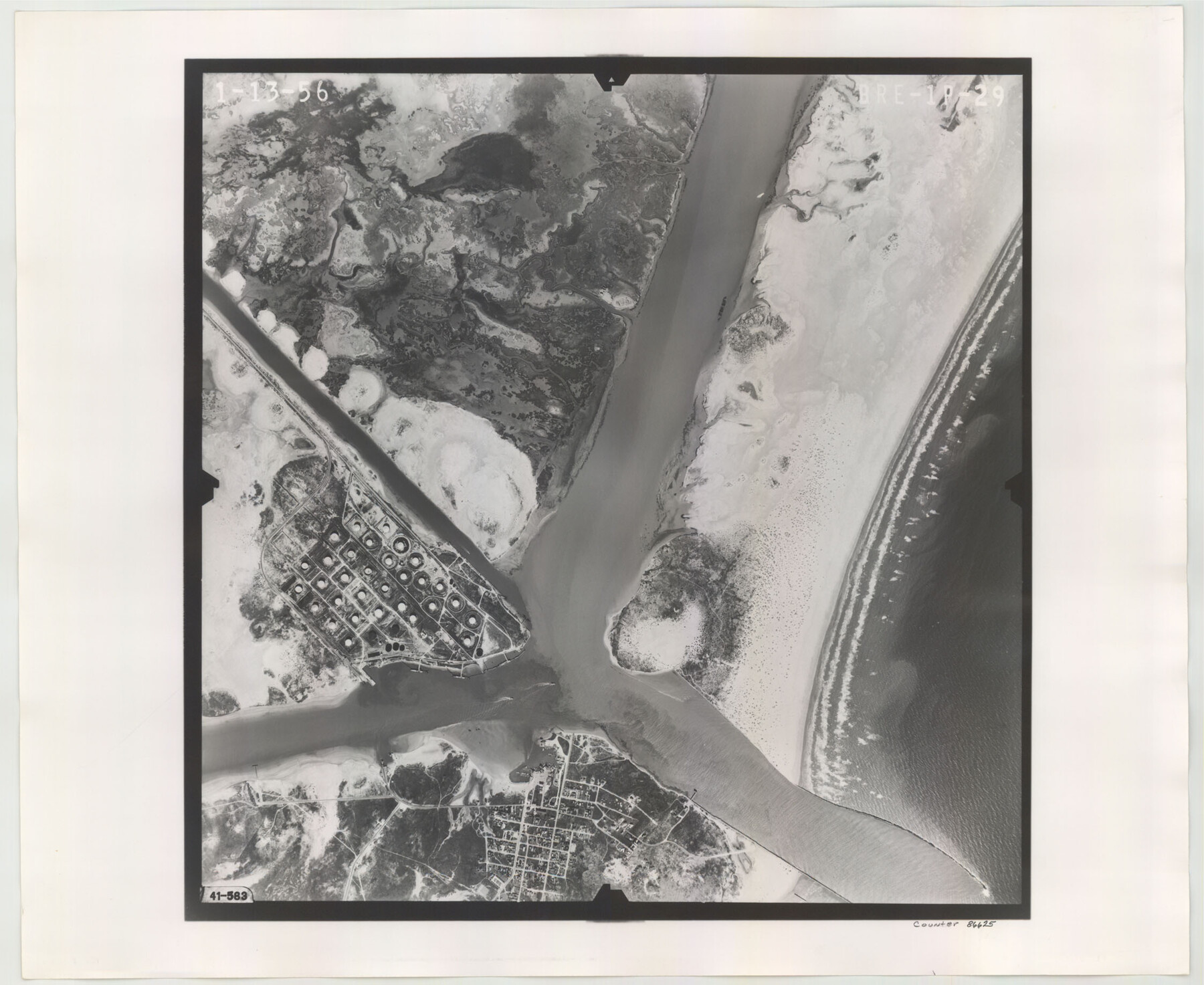
Flight Mission No. BRE-1P, Frame 29, Nueces County
BRE-1P-29
-
Map/Doc
86625
-
Collection
General Map Collection
-
Object Dates
1956/1/13 (Creation Date)
-
People and Organizations
U. S. Department of Agriculture (Publisher)
-
Counties
Nueces
-
Subjects
Aerial Photograph
-
Height x Width
18.4 x 22.5 inches
46.7 x 57.2 cm
-
Comments
Flown by V. L. Beavers and Associates of San Antonio, Texas.
Part of: General Map Collection
Newton County Sketch File 7

Print $4.00
- Digital $50.00
Newton County Sketch File 7
1872
Size 6.1 x 8.3 inches
Map/Doc 32374

Wichita County Sketch File 21

Print $4.00
- Digital $50.00
Wichita County Sketch File 21
Size 11.5 x 8.8 inches
Map/Doc 40102
Harris County Working Sketch 15

Print $20.00
- Digital $50.00
Harris County Working Sketch 15
1916
Size 29.3 x 41.2 inches
Map/Doc 65907

Reagan County Working Sketch 18

Print $20.00
- Digital $50.00
Reagan County Working Sketch 18
1954
Size 23.6 x 42.9 inches
Map/Doc 71860
Terry County Sketch File 8

Print $20.00
- Digital $50.00
Terry County Sketch File 8
1932
Size 23.2 x 42.5 inches
Map/Doc 10393
Mason County Boundary File 5a

Print $40.00
- Digital $50.00
Mason County Boundary File 5a
Size 18.0 x 32.6 inches
Map/Doc 56872
Packery Channel

Print $20.00
- Digital $50.00
Packery Channel
1975
Size 27.8 x 30.9 inches
Map/Doc 2994
Val Verde County Working Sketch 97

Print $20.00
- Digital $50.00
Val Verde County Working Sketch 97
1980
Size 41.7 x 47.6 inches
Map/Doc 72232
Wise County Working Sketch 14

Print $20.00
- Digital $50.00
Wise County Working Sketch 14
1977
Size 19.0 x 18.0 inches
Map/Doc 72628
Jeff Davis County Rolled Sketch 21

Print $20.00
- Digital $50.00
Jeff Davis County Rolled Sketch 21
1946
Size 46.5 x 38.7 inches
Map/Doc 9267
You may also like
Ile de la Réunion, Colonie Française (Océan indien)

Print $20.00
- Digital $50.00
Ile de la Réunion, Colonie Française (Océan indien)
Size 14.5 x 20.5 inches
Map/Doc 94451
Motley County Sketch File 2-D

Print $40.00
- Digital $50.00
Motley County Sketch File 2-D
1903
Size 16.3 x 24.7 inches
Map/Doc 42134
[Surveys East of river copied from U.S. map of Township No. 6 South, Range No. 9 West of the Indian Meridian, Oklahoma]
![75185, [Surveys East of river copied from U.S. map of Township No. 6 South, Range No. 9 West of the Indian Meridian, Oklahoma], General Map Collection](https://historictexasmaps.com/wmedia_w700/maps/75185.tif.jpg)
Print $2.00
- Digital $50.00
[Surveys East of river copied from U.S. map of Township No. 6 South, Range No. 9 West of the Indian Meridian, Oklahoma]
Size 13.3 x 9.0 inches
Map/Doc 75185
San Saba County

Print $40.00
- Digital $50.00
San Saba County
1918
Size 49.0 x 43.0 inches
Map/Doc 63023

Montgomery County Working Sketch 75

Print $40.00
- Digital $50.00
Montgomery County Working Sketch 75
1986
Size 30.9 x 82.8 inches
Map/Doc 71182
Culberson County Working Sketch 58

Print $20.00
- Digital $50.00
Culberson County Working Sketch 58
1974
Size 45.2 x 35.1 inches
Map/Doc 68512
Map of Falls County

Print $20.00
- Digital $50.00
Map of Falls County
1855
Size 21.4 x 23.9 inches
Map/Doc 3532
Potter County Working Sketch 6

Print $20.00
- Digital $50.00
Potter County Working Sketch 6
1959
Size 23.3 x 27.0 inches
Map/Doc 71666
The Republic County of Sabine. Boundaries Defined, December14, 1837

Print $20.00
The Republic County of Sabine. Boundaries Defined, December14, 1837
2020
Size 17.6 x 21.7 inches
Map/Doc 96269
Upton County Rolled Sketch 37

Print $20.00
- Digital $50.00
Upton County Rolled Sketch 37
Size 41.8 x 39.6 inches
Map/Doc 10053
Nueces County Rolled Sketch 80

Print $58.00
Nueces County Rolled Sketch 80
1982
Size 24.2 x 36.7 inches
Map/Doc 6952