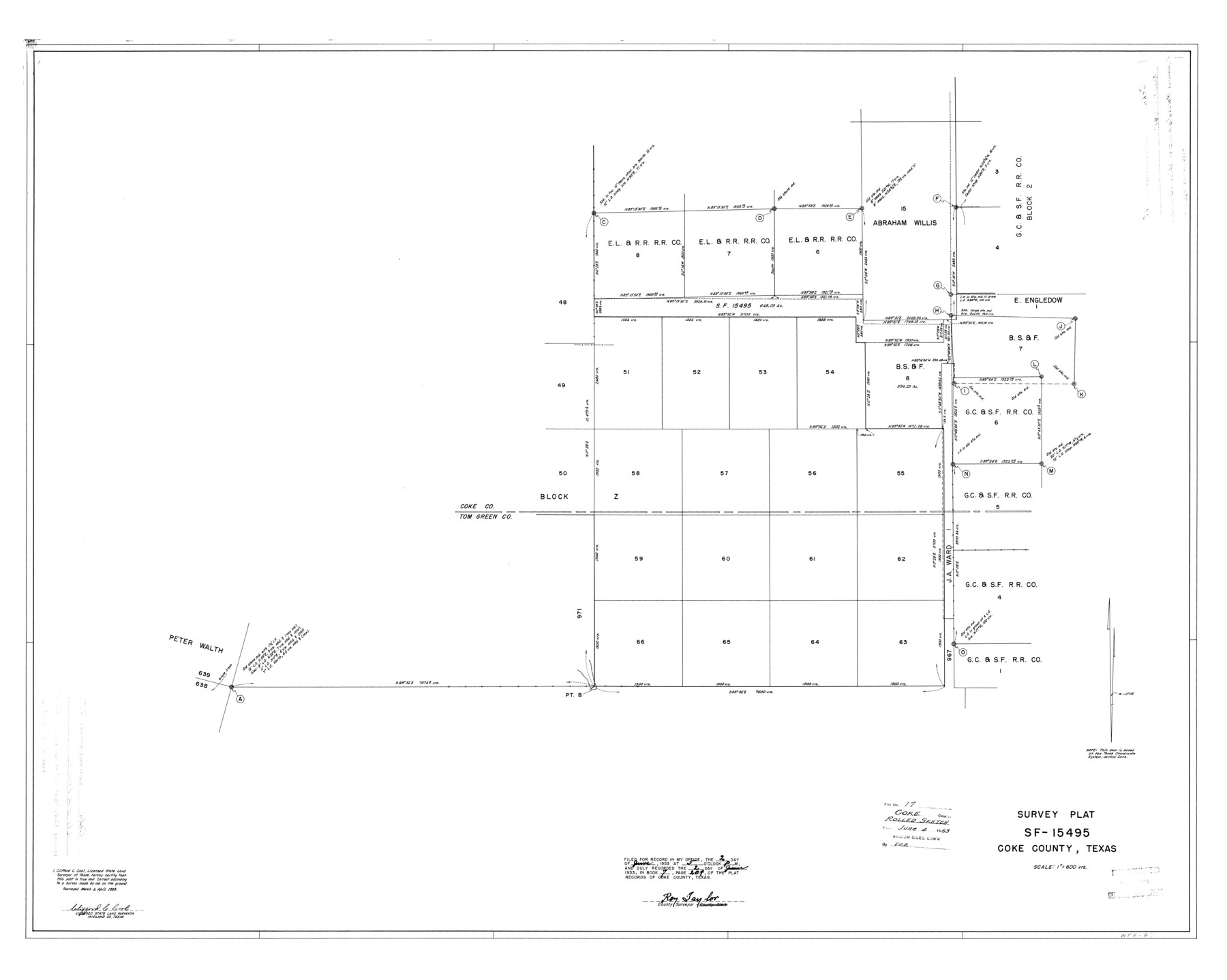
Coke County Rolled Sketch 17
Survey plat, SF-15495 Coke County, Texas
-
Map/Doc
8631
-
Collection
General Map Collection
-
Object Dates
4/1953 (Creation Date)
6/4/1953 (File Date)
-
People and Organizations
Clifford C. Cool (Surveyor/Engineer)
-
Counties
Coke Tom Green
-
Subjects
Surveying Rolled Sketch
-
Height x Width
36.1 x 45.2 inches
91.7 x 114.8 cm
-
Scale
1" = 600 varas
Part of: General Map Collection
[Jack District]
![1993, [Jack District], General Map Collection](https://historictexasmaps.com/wmedia_w700/maps/1993-1.tif.jpg)
Print $40.00
- Digital $50.00
[Jack District]
1878
Size 42.1 x 64.5 inches
Map/Doc 1993
Flight Mission No. BRA-9M, Frame 74, Jefferson County

Print $20.00
- Digital $50.00
Flight Mission No. BRA-9M, Frame 74, Jefferson County
1953
Size 18.6 x 22.4 inches
Map/Doc 85657
Map of the Western Part of Bexar District

Print $40.00
- Digital $50.00
Map of the Western Part of Bexar District
1849
Size 63.7 x 36.2 inches
Map/Doc 87376
Hudspeth County Rolled Sketch 49

Print $40.00
- Digital $50.00
Hudspeth County Rolled Sketch 49
Size 42.8 x 53.8 inches
Map/Doc 9219
Roberts County Working Sketch 4

Print $20.00
- Digital $50.00
Roberts County Working Sketch 4
1945
Size 37.1 x 32.8 inches
Map/Doc 63530
Val Verde County Rolled Sketch 66

Print $40.00
- Digital $50.00
Val Verde County Rolled Sketch 66
1957
Size 30.7 x 55.0 inches
Map/Doc 10084
Map Showing Location and Right of Way of Proposed Groins - to be built by U.S. Government Along Seawall at Galveston, Texas

Print $20.00
- Digital $50.00
Map Showing Location and Right of Way of Proposed Groins - to be built by U.S. Government Along Seawall at Galveston, Texas
1935
Size 20.8 x 36.3 inches
Map/Doc 73622
Kinney County Working Sketch 44

Print $20.00
- Digital $50.00
Kinney County Working Sketch 44
1978
Size 36.7 x 25.8 inches
Map/Doc 70226

Wichita County Working Sketch 24

Print $20.00
- Digital $50.00
Wichita County Working Sketch 24
1971
Size 21.2 x 16.2 inches
Map/Doc 72534
Lubbock County Working Sketch 9

Print $40.00
- Digital $50.00
Lubbock County Working Sketch 9
1990
Size 28.5 x 57.3 inches
Map/Doc 70669
Limestone County Working Sketch 21

Print $20.00
- Digital $50.00
Limestone County Working Sketch 21
1979
Size 29.4 x 38.7 inches
Map/Doc 70571
You may also like
Haskell County Sketch File 11

Print $6.00
- Digital $50.00
Haskell County Sketch File 11
1886
Size 16.0 x 10.7 inches
Map/Doc 26140
Map of part of Waller County

Print $20.00
- Digital $50.00
Map of part of Waller County
Size 16.3 x 13.5 inches
Map/Doc 685
Drainage Basins of Texas Streams

Print $20.00
- Digital $50.00
Drainage Basins of Texas Streams
Size 17.0 x 19.3 inches
Map/Doc 65269
Tarrant County Sketch File 36

Print $56.00
- Digital $50.00
Tarrant County Sketch File 36
2018
Size 11.0 x 8.5 inches
Map/Doc 95395
Cass County Rolled Sketch OPD

Print $20.00
- Digital $50.00
Cass County Rolled Sketch OPD
1936
Size 29.6 x 24.9 inches
Map/Doc 5415
Presidio County Working Sketch 148

Print $20.00
- Digital $50.00
Presidio County Working Sketch 148
1991
Size 31.7 x 42.7 inches
Map/Doc 71826

Brazos River, Brazos River Sheet 2

Print $20.00
- Digital $50.00
Brazos River, Brazos River Sheet 2
1926
Size 25.2 x 31.0 inches
Map/Doc 78265
1988 Land Use - El Paso, Ciudad Juarez and Vicinity

Print $20.00
- Digital $50.00
1988 Land Use - El Paso, Ciudad Juarez and Vicinity
1988
Size 34.1 x 25.0 inches
Map/Doc 87370
Adrian Heights Adition (sic) to Adrian Located in Section 16, Block K11

Print $2.00
- Digital $50.00
Adrian Heights Adition (sic) to Adrian Located in Section 16, Block K11
Size 15.6 x 7.7 inches
Map/Doc 92096
Fannin County Sketch File 10

Print $20.00
- Digital $50.00
Fannin County Sketch File 10
Size 21.0 x 16.0 inches
Map/Doc 11471
[Surveys in the Travis District along the Colorado River]
![118, [Surveys in the Travis District along the Colorado River], General Map Collection](https://historictexasmaps.com/wmedia_w700/maps/118.tif.jpg)
Print $2.00
- Digital $50.00
[Surveys in the Travis District along the Colorado River]
1841
Size 8.6 x 15.3 inches
Map/Doc 118