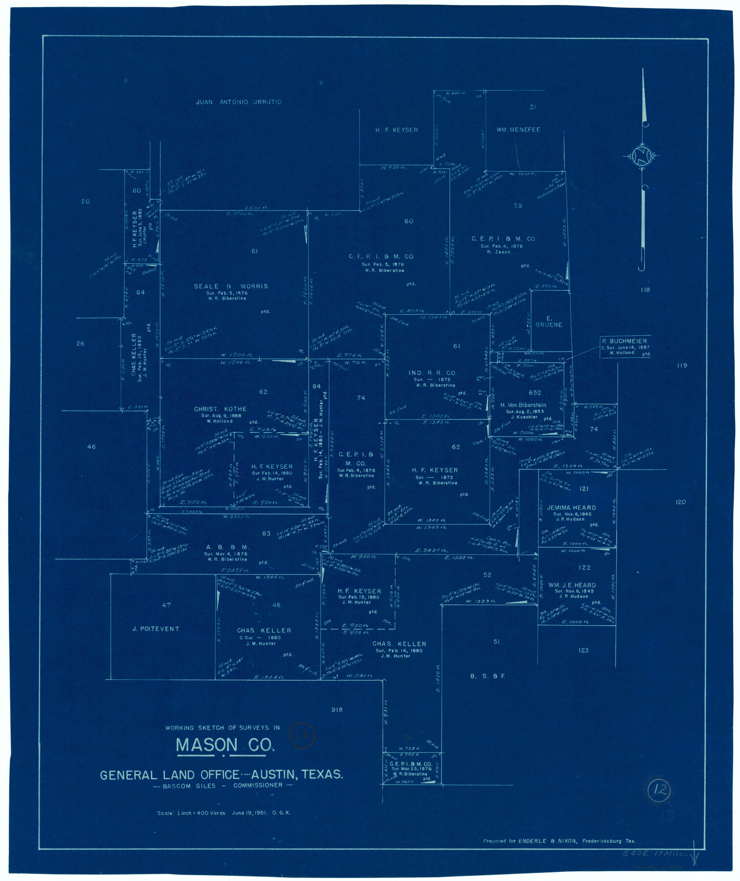
Mason County Working Sketch 12
-
Map/Doc
70848
-
Collection
General Map Collection
-
Object Dates
6/19/1951 (Creation Date)
-
People and Organizations
Otto G. Kurio (Draftsman)
-
Counties
Mason
-
Subjects
Surveying Working Sketch
-
Height x Width
28.1 x 23.6 inches
71.4 x 59.9 cm
-
Scale
1" = 400 varas
Part of: General Map Collection
Flight Mission No. CLL-3N, Frame 3, Willacy County

Print $20.00
- Digital $50.00
Flight Mission No. CLL-3N, Frame 3, Willacy County
1954
Size 18.6 x 22.3 inches
Map/Doc 87069
Jim Wells Co.

Print $20.00
- Digital $50.00
Jim Wells Co.
1913
Size 43.1 x 21.4 inches
Map/Doc 66886
Stephens County Working Sketch 37

Print $40.00
- Digital $50.00
Stephens County Working Sketch 37
1983
Size 42.9 x 67.7 inches
Map/Doc 63980
Bandera County Boundary File 5

Print $44.00
- Digital $50.00
Bandera County Boundary File 5
Size 14.2 x 8.7 inches
Map/Doc 50299
Hardin County Sketch File 30a

Print $4.00
- Digital $50.00
Hardin County Sketch File 30a
Size 12.1 x 7.7 inches
Map/Doc 25160
Aransas County NRC Article 33.136 Sketch 6

Print $23.00
- Digital $50.00
Aransas County NRC Article 33.136 Sketch 6
2005
Size 25.1 x 36.4 inches
Map/Doc 83522

Sabine County Sketch File 11

Print $4.00
Sabine County Sketch File 11
Size 6.2 x 8.3 inches
Map/Doc 35629
Topographical Map of the Rio Grande, Sheet No. 7

Print $20.00
- Digital $50.00
Topographical Map of the Rio Grande, Sheet No. 7
1912
Map/Doc 89531

Flight Mission No. CRC-2R, Frame 2, Chambers County

Print $20.00
- Digital $50.00
Flight Mission No. CRC-2R, Frame 2, Chambers County
1956
Size 18.6 x 22.4 inches
Map/Doc 84721
Van Zandt County Sketch File 5

Print $22.00
- Digital $50.00
Van Zandt County Sketch File 5
Size 20.5 x 6.3 inches
Map/Doc 39371
You may also like
Flight Mission No. CLL-4N, Frame 35, Willacy County

Print $20.00
- Digital $50.00
Flight Mission No. CLL-4N, Frame 35, Willacy County
1954
Size 18.3 x 22.0 inches
Map/Doc 87108

Fisher County Rolled Sketch 5

Print $20.00
- Digital $50.00
Fisher County Rolled Sketch 5
1961
Size 40.3 x 32.5 inches
Map/Doc 10659
Brazoria County Sketch File 10

Print $40.00
- Digital $50.00
Brazoria County Sketch File 10
Size 16.4 x 12.7 inches
Map/Doc 14938
Sherman County, Texas

Print $20.00
- Digital $50.00
Sherman County, Texas
1888
Size 23.1 x 18.5 inches
Map/Doc 754

Bandera County Sketch File 20

Print $40.00
- Digital $50.00
Bandera County Sketch File 20
Size 18.7 x 13.6 inches
Map/Doc 10894
Harris County Rolled Sketch 86

Print $20.00
- Digital $50.00
Harris County Rolled Sketch 86
Size 20.7 x 42.9 inches
Map/Doc 73578
Brazoria County NRC Article 33.136 Sketch 27

Print $24.00
Brazoria County NRC Article 33.136 Sketch 27
2025
Map/Doc 97472
Fort Bend County Boundary File 2a

Print $42.00
- Digital $50.00
Fort Bend County Boundary File 2a
Size 23.7 x 34.3 inches
Map/Doc 53563
El Paso County Working Sketch 58

Print $20.00
- Digital $50.00
El Paso County Working Sketch 58
Size 25.8 x 30.6 inches
Map/Doc 69080
[Sketch of Sullivan Property]
![75775, [Sketch of Sullivan Property], Maddox Collection](https://historictexasmaps.com/wmedia_w700/maps/75775.tif.jpg)
Print $20.00
- Digital $50.00
[Sketch of Sullivan Property]
Size 14.3 x 22.7 inches
Map/Doc 75775