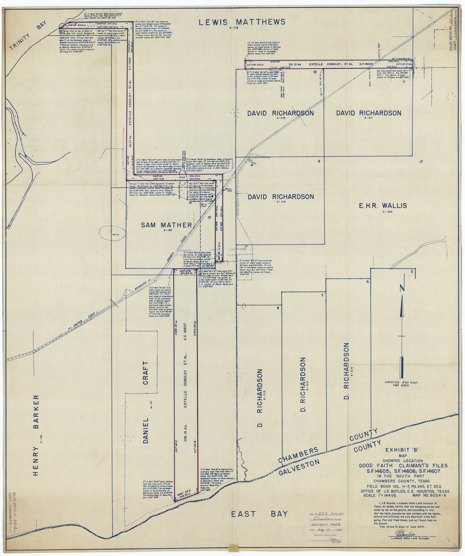
Chambers County Rolled Sketch 25A
Exhibit 'B' - Map showing location Good Faith Claimant's files SF-14605, SF-14606, SF-14607 in the south part Chambers County, Texas
-
Map/Doc
8617
-
Collection
General Map Collection
-
Object Dates
1944/6/16 (Creation Date)
1944/8/11 (File Date)
-
People and Organizations
J.S. Boyles (Surveyor/Engineer)
-
Counties
Chambers
-
Subjects
Surveying Rolled Sketch
-
Height x Width
41.2 x 34.5 inches
104.6 x 87.6 cm
-
Medium
blueprint/diazo
-
Scale
1" = 144 varas
-
Comments
See Chambers County Rolled Sketch 25 (8618) for Exhibit 'A'.
Related maps
Chambers County Rolled Sketch 25

Print $20.00
- Digital $50.00
Chambers County Rolled Sketch 25
1944
Size 33.9 x 31.5 inches
Map/Doc 8618
Part of: General Map Collection
Hale County Boundary File 4a

Print $60.00
- Digital $50.00
Hale County Boundary File 4a
Size 31.2 x 41.9 inches
Map/Doc 54068
Shackelford County Rolled Sketch 7

Print $20.00
- Digital $50.00
Shackelford County Rolled Sketch 7
2009
Size 36.9 x 24.8 inches
Map/Doc 89229
Galveston County Rolled Sketch 11

Print $40.00
- Digital $50.00
Galveston County Rolled Sketch 11
1928
Size 29.7 x 169.5 inches
Map/Doc 9089
Starr County Sketch File 37

Print $10.00
- Digital $50.00
Starr County Sketch File 37
1940
Size 2.7 x 8.8 inches
Map/Doc 36980
Marion County Rolled Sketch F

Print $40.00
- Digital $50.00
Marion County Rolled Sketch F
1937
Size 43.5 x 67.1 inches
Map/Doc 9487
Milam County Boundary File 1

Print $8.00
- Digital $50.00
Milam County Boundary File 1
Size 12.7 x 8.2 inches
Map/Doc 57198
Haskell County Working Sketch 1

Print $40.00
- Digital $50.00
Haskell County Working Sketch 1
Size 31.0 x 74.5 inches
Map/Doc 66059
McMullen County Sketch File 20

Print $4.00
- Digital $50.00
McMullen County Sketch File 20
Size 8.1 x 10.0 inches
Map/Doc 31373
Fayette County Sketch File 6

Print $114.00
- Digital $50.00
Fayette County Sketch File 6
1981
Size 14.9 x 9.5 inches
Map/Doc 22508
Shackelford County

Print $20.00
- Digital $50.00
Shackelford County
1972
Size 43.9 x 37.3 inches
Map/Doc 95638
Webb County Sketch File 62

Print $6.00
- Digital $50.00
Webb County Sketch File 62
1946
Size 11.5 x 9.0 inches
Map/Doc 39862
Donley County Sketch File 10

Print $8.00
- Digital $50.00
Donley County Sketch File 10
1889
Size 9.6 x 6.1 inches
Map/Doc 21240
You may also like
Brewster County Rolled Sketch 114

Print $20.00
- Digital $50.00
Brewster County Rolled Sketch 114
1964
Size 11.8 x 18.5 inches
Map/Doc 5264
Tom Green County Sketch File 80

Print $20.00
- Digital $50.00
Tom Green County Sketch File 80
1962
Size 20.6 x 35.6 inches
Map/Doc 12452
The Peters Colony. August 30, 1841

Print $20.00
The Peters Colony. August 30, 1841
2020
Size 21.7 x 21.7 inches
Map/Doc 96362
Hood County Working Sketch 2

Print $20.00
- Digital $50.00
Hood County Working Sketch 2
1956
Size 20.5 x 25.5 inches
Map/Doc 66196
Williamson County Working Sketch 17

Print $20.00
- Digital $50.00
Williamson County Working Sketch 17
1984
Size 32.7 x 24.0 inches
Map/Doc 72577
University Lands, Blocks 1-13 & Block 58, Crockett, Reagan & Upton Counties

Print $20.00
- Digital $50.00
University Lands, Blocks 1-13 & Block 58, Crockett, Reagan & Upton Counties
1936
Size 36.9 x 42.0 inches
Map/Doc 2409

Martin County Rolled Sketch 2

Print $20.00
- Digital $50.00
Martin County Rolled Sketch 2
1906
Size 36.5 x 31.3 inches
Map/Doc 9492
Live Oak County Rolled Sketch 8

Print $20.00
- Digital $50.00
Live Oak County Rolled Sketch 8
1969
Size 43.5 x 32.8 inches
Map/Doc 9455
Mills County Sketch File 4a

Print $3.00
- Digital $50.00
Mills County Sketch File 4a
1874
Size 14.5 x 10.1 inches
Map/Doc 31651

Coast Chart No. 210 Aransas Pass and Corpus Christi Bay with the coast to latitude 27° 12' Texas

Print $20.00
- Digital $50.00
Coast Chart No. 210 Aransas Pass and Corpus Christi Bay with the coast to latitude 27° 12' Texas
1913
Size 27.9 x 18.3 inches
Map/Doc 72806