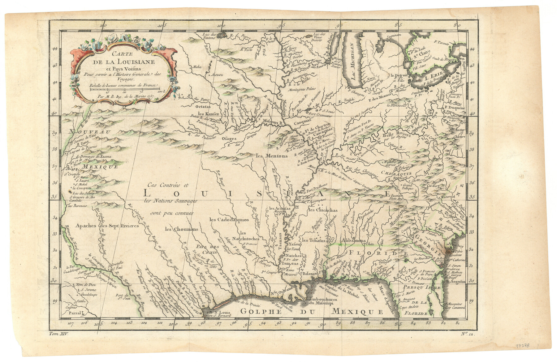
Carte de la Louisiane et Pays Voisins pour servir a l'Histoire Generale des Voyages
-
Map/Doc
97278
-
Collection
General Map Collection
-
Object Dates
1757 (Creation Date)
-
People and Organizations
Chase Untermeyer (Donor)
Jacques Nicolas Bellin (Cartographer)
-
Subjects
North America
-
Height x Width
10.1 x 15.5 inches
25.7 x 39.4 cm
-
Comments
Donated by Ambassador Chase Untermeyer in June 2024.
Relief shown pictorially.
From Jean Françoise de la Harpe's Abrégé de l'histoire générale des voyages. 1780.
In lower left margin: "Tom. XIV"; in lower right margin: "No. 12"
Part of: General Map Collection
Rand McNally Standard Map of Texas

Rand McNally Standard Map of Texas
1930
Size 34.6 x 28.0 inches
Map/Doc 2147

Red River County Working Sketch 7

Print $20.00
- Digital $50.00
Red River County Working Sketch 7
1919
Size 25.0 x 24.1 inches
Map/Doc 71990
Texas Intracoastal Waterway - Laguna Madre - Rincon de San Jose to Chubby Island

Print $20.00
- Digital $50.00
Texas Intracoastal Waterway - Laguna Madre - Rincon de San Jose to Chubby Island
1957
Size 39.2 x 27.1 inches
Map/Doc 73512
Crosby County Sketch File B

Print $20.00
- Digital $50.00
Crosby County Sketch File B
1877
Size 21.9 x 21.0 inches
Map/Doc 11259
Nacogdoches County Boundary File 1

Print $36.00
- Digital $50.00
Nacogdoches County Boundary File 1
Size 6.7 x 4.4 inches
Map/Doc 57562
Texas & Pacific Ry Reserve west of the Pecos River

Print $40.00
- Digital $50.00
Texas & Pacific Ry Reserve west of the Pecos River
1880
Size 43.9 x 90.6 inches
Map/Doc 3047
Reagan County Working Sketch 42

Print $20.00
- Digital $50.00
Reagan County Working Sketch 42
1973
Size 19.9 x 37.0 inches
Map/Doc 71884
Map of Dallas County

Print $20.00
- Digital $50.00
Map of Dallas County
Size 22.2 x 18.5 inches
Map/Doc 3464
Flight Mission No. DAG-21K, Frame 84, Matagorda County

Print $20.00
- Digital $50.00
Flight Mission No. DAG-21K, Frame 84, Matagorda County
1952
Size 18.6 x 22.3 inches
Map/Doc 86413
Carta General de la República Mexicana Formada para el estudio de la configuracion y division interior de su territorio

Print $20.00
- Digital $50.00
Carta General de la República Mexicana Formada para el estudio de la configuracion y division interior de su territorio
Size 23.2 x 29.4 inches
Map/Doc 95823
Pecos County Working Sketch 10

Print $20.00
- Digital $50.00
Pecos County Working Sketch 10
1907
Size 25.9 x 23.9 inches
Map/Doc 71480
You may also like
Colorado County Working Sketch Graphic Index

Print $40.00
- Digital $50.00
Colorado County Working Sketch Graphic Index
1946
Size 52.7 x 42.4 inches
Map/Doc 76500
Mapa de los Estados Unidos Mejicanos arreglado a la distribucion que en diversos decretos ha hecho del territorio el Congreso General Mejicano

Print $20.00
- Digital $50.00
Mapa de los Estados Unidos Mejicanos arreglado a la distribucion que en diversos decretos ha hecho del territorio el Congreso General Mejicano
1851
Size 24.6 x 30.3 inches
Map/Doc 96514
Flight Mission No. BRE-1P, Frame 72, Nueces County

Print $20.00
- Digital $50.00
Flight Mission No. BRE-1P, Frame 72, Nueces County
1956
Size 18.4 x 22.3 inches
Map/Doc 86654
City of Corpus Christi, Texas

Print $20.00
- Digital $50.00
City of Corpus Christi, Texas
1969
Size 22.6 x 51.0 inches
Map/Doc 96520
Flight Mission No. CGI-3N, Frame 73, Cameron County

Print $20.00
- Digital $50.00
Flight Mission No. CGI-3N, Frame 73, Cameron County
1954
Size 18.4 x 22.4 inches
Map/Doc 84567
Oldham County Working Sketch 5

Print $40.00
- Digital $50.00
Oldham County Working Sketch 5
1951
Size 43.0 x 59.3 inches
Map/Doc 71327
Coke County Sketch File AB

Print $12.00
- Digital $50.00
Coke County Sketch File AB
1884
Size 14.1 x 8.7 inches
Map/Doc 18608
Henderson County Working Sketch 22

Print $20.00
- Digital $50.00
Henderson County Working Sketch 22
1951
Size 26.5 x 31.2 inches
Map/Doc 66155
El Paso County

Print $40.00
- Digital $50.00
El Paso County
1881
Size 52.6 x 42.4 inches
Map/Doc 89058
Galveston County Sketch File 49

Print $2.00
- Digital $50.00
Galveston County Sketch File 49
Size 5.5 x 8.6 inches
Map/Doc 23480
Wharton County Sketch File 24

Print $20.00
- Digital $50.00
Wharton County Sketch File 24
1919
Size 19.9 x 25.5 inches
Map/Doc 12668
Sutton County Rolled Sketch F

Print $20.00
- Digital $50.00
Sutton County Rolled Sketch F
Size 12.7 x 38.9 inches
Map/Doc 7903