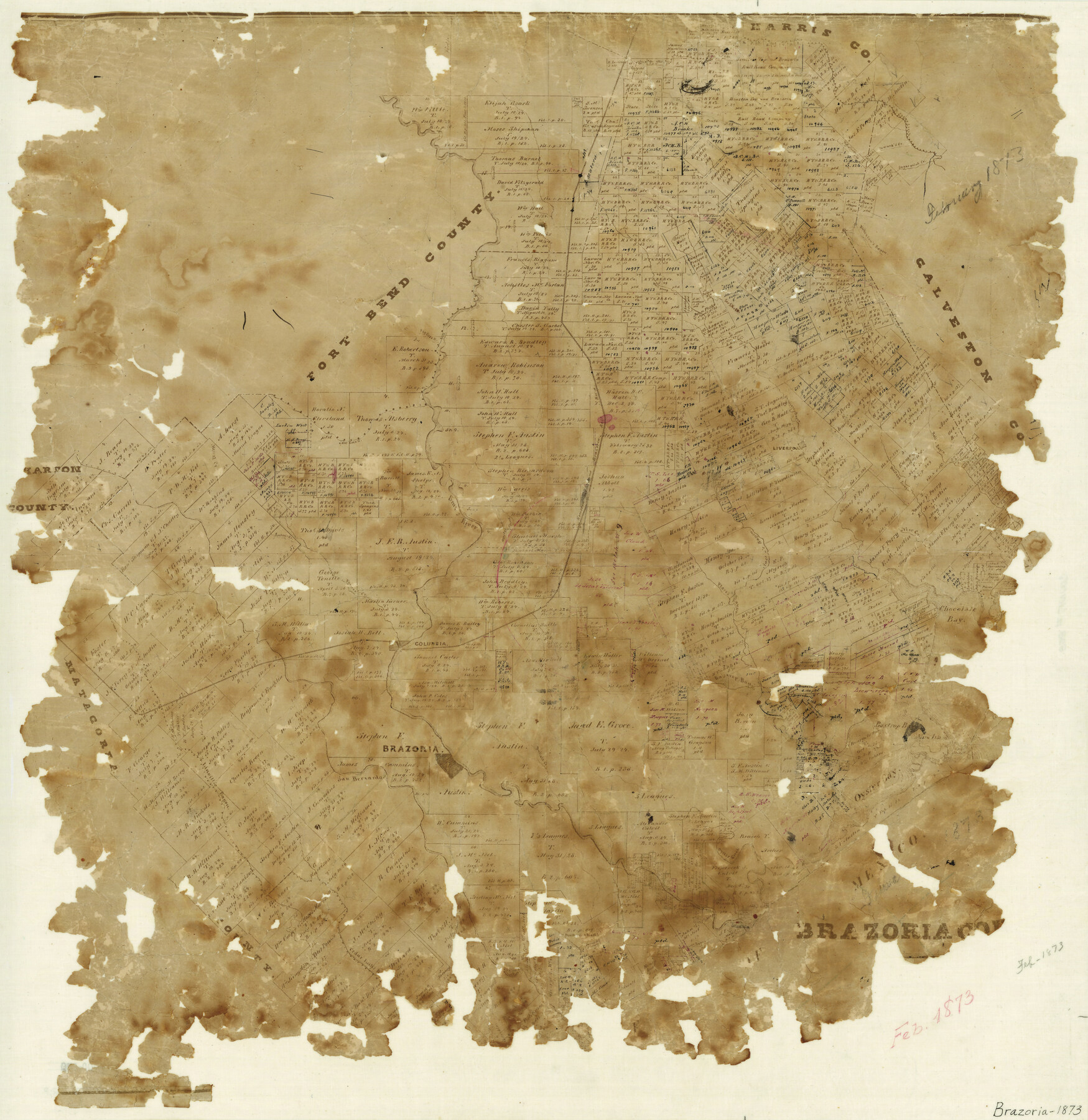
Brazoria County
-
Map/Doc
858
-
Collection
General Map Collection
-
Object Dates
2/1873 (Creation Date)
-
People and Organizations
Texas General Land Office (Publisher)
-
Counties
Brazoria
-
Subjects
County
-
Height x Width
26.7 x 26.1 inches
67.8 x 66.3 cm
-
Features
Brazoria
Chocolate Bay
Flores Bayou
Varner's Creek
Columbia
Bastrop Bay
Bastrop Bayou
Linvill's [sic] Baou
San Bernardo River
New Creek
Buffalo Creek
Oyster Bay
Mud Island
Gulf of Mexico
Onion Bayou
Cedar Lake Bayou
San Luis Island
Chocolate Bayou
Howard's Creek
Sugarpoint Creek
Dickenson's [sic] Bayou
Mustang Slough
West Prong of Chocolate Bayou
Big Creek
Cow Creek
HT&B
Clear Creek
Liverpool
Hall's Bayou
Brazos River
Mount Creek
Bailey's Creek
Oyster Creek
Austin's Bayou
Part of: General Map Collection
A New Map of Texas, Oregon, and California with the regions adjoining compiled from the most recent authorities

Print $20.00
- Digital $50.00
A New Map of Texas, Oregon, and California with the regions adjoining compiled from the most recent authorities
1846
Size 23.0 x 21.2 inches
Map/Doc 95748
Atascosa County Working Sketch 5

Print $3.00
- Digital $50.00
Atascosa County Working Sketch 5
1913
Size 10.9 x 11.3 inches
Map/Doc 67201
Map of Houston Co.

Print $40.00
- Digital $50.00
Map of Houston Co.
1896
Size 48.8 x 46.8 inches
Map/Doc 76035
Jefferson County Working Sketch 1

Print $20.00
- Digital $50.00
Jefferson County Working Sketch 1
Size 22.7 x 17.5 inches
Map/Doc 66544
Red River County Working Sketch 73

Print $20.00
- Digital $50.00
Red River County Working Sketch 73
1979
Size 17.0 x 19.2 inches
Map/Doc 72056
Harris County Rolled Sketch 76

Print $20.00
- Digital $50.00
Harris County Rolled Sketch 76
1951
Size 37.0 x 24.0 inches
Map/Doc 6113
Karnes County Sketch File 15

Print $28.00
- Digital $50.00
Karnes County Sketch File 15
1922
Size 11.4 x 8.8 inches
Map/Doc 28618
Nueces County Rolled Sketch 24

Print $20.00
- Digital $50.00
Nueces County Rolled Sketch 24
Size 19.6 x 24.8 inches
Map/Doc 6873
Val Verde County Working Sketch 32

Print $20.00
- Digital $50.00
Val Verde County Working Sketch 32
1938
Size 41.5 x 24.2 inches
Map/Doc 72167

San Augustine County Working Sketch 9

Print $20.00
- Digital $50.00
San Augustine County Working Sketch 9
1935
Size 41.2 x 39.7 inches
Map/Doc 63696
Kinney County Working Sketch 1

Print $20.00
- Digital $50.00
Kinney County Working Sketch 1
Size 22.6 x 24.0 inches
Map/Doc 70183
You may also like
Johnson County, Texas

Print $20.00
- Digital $50.00
Johnson County, Texas
1871
Size 18.2 x 23.3 inches
Map/Doc 734
Flight Mission No. CRC-2R, Frame 194, Chambers County

Print $20.00
- Digital $50.00
Flight Mission No. CRC-2R, Frame 194, Chambers County
1956
Size 18.8 x 22.6 inches
Map/Doc 84772
Trinity County Working Sketch 26

Print $20.00
- Digital $50.00
Trinity County Working Sketch 26
2010
Size 21.0 x 34.1 inches
Map/Doc 89601
Austin including Bergstrom AFB, Hays, Mansfield Dam, McKinney Falls State Park, Oak Hill, Rollingwood, San Leanna, Sunset Valley and West Lake Hills - also portions of Pflugerville

Austin including Bergstrom AFB, Hays, Mansfield Dam, McKinney Falls State Park, Oak Hill, Rollingwood, San Leanna, Sunset Valley and West Lake Hills - also portions of Pflugerville
Size 38.5 x 25.6 inches
Map/Doc 94376
General Highway Map, Brewster County, Texas

Print $20.00
General Highway Map, Brewster County, Texas
1940
Size 18.5 x 25.1 inches
Map/Doc 79028
The Judicial District/County of Smith. Abolished, Spring 1842

Print $20.00
The Judicial District/County of Smith. Abolished, Spring 1842
2020
Size 19.6 x 21.7 inches
Map/Doc 96347
Midland County Rolled Sketch 12

Print $40.00
- Digital $50.00
Midland County Rolled Sketch 12
Size 97.0 x 42.6 inches
Map/Doc 9520
Revised Map of Calvert, Robertson County, Texas

Print $20.00
- Digital $50.00
Revised Map of Calvert, Robertson County, Texas
Size 25.4 x 19.4 inches
Map/Doc 88741
[Adams Beaty & Moulton Block 2] / Map of Heller's Addition to Canyon City
![92120, [Adams Beaty & Moulton Block 2] / Map of Heller's Addition to Canyon City, Twichell Survey Records](https://historictexasmaps.com/wmedia_w700/maps/92120-1.tif.jpg)
Print $20.00
- Digital $50.00
[Adams Beaty & Moulton Block 2] / Map of Heller's Addition to Canyon City
1898
Size 22.7 x 24.9 inches
Map/Doc 92120
Morris County Rolled Sketch 2A

Print $20.00
- Digital $50.00
Morris County Rolled Sketch 2A
Size 24.0 x 18.7 inches
Map/Doc 10234
Jim Hogg County Working Sketch 6

Print $40.00
- Digital $50.00
Jim Hogg County Working Sketch 6
1961
Size 63.3 x 42.8 inches
Map/Doc 66592
Liberty County Rolled Sketch 2S

Print $20.00
- Digital $50.00
Liberty County Rolled Sketch 2S
1958
Size 32.0 x 40.6 inches
Map/Doc 10660