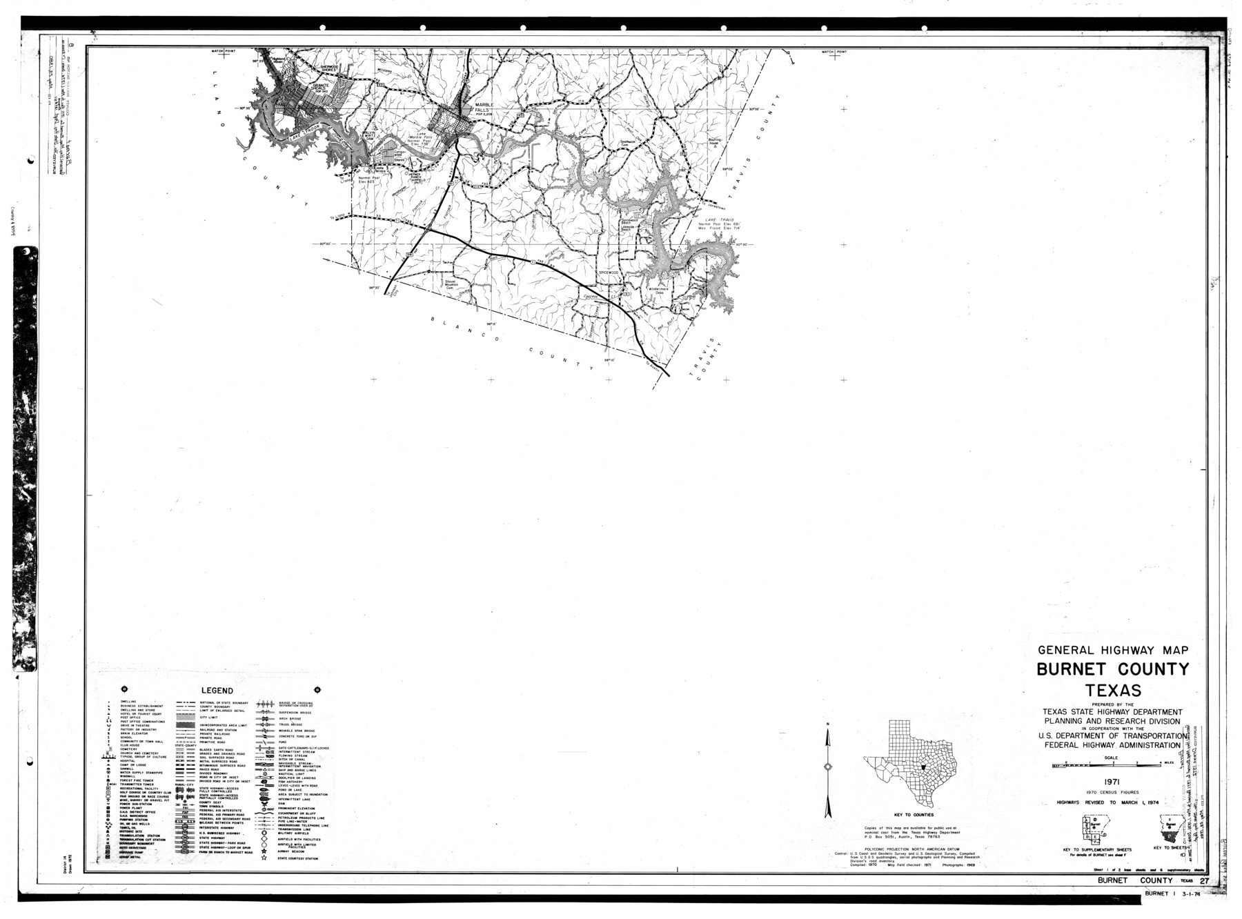
Burnet County Rolled Sketch 8
General Highway Map, Burnet County, Texas
-
Map/Doc
8554
-
Collection
General Map Collection
-
Object Dates
1971 (Creation Date)
5/23/1980 (File Date)
3/1/1974 (Revision Date)
-
People and Organizations
Texas State Highway Department (Publisher)
-
Counties
Burnet
-
Subjects
County Surveying Rolled Sketch
-
Height x Width
36.9 x 49.9 inches
93.7 x 126.8 cm
-
Medium
mylar, print
Part of: General Map Collection
Ellis County Sketch File 4

Print $4.00
- Digital $50.00
Ellis County Sketch File 4
1859
Size 13.0 x 8.5 inches
Map/Doc 21832

Map of Sabine County

Print $20.00
- Digital $50.00
Map of Sabine County
1896
Size 25.8 x 17.9 inches
Map/Doc 63012
Map of Matagorda Bay and County, with the adjacent country

Print $20.00
- Digital $50.00
Map of Matagorda Bay and County, with the adjacent country
1846
Size 18.3 x 26.0 inches
Map/Doc 72765
Map of Hall County

Print $20.00
- Digital $50.00
Map of Hall County
1900
Size 41.2 x 41.3 inches
Map/Doc 16842
Cooke County Working Sketch 11

Print $20.00
- Digital $50.00
Cooke County Working Sketch 11
1940
Size 42.6 x 28.2 inches
Map/Doc 68248
Midland County Boundary File 5

Print $6.00
- Digital $50.00
Midland County Boundary File 5
Size 9.6 x 6.0 inches
Map/Doc 57195
El Paso County Working Sketch 32

Print $20.00
- Digital $50.00
El Paso County Working Sketch 32
1971
Size 40.2 x 38.3 inches
Map/Doc 69054
Bandera County Working Sketch 28

Print $20.00
- Digital $50.00
Bandera County Working Sketch 28
1953
Size 24.8 x 19.5 inches
Map/Doc 67624
Webb County Sketch File 50

Print $20.00
- Digital $50.00
Webb County Sketch File 50
1939
Size 27.4 x 18.6 inches
Map/Doc 12648
Gonzales County Sketch File 4

Print $4.00
- Digital $50.00
Gonzales County Sketch File 4
Size 12.6 x 8.0 inches
Map/Doc 24373
Starr County Working Sketch 22

Print $20.00
- Digital $50.00
Starr County Working Sketch 22
1983
Size 25.8 x 33.1 inches
Map/Doc 63938
You may also like
Gaines County Rolled Sketch 16

Print $40.00
- Digital $50.00
Gaines County Rolled Sketch 16
1940
Size 51.2 x 36.0 inches
Map/Doc 9039
Nueces County Rolled Sketch 27B

Print $108.00
- Digital $50.00
Nueces County Rolled Sketch 27B
1948
Size 9.8 x 15.1 inches
Map/Doc 47604
[Marion County, Texas]
![75777, [Marion County, Texas], Maddox Collection](https://historictexasmaps.com/wmedia_w700/maps/75777.tif.jpg)
Print $20.00
- Digital $50.00
[Marion County, Texas]
1901
Size 26.5 x 24.1 inches
Map/Doc 75777
Jefferson County NRC Article 33.136 Sketch 12

Print $22.00
- Digital $50.00
Jefferson County NRC Article 33.136 Sketch 12
2017
Size 24.0 x 36.0 inches
Map/Doc 95055
San Patricio County Rolled Sketch 46F

Print $4.00
- Digital $50.00
San Patricio County Rolled Sketch 46F
1983
Size 18.0 x 23.1 inches
Map/Doc 8377
Map of Africa designed to accompany Smith's Geography for Schools

Print $20.00
- Digital $50.00
Map of Africa designed to accompany Smith's Geography for Schools
1850
Size 9.7 x 12.0 inches
Map/Doc 93897
Presidio County Sketch File 69b

Print $6.00
- Digital $50.00
Presidio County Sketch File 69b
1919
Size 11.2 x 8.8 inches
Map/Doc 34666
Anderson County Working Sketch 31

Print $20.00
- Digital $50.00
Anderson County Working Sketch 31
1966
Size 18.3 x 23.2 inches
Map/Doc 67031
Flight Mission No. CUG-1P, Frame 47, Kleberg County

Print $20.00
- Digital $50.00
Flight Mission No. CUG-1P, Frame 47, Kleberg County
1956
Size 18.7 x 22.4 inches
Map/Doc 86125
Robertson County Sketch File 1

Print $7.00
- Digital $50.00
Robertson County Sketch File 1
1857
Size 12.8 x 8.2 inches
Map/Doc 35340
Washington County

Print $20.00
- Digital $50.00
Washington County
1976
Size 30.4 x 45.6 inches
Map/Doc 77451
La Salle County Working Sketch 34

Print $20.00
- Digital $50.00
La Salle County Working Sketch 34
1956
Size 18.8 x 26.2 inches
Map/Doc 70335