San Patricio County Rolled Sketch 46F
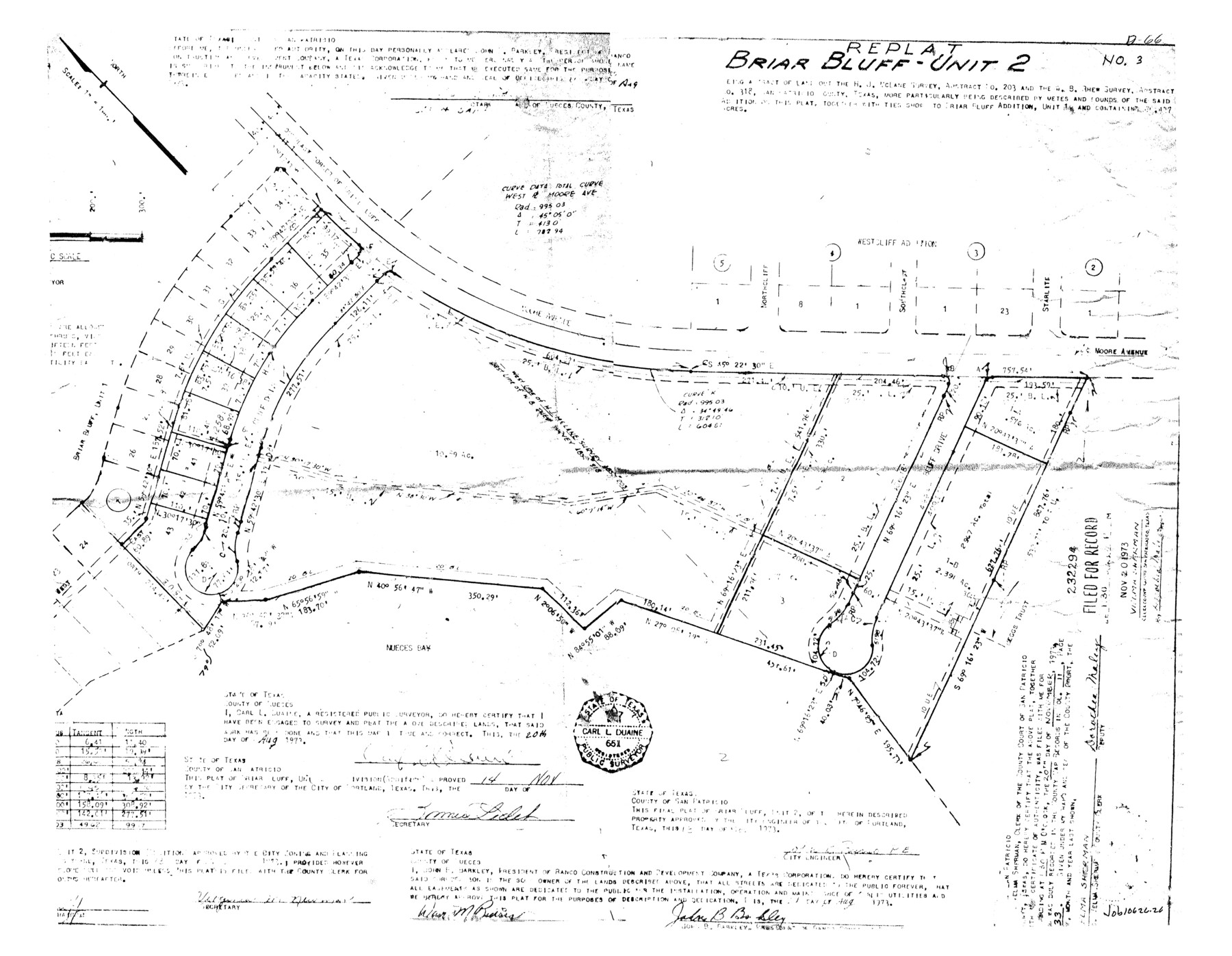
Boundary Survey of 15.97 Acres Being a Portion of 10.89 Acre Tract and All Lots 1B, 2 & 3, Replat of Briar Bluff Unit 2, San Patricio County, Texas
-
Map/Doc
8377
-
Collection
General Map Collection
-
Object Dates
1983/5/5 (Creation Date)
1983/12/5 (File Date)
-
People and Organizations
George M. Pyle (Surveyor/Engineer)
-
Counties
San Patricio
-
Subjects
Surveying Rolled Sketch
-
Height x Width
18.0 x 23.1 inches
45.7 x 58.7 cm
Part of: General Map Collection
Flight Mission No. DQN-1K, Frame 153, Calhoun County

Print $20.00
- Digital $50.00
Flight Mission No. DQN-1K, Frame 153, Calhoun County
1953
Size 18.6 x 22.3 inches
Map/Doc 84212
Culberson County Working Sketch 39

Print $40.00
- Digital $50.00
Culberson County Working Sketch 39
1966
Size 37.9 x 82.7 inches
Map/Doc 68492
Swisher County Working Sketch Graphic Index

Print $20.00
- Digital $50.00
Swisher County Working Sketch Graphic Index
1941
Size 41.5 x 35.9 inches
Map/Doc 76707
Mills County Boundary File 7

Print $2.00
- Digital $50.00
Mills County Boundary File 7
Size 14.2 x 8.6 inches
Map/Doc 57312
Blanco County Working Sketch 15

Print $20.00
- Digital $50.00
Blanco County Working Sketch 15
1950
Size 23.5 x 20.7 inches
Map/Doc 67375
Presidio County Sketch File 101

Print $20.00
- Digital $50.00
Presidio County Sketch File 101
1888
Size 21.1 x 20.3 inches
Map/Doc 11725
Williamson County Working Sketch Graphic Index

Print $40.00
- Digital $50.00
Williamson County Working Sketch Graphic Index
1946
Size 38.4 x 55.7 inches
Map/Doc 76742
Harris County Sketch File 14

Print $20.00
- Digital $50.00
Harris County Sketch File 14
Size 17.4 x 18.4 inches
Map/Doc 11649
Menard County Boundary File 4

Print $12.00
- Digital $50.00
Menard County Boundary File 4
Size 10.9 x 8.6 inches
Map/Doc 57076

Harris County Sketch File 78

Print $32.00
- Digital $50.00
Harris County Sketch File 78
1955
Size 8.7 x 9.0 inches
Map/Doc 25549
Pecos County Rolled Sketch DK3

Print $20.00
- Digital $50.00
Pecos County Rolled Sketch DK3
1938
Size 35.3 x 42.3 inches
Map/Doc 9715
You may also like

Freestone County Sketch File 8

Print $4.00
- Digital $50.00
Freestone County Sketch File 8
1859
Size 5.8 x 8.1 inches
Map/Doc 23054
Montague County Working Sketch 39

Print $20.00
- Digital $50.00
Montague County Working Sketch 39
1994
Size 34.4 x 45.0 inches
Map/Doc 71105
Val Verde County Working Sketch 103

Print $20.00
- Digital $50.00
Val Verde County Working Sketch 103
1981
Size 37.1 x 39.9 inches
Map/Doc 72238
Old Miscellaneous File 29

Print $4.00
- Digital $50.00
Old Miscellaneous File 29
1838
Size 7.4 x 12.5 inches
Map/Doc 75738
Red River County Rolled Sketch 2

Print $20.00
- Digital $50.00
Red River County Rolled Sketch 2
Size 33.3 x 28.4 inches
Map/Doc 7471
The Mexican Department of Brazos. Created, March 18, 1834

Print $20.00
The Mexican Department of Brazos. Created, March 18, 1834
2020
Size 19.7 x 21.7 inches
Map/Doc 95975
Flight Mission No. DQN-2K, Frame 28, Calhoun County

Print $20.00
- Digital $50.00
Flight Mission No. DQN-2K, Frame 28, Calhoun County
1953
Size 18.6 x 22.2 inches
Map/Doc 84235
Flight Mission No. BRE-2P, Frame 99, Nueces County

Print $20.00
- Digital $50.00
Flight Mission No. BRE-2P, Frame 99, Nueces County
1956
Size 18.5 x 22.3 inches
Map/Doc 86784
Reagan County Sketch File 24

Print $6.00
- Digital $50.00
Reagan County Sketch File 24
1940
Size 11.4 x 8.7 inches
Map/Doc 35018
[North half Dawson County, southwest quarter Lynn County, south half of Terry County, southeast quarter Yoakum County, north half Gaines County]
![93133, [North half Dawson County, southwest quarter Lynn County, south half of Terry County, southeast quarter Yoakum County, north half Gaines County], Twichell Survey Records](https://historictexasmaps.com/wmedia_w700/maps/93133-1.tif.jpg)
Print $40.00
- Digital $50.00
[North half Dawson County, southwest quarter Lynn County, south half of Terry County, southeast quarter Yoakum County, north half Gaines County]
Size 79.8 x 45.3 inches
Map/Doc 93133
Flight Mission No. CRC-3R, Frame 29, Chambers County

Print $20.00
- Digital $50.00
Flight Mission No. CRC-3R, Frame 29, Chambers County
1956
Size 18.6 x 22.3 inches
Map/Doc 84804