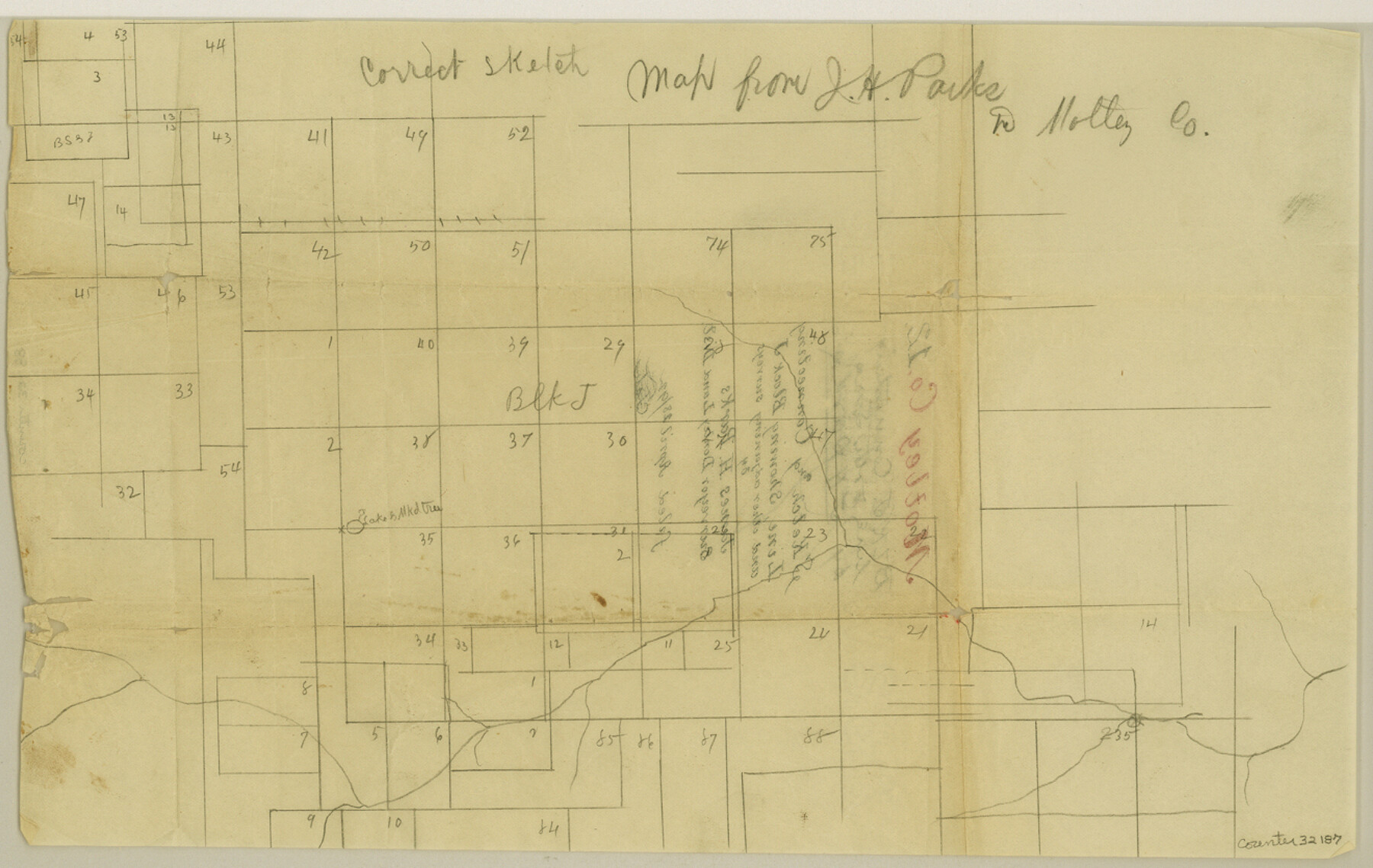
Motley County Sketch File 12 (S)
[Sketch and connecting line showing Block J and other adjoining surveys]
-
Map/Doc
32187
-
Collection
General Map Collection
-
Object Dates
4/28/1892 (File Date)
-
People and Organizations
James H. Parks (Surveyor/Engineer)
-
Counties
Motley Dickens
-
Subjects
Surveying Sketch File
-
Height x Width
8.4 x 13.2 inches
21.3 x 33.5 cm
-
Medium
paper, manuscript
Part of: General Map Collection

Travis County Sketch File 21

Print $4.00
- Digital $50.00
Travis County Sketch File 21
1875
Size 12.8 x 8.4 inches
Map/Doc 38325
Austin County Sketch File 4a

Print $8.00
- Digital $50.00
Austin County Sketch File 4a
1881
Size 6.5 x 4.9 inches
Map/Doc 13861
Jefferson County Rolled Sketch 40

Print $20.00
- Digital $50.00
Jefferson County Rolled Sketch 40
1957
Size 22.6 x 36.7 inches
Map/Doc 6398
Burleson County

Print $20.00
- Digital $50.00
Burleson County
1884
Size 18.2 x 23.4 inches
Map/Doc 3347
Rusk County Working Sketch 38

Print $20.00
- Digital $50.00
Rusk County Working Sketch 38
2008
Size 16.3 x 23.3 inches
Map/Doc 88815
No. 2 Chart of Corpus Christi Pass, Texas

Print $20.00
- Digital $50.00
No. 2 Chart of Corpus Christi Pass, Texas
1878
Size 18.3 x 27.4 inches
Map/Doc 73022
[Galveston, Harrisburg & San Antonio from El Paso-Presidio county boundary to Presidio-Pecos county boundary]
![64716, [Galveston, Harrisburg & San Antonio from El Paso-Presidio county boundary to Presidio-Pecos county boundary], General Map Collection](https://historictexasmaps.com/wmedia_w700/maps/64716.tif.jpg)
Print $40.00
- Digital $50.00
[Galveston, Harrisburg & San Antonio from El Paso-Presidio county boundary to Presidio-Pecos county boundary]
Size 124.4 x 45.3 inches
Map/Doc 64716
Hidalgo County Working Sketch 7

Print $40.00
- Digital $50.00
Hidalgo County Working Sketch 7
1963
Size 26.4 x 73.9 inches
Map/Doc 66184
Dallam County

Print $40.00
- Digital $50.00
Dallam County
1901
Size 44.3 x 56.3 inches
Map/Doc 93459
Hockley County Working Sketch 2

Print $20.00
- Digital $50.00
Hockley County Working Sketch 2
1960
Size 17.8 x 35.7 inches
Map/Doc 66192
Chambers County Sketch File 18b

Print $15.00
- Digital $50.00
Chambers County Sketch File 18b
1901
Size 9.2 x 8.1 inches
Map/Doc 17571
You may also like
McMullen County Working Sketch 19

Print $20.00
- Digital $50.00
McMullen County Working Sketch 19
1944
Size 26.1 x 29.2 inches
Map/Doc 70720
[Coleman and McCullogh County Drilling Block]
![92968, [Coleman and McCullogh County Drilling Block], Twichell Survey Records](https://historictexasmaps.com/wmedia_w700/maps/92968-1.tif.jpg)
Print $20.00
- Digital $50.00
[Coleman and McCullogh County Drilling Block]
Size 16.6 x 18.6 inches
Map/Doc 92968
Flight Mission No. DQO-8K, Frame 145, Galveston County

Print $20.00
- Digital $50.00
Flight Mission No. DQO-8K, Frame 145, Galveston County
1952
Size 18.6 x 22.5 inches
Map/Doc 85207
Matagorda County Sketch File 42

Print $38.00
- Digital $50.00
Matagorda County Sketch File 42
1912
Size 14.2 x 8.8 inches
Map/Doc 30834
The Chief Justice County of Washington. Lands in Conflict with Nacogdoches County

Print $20.00
The Chief Justice County of Washington. Lands in Conflict with Nacogdoches County
2020
Size 13.0 x 21.7 inches
Map/Doc 96078
San Jacinto River and Tributaries, Texas - Survey of 1939

Print $20.00
- Digital $50.00
San Jacinto River and Tributaries, Texas - Survey of 1939
1939
Size 27.7 x 40.4 inches
Map/Doc 60306
Matagorda County Working Sketch 28

Print $3.00
- Digital $50.00
Matagorda County Working Sketch 28
1980
Size 10.7 x 12.1 inches
Map/Doc 70886
Presidio County Rolled Sketch 112

Print $20.00
- Digital $50.00
Presidio County Rolled Sketch 112
1972
Size 22.8 x 36.5 inches
Map/Doc 7388
Kimble County Working Sketch 35

Print $20.00
- Digital $50.00
Kimble County Working Sketch 35
1946
Size 24.7 x 32.0 inches
Map/Doc 70103
[Surveys along the Cibolo, Balcones and Leon Creeks]
![37, [Surveys along the Cibolo, Balcones and Leon Creeks], General Map Collection](https://historictexasmaps.com/wmedia_w700/maps/37.tif.jpg)
Print $2.00
- Digital $50.00
[Surveys along the Cibolo, Balcones and Leon Creeks]
1841
Size 13.3 x 7.8 inches
Map/Doc 37
Anderson County Working Sketch 31

Print $20.00
- Digital $50.00
Anderson County Working Sketch 31
1966
Size 18.3 x 23.2 inches
Map/Doc 67031
Blanco County Sketch File 36

Print $8.00
- Digital $50.00
Blanco County Sketch File 36
1889
Size 11.2 x 8.8 inches
Map/Doc 14642