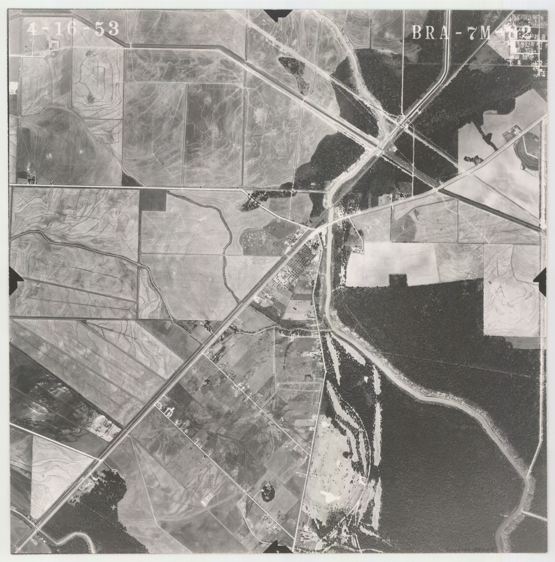
Flight Mission No. BRA-7M, Frame 82, Jefferson County
BRA-7M-82
-
Map/Doc
85504
-
Collection
General Map Collection
-
Object Dates
1953/4/16 (Creation Date)
-
People and Organizations
U. S. Department of Agriculture (Publisher)
-
Counties
Jefferson
-
Subjects
Aerial Photograph
-
Height x Width
16.1 x 15.9 inches
40.9 x 40.4 cm
-
Comments
Flown by Jack Ammann Photogrammetric Engineers of San Antonio, Texas.
Part of: General Map Collection
Jeff Davis County Rolled Sketch 46

Print $134.00
- Digital $50.00
Jeff Davis County Rolled Sketch 46
2006
Size 17.5 x 24.0 inches
Map/Doc 87213
Polk County Sketch File 25

Print $46.00
- Digital $50.00
Polk County Sketch File 25
Size 5.7 x 28.2 inches
Map/Doc 34176
Winkler County Working Sketch 7

Print $20.00
- Digital $50.00
Winkler County Working Sketch 7
1958
Size 45.4 x 30.2 inches
Map/Doc 72601
Travis County Sketch File 68

Print $20.00
- Digital $50.00
Travis County Sketch File 68
1949
Size 24.9 x 26.0 inches
Map/Doc 12475
El Paso County State Real Property Sketch 3

Print $20.00
- Digital $50.00
El Paso County State Real Property Sketch 3
2012
Size 25.1 x 36.4 inches
Map/Doc 93700
Presidio County Rolled Sketch 41

Print $20.00
- Digital $50.00
Presidio County Rolled Sketch 41
1907
Size 20.7 x 25.0 inches
Map/Doc 7338
Anderson County Working Sketch 35

Print $20.00
- Digital $50.00
Anderson County Working Sketch 35
1968
Size 26.1 x 22.4 inches
Map/Doc 67035
Upton County Sketch File S

Print $8.00
- Digital $50.00
Upton County Sketch File S
Size 13.4 x 9.1 inches
Map/Doc 38850
Galveston County Sketch File 68

Print $62.00
- Digital $50.00
Galveston County Sketch File 68
Size 4.4 x 9.7 inches
Map/Doc 23784
Midland County Rolled Sketch 6

Print $20.00
- Digital $50.00
Midland County Rolled Sketch 6
1951
Size 39.8 x 28.6 inches
Map/Doc 6764
Edwards County Working Sketch 133

Print $20.00
- Digital $50.00
Edwards County Working Sketch 133
1985
Size 29.7 x 38.9 inches
Map/Doc 69009
Hamilton County Rolled Sketch 11

Print $20.00
- Digital $50.00
Hamilton County Rolled Sketch 11
Size 20.1 x 14.1 inches
Map/Doc 6060
You may also like
Nacogdoches County Working Sketch 8

Print $20.00
- Digital $50.00
Nacogdoches County Working Sketch 8
1964
Size 28.0 x 22.7 inches
Map/Doc 71224
Lavaca County Rolled Sketch 3

Print $20.00
- Digital $50.00
Lavaca County Rolled Sketch 3
1959
Size 42.8 x 32.8 inches
Map/Doc 9419
Polk County Sketch File 39

Print $24.00
- Digital $50.00
Polk County Sketch File 39
Size 8.3 x 13.3 inches
Map/Doc 34278
Hall County Sketch File 33

Print $16.00
- Digital $50.00
Hall County Sketch File 33
1912
Size 11.4 x 8.7 inches
Map/Doc 24874
Presidio County Working Sketch 7

Print $20.00
- Digital $50.00
Presidio County Working Sketch 7
1926
Size 35.0 x 40.0 inches
Map/Doc 71681
Dimmit County Sketch File 46

Print $32.00
- Digital $50.00
Dimmit County Sketch File 46
1905
Size 3.9 x 9.0 inches
Map/Doc 21172
Sketch in Cochran County, Texas

Print $20.00
- Digital $50.00
Sketch in Cochran County, Texas
1949
Size 21.8 x 21.0 inches
Map/Doc 92495

Panola County Working Sketch 34

Print $20.00
- Digital $50.00
Panola County Working Sketch 34
1983
Map/Doc 71443
Kendall County Sketch File 11

Print $8.00
- Digital $50.00
Kendall County Sketch File 11
1924
Size 11.2 x 8.7 inches
Map/Doc 28695
Denton County Rolled Sketch 4

Print $20.00
- Digital $50.00
Denton County Rolled Sketch 4
1973
Size 22.7 x 39.3 inches
Map/Doc 5701
Dimmit County Boundary File 6a

Print $6.00
- Digital $50.00
Dimmit County Boundary File 6a
Size 8.9 x 3.9 inches
Map/Doc 52587