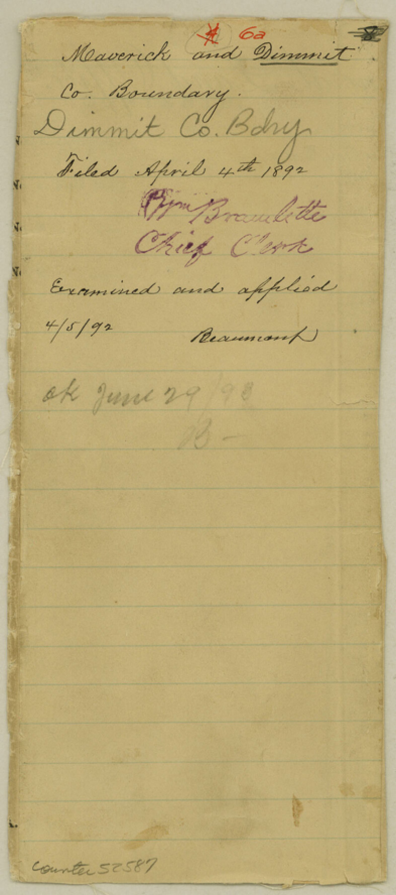
Dimmit County Boundary File 6a
West Boundary of Dimmit and Maverick Co. Boundary Field Notes
-
Map/Doc
52587
-
Collection
General Map Collection
-
Counties
Dimmit
-
Subjects
County Boundaries
-
Height x Width
8.9 x 3.9 inches
22.6 x 9.9 cm
Part of: General Map Collection
Central & Montgomery

Print $40.00
- Digital $50.00
Central & Montgomery
1941
Size 26.1 x 123.0 inches
Map/Doc 64523

Edwards County Sketch File 43

Print $20.00
- Digital $50.00
Edwards County Sketch File 43
1947
Size 17.4 x 18.2 inches
Map/Doc 11441
Atascosa County Working Sketch 22

Print $20.00
- Digital $50.00
Atascosa County Working Sketch 22
1956
Size 31.6 x 25.5 inches
Map/Doc 67218
Mills County Sketch File 17

Print $10.00
- Digital $50.00
Mills County Sketch File 17
1912
Size 14.4 x 8.8 inches
Map/Doc 31665
Hudspeth County Working Sketch 54

Print $20.00
- Digital $50.00
Hudspeth County Working Sketch 54
1989
Size 18.8 x 36.2 inches
Map/Doc 66339
Fort Bend County Sketch File 31

Print $10.00
- Digital $50.00
Fort Bend County Sketch File 31
1940
Size 13.3 x 8.7 inches
Map/Doc 22997
General Chart of the Coast No. XXI Gulf Coast from Galveston to the Rio Grande

Print $20.00
- Digital $50.00
General Chart of the Coast No. XXI Gulf Coast from Galveston to the Rio Grande
1883
Size 26.7 x 18.2 inches
Map/Doc 72727
Crockett County Sketch File 9

Print $12.00
- Digital $50.00
Crockett County Sketch File 9
1881
Size 9.0 x 10.0 inches
Map/Doc 19655
Buchanan Dam Reservoir Clearing

Print $20.00
- Digital $50.00
Buchanan Dam Reservoir Clearing
1935
Size 21.8 x 40.4 inches
Map/Doc 60393
Trinity County Sketch File 22

Print $23.00
- Digital $50.00
Trinity County Sketch File 22
1877
Size 9.4 x 12.3 inches
Map/Doc 38550
Val Verde County Rolled Sketch 40

Print $40.00
- Digital $50.00
Val Verde County Rolled Sketch 40
Size 39.0 x 123.5 inches
Map/Doc 10073
You may also like
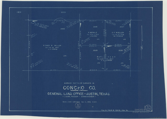
Concho County Working Sketch 16
Print $20.00
- Digital $50.00
Concho County Working Sketch 16
1956
Size 14.9 x 20.7 inches
Map/Doc 68198
Bowie County Working Sketch 27

Print $20.00
- Digital $50.00
Bowie County Working Sketch 27
1987
Size 39.1 x 33.8 inches
Map/Doc 67431
Flight Mission No. DAG-24K, Frame 140, Matagorda County

Print $20.00
- Digital $50.00
Flight Mission No. DAG-24K, Frame 140, Matagorda County
1953
Size 17.0 x 15.6 inches
Map/Doc 86558
Bexar County Sketch File 11

Print $2.00
- Digital $50.00
Bexar County Sketch File 11
Size 8.3 x 9.5 inches
Map/Doc 14481
Galveston County Working Sketch 1

Print $20.00
- Digital $50.00
Galveston County Working Sketch 1
Size 27.7 x 33.7 inches
Map/Doc 69338
Garza County Rolled Sketch 14

Print $41.00
- Digital $50.00
Garza County Rolled Sketch 14
1913
Size 10.0 x 15.2 inches
Map/Doc 45234
Atascosa County Working Sketch 4

Print $20.00
- Digital $50.00
Atascosa County Working Sketch 4
1913
Size 16.8 x 15.0 inches
Map/Doc 67199
Colorado County Working Sketch 34

Print $20.00
- Digital $50.00
Colorado County Working Sketch 34
1988
Size 26.9 x 23.9 inches
Map/Doc 68134
Johnson County Working Sketch 15

Print $20.00
- Digital $50.00
Johnson County Working Sketch 15
1974
Size 21.6 x 23.8 inches
Map/Doc 66628
[Miller Day Ranch]
![81517, [Miller Day Ranch], General Map Collection](https://historictexasmaps.com/wmedia_w700/maps/81517.tif.jpg)
Print $40.00
- Digital $50.00
[Miller Day Ranch]
1995
Size 60.6 x 38.0 inches
Map/Doc 81517
Crockett County Working Sketch 57

Print $20.00
- Digital $50.00
Crockett County Working Sketch 57
1954
Size 35.9 x 38.8 inches
Map/Doc 68390
Henderson County

Print $40.00
- Digital $50.00
Henderson County
1922
Size 33.0 x 62.7 inches
Map/Doc 66861