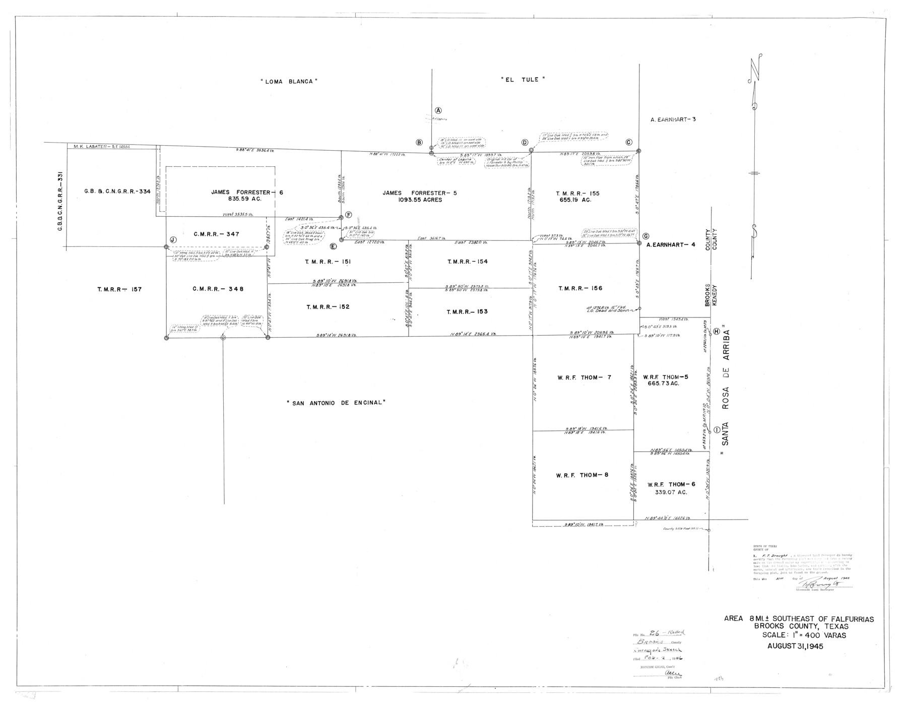
Brooks County Rolled Sketch 26
Area 8 Mi. southeast of Falfurrias
-
Map/Doc
8539
-
Collection
General Map Collection
-
Object Dates
1945/8/31 (Creation Date)
1946/2/2 (File Date)
-
People and Organizations
F.T. Drought (Surveyor/Engineer)
-
Counties
Brooks
-
Subjects
Surveying Rolled Sketch
-
Height x Width
33.7 x 43.3 inches
85.6 x 110.0 cm
-
Medium
blueprint/diazo
-
Scale
1" = 400 varas
-
Comments
See SF 8724 for surveyor's statement.
Part of: General Map Collection
Liberty County Sketch File 62

Print $8.00
- Digital $50.00
Liberty County Sketch File 62
1953
Size 14.1 x 8.7 inches
Map/Doc 30083

Chambers County Working Sketch 6

Print $20.00
- Digital $50.00
Chambers County Working Sketch 6
1938
Size 14.3 x 19.7 inches
Map/Doc 67989
Lampasas County Boundary File 4a

Print $12.00
- Digital $50.00
Lampasas County Boundary File 4a
Size 12.8 x 8.2 inches
Map/Doc 56122
Hidalgo County Working Sketch 2

Print $20.00
- Digital $50.00
Hidalgo County Working Sketch 2
1906
Size 22.0 x 28.0 inches
Map/Doc 66179
Titus County Sketch File 3

Print $40.00
- Digital $50.00
Titus County Sketch File 3
1852
Size 19.9 x 8.4 inches
Map/Doc 38134
Cameron County Rolled Sketch 20A

Print $20.00
- Digital $50.00
Cameron County Rolled Sketch 20A
Size 12.5 x 23.1 inches
Map/Doc 5471
Hidalgo County Sketch File 17

Print $6.00
- Digital $50.00
Hidalgo County Sketch File 17
1950
Size 14.5 x 8.8 inches
Map/Doc 26443
Sabine River, Toll Bridge Sheet

Print $40.00
- Digital $50.00
Sabine River, Toll Bridge Sheet
1933
Size 27.8 x 51.9 inches
Map/Doc 65136
Yoakum County Sketch File 20

Print $22.00
- Digital $50.00
Yoakum County Sketch File 20
1977
Size 13.1 x 14.5 inches
Map/Doc 40841
Galveston Bay and Approaches

Print $20.00
- Digital $50.00
Galveston Bay and Approaches
1946
Size 45.5 x 34.0 inches
Map/Doc 69876
Mitchell County Sketch File 12

Print $20.00
- Digital $50.00
Mitchell County Sketch File 12
1912
Size 25.6 x 14.0 inches
Map/Doc 12099
You may also like
Flight Mission No. DIX-6P, Frame 183, Aransas County

Print $20.00
- Digital $50.00
Flight Mission No. DIX-6P, Frame 183, Aransas County
1956
Size 19.1 x 22.7 inches
Map/Doc 83845
Kent County Working Sketch Graphic Index

Print $20.00
- Digital $50.00
Kent County Working Sketch Graphic Index
1971
Size 44.7 x 37.0 inches
Map/Doc 76604
[Sketch showing west part of county]
![91712, [Sketch showing west part of county], Twichell Survey Records](https://historictexasmaps.com/wmedia_w700/maps/91712-1.tif.jpg)
Print $3.00
- Digital $50.00
[Sketch showing west part of county]
1907
Size 16.4 x 11.1 inches
Map/Doc 91712
Atascosa County Working Sketch 1a

Print $20.00
- Digital $50.00
Atascosa County Working Sketch 1a
1908
Size 35.8 x 40.2 inches
Map/Doc 67194
Medina County Sketch File 18

Print $40.00
- Digital $50.00
Medina County Sketch File 18
Size 23.1 x 10.5 inches
Map/Doc 31482
Brazos County Sketch File 1

Print $4.00
- Digital $50.00
Brazos County Sketch File 1
1858
Size 10.4 x 7.6 inches
Map/Doc 15550
[I. & G. N. Sections 11, 12, and 13]
![91038, [I. & G. N. Sections 11, 12, and 13], Twichell Survey Records](https://historictexasmaps.com/wmedia_w700/maps/91038-1.tif.jpg)
Print $20.00
- Digital $50.00
[I. & G. N. Sections 11, 12, and 13]
Size 28.9 x 11.5 inches
Map/Doc 91038
Tarrant County Working Sketch 18

Print $20.00
- Digital $50.00
Tarrant County Working Sketch 18
1996
Size 20.4 x 18.5 inches
Map/Doc 62435
Val Verde County Sketch File Z3

Print $12.00
- Digital $50.00
Val Verde County Sketch File Z3
Size 8.8 x 7.8 inches
Map/Doc 39131
Edwards County Boundary File 28

Print $50.00
- Digital $50.00
Edwards County Boundary File 28
Size 12.9 x 5.2 inches
Map/Doc 52932
Hudspeth County Rolled Sketch 26

Print $20.00
- Digital $50.00
Hudspeth County Rolled Sketch 26
1909
Size 19.3 x 18.0 inches
Map/Doc 6247
Johnson County Sketch File 1

Print $48.00
- Digital $50.00
Johnson County Sketch File 1
Size 8.0 x 6.9 inches
Map/Doc 28427