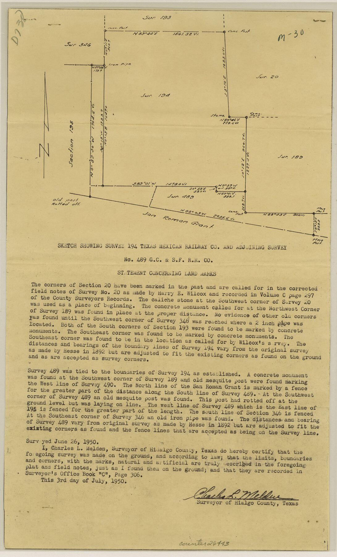
Hidalgo County Sketch File 17
[Sketch and report of surveys 194 and 192]
-
Map/Doc
26443
-
Collection
General Map Collection
-
Object Dates
7/3/1950 (Creation Date)
7/13/1950 (File Date)
1892 (Survey Date)
6/26/1950 (Survey Date)
8/20/1924 (Survey Date)
12/5/1938 (Survey Date)
6/20/1950 (Survey Date)
-
People and Organizations
Charles L. Melden (Surveyor/Engineer)
Harry E. Wilcox (Surveyor/Engineer)
Hesse (Surveyor/Engineer)
Parks (Surveyor/Engineer)
Hayes Dix (Surveyor/Engineer)
-
Counties
Hidalgo
-
Subjects
Surveying Sketch File
-
Height x Width
14.5 x 8.8 inches
36.8 x 22.4 cm
-
Medium
paper, print
Part of: General Map Collection
Trinity County Sketch File 27

Print $4.00
- Digital $50.00
Trinity County Sketch File 27
Size 12.0 x 8.6 inches
Map/Doc 38562
Polk County Working Sketch 20

Print $40.00
- Digital $50.00
Polk County Working Sketch 20
1952
Size 42.2 x 51.7 inches
Map/Doc 71635
In the Supreme Court of the United States The State of Oklahoma, Complainant vs. The State of Texas, Defendant, The United States of America, Intervener - 1920

Print $20.00
- Digital $50.00
In the Supreme Court of the United States The State of Oklahoma, Complainant vs. The State of Texas, Defendant, The United States of America, Intervener - 1920
1920
Size 32.4 x 36.8 inches
Map/Doc 75129
Calcasieu Pass to Sabine Pass
Print $20.00
- Digital $50.00
Calcasieu Pass to Sabine Pass
1946
Size 44.7 x 35.7 inches
Map/Doc 69806
Val Verde County Working Sketch 68

Print $20.00
- Digital $50.00
Val Verde County Working Sketch 68
1965
Size 37.3 x 44.2 inches
Map/Doc 72203
Map of Lampasas County

Print $40.00
- Digital $50.00
Map of Lampasas County
1900
Size 47.1 x 60.2 inches
Map/Doc 62971
Township No. 1 North Range No. 26 West of the Indian Meridian

Print $20.00
- Digital $50.00
Township No. 1 North Range No. 26 West of the Indian Meridian
1874
Size 19.3 x 24.4 inches
Map/Doc 75171
Coast Chart No. 210 Aransas Pass and Corpus Christi Bay with the coast to latitude 27° 12' Texas

Print $20.00
- Digital $50.00
Coast Chart No. 210 Aransas Pass and Corpus Christi Bay with the coast to latitude 27° 12' Texas
1887
Size 27.2 x 18.2 inches
Map/Doc 72801
St. Louis, Brownsville & Mexico

Print $40.00
- Digital $50.00
St. Louis, Brownsville & Mexico
1906
Size 21.2 x 130.5 inches
Map/Doc 89280
Flight Mission No. CRC-4R, Frame 148, Chambers County

Print $20.00
- Digital $50.00
Flight Mission No. CRC-4R, Frame 148, Chambers County
1956
Size 18.7 x 22.4 inches
Map/Doc 84911
Childress County Sketch File 15a

Print $4.00
- Digital $50.00
Childress County Sketch File 15a
Size 8.6 x 11.7 inches
Map/Doc 18303
Lampasas County Sketch File 19

Print $4.00
- Digital $50.00
Lampasas County Sketch File 19
1888
Size 10.3 x 8.2 inches
Map/Doc 29432
You may also like
Pottsboro Quadrangle

Print $20.00
- Digital $50.00
Pottsboro Quadrangle
1999
Size 35.4 x 23.4 inches
Map/Doc 97363
Goliad County Sketch File 22

Print $12.00
- Digital $50.00
Goliad County Sketch File 22
1855
Size 12.8 x 8.1 inches
Map/Doc 24289
Rockwall County Boundary File 3

Print $22.00
- Digital $50.00
Rockwall County Boundary File 3
Size 14.4 x 8.7 inches
Map/Doc 58391

Flight Mission No. BQR-4K, Frame 59, Brazoria County

Print $20.00
- Digital $50.00
Flight Mission No. BQR-4K, Frame 59, Brazoria County
1952
Size 18.7 x 22.4 inches
Map/Doc 83992
Flight Mission No. BRE-1P, Frame 4, Nueces County

Print $20.00
- Digital $50.00
Flight Mission No. BRE-1P, Frame 4, Nueces County
1956
Size 18.3 x 22.2 inches
Map/Doc 86612
Comal County Sketch File 21

Print $21.00
- Digital $50.00
Comal County Sketch File 21
1950
Size 9.1 x 11.4 inches
Map/Doc 19041
Flight Mission No. DCL-6C, Frame 13, Kenedy County

Print $20.00
- Digital $50.00
Flight Mission No. DCL-6C, Frame 13, Kenedy County
1943
Size 18.6 x 22.3 inches
Map/Doc 85870
Mapa de los Estados Unidos Mejicanos arreglado a la distribucion que en diversos decretos ha hecho del territorio el Congreso General Mejicano

Print $20.00
- Digital $50.00
Mapa de los Estados Unidos Mejicanos arreglado a la distribucion que en diversos decretos ha hecho del territorio el Congreso General Mejicano
1851
Size 24.6 x 30.3 inches
Map/Doc 96514
Johnson County Working Sketch 10

Print $20.00
- Digital $50.00
Johnson County Working Sketch 10
1953
Size 26.2 x 37.1 inches
Map/Doc 66623
Aransas County Sketch File 36

Print $288.00
- Digital $50.00
Aransas County Sketch File 36
Size 8.5 x 10.9 inches
Map/Doc 13360
General Highway Map, Orange County, Texas

Print $20.00
General Highway Map, Orange County, Texas
1940
Size 18.3 x 24.5 inches
Map/Doc 79212