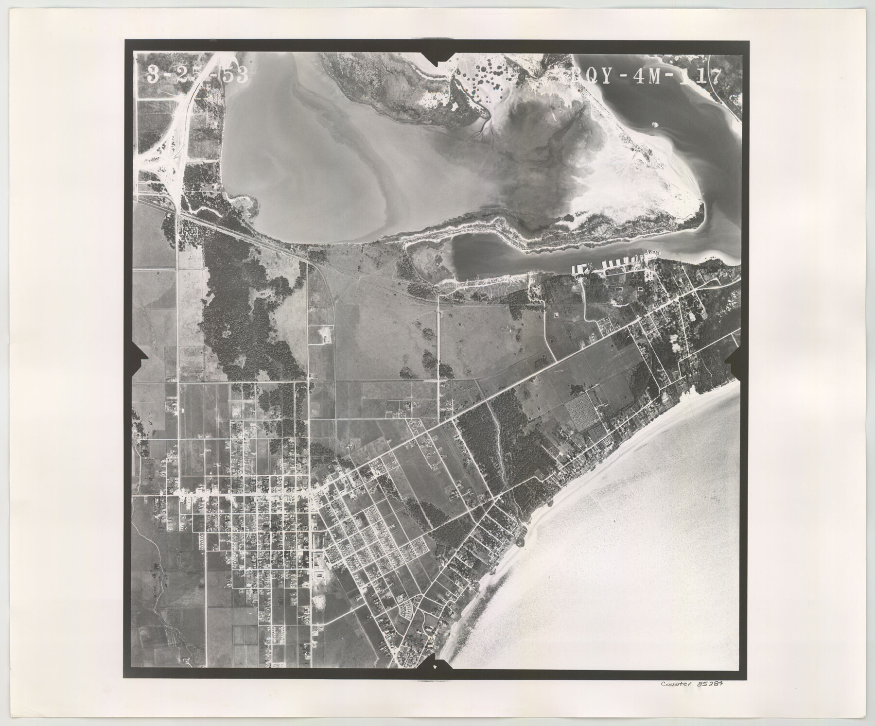
Flight Mission No. BQY-4M, Frame 117, Harris County
BQY-4M-117
-
Map/Doc
85284
-
Collection
General Map Collection
-
Object Dates
1953/3/25 (Creation Date)
-
People and Organizations
U. S. Department of Agriculture (Publisher)
-
Counties
Harris
-
Subjects
Aerial Photograph
-
Height x Width
18.5 x 22.3 inches
47.0 x 56.6 cm
-
Comments
Flown by Jack Ammann Photogrammetric Engineers of San Antonio, Texas.
Part of: General Map Collection
Traveller's Map of the State of Texas

Print $20.00
- Digital $50.00
Traveller's Map of the State of Texas
1867
Size 40.7 x 38.7 inches
Map/Doc 2130
Hudspeth County Rolled Sketch 30

Print $20.00
- Digital $50.00
Hudspeth County Rolled Sketch 30
1924
Size 36.0 x 47.3 inches
Map/Doc 9210
Webb County Sketch File 56

Print $20.00
- Digital $50.00
Webb County Sketch File 56
1940
Size 18.4 x 20.7 inches
Map/Doc 12651
Donley County Sketch File B12

Print $6.00
- Digital $50.00
Donley County Sketch File B12
1982
Size 9.1 x 14.6 inches
Map/Doc 21276
Val Verde County Sketch File Z7

Print $20.00
- Digital $50.00
Val Verde County Sketch File Z7
Size 25.6 x 17.2 inches
Map/Doc 12552
San Patricio County Sketch File 9

Print $2.00
- Digital $50.00
San Patricio County Sketch File 9
1846
Size 8.3 x 8.7 inches
Map/Doc 36039
Andrews County Working Sketch 27

Print $20.00
- Digital $50.00
Andrews County Working Sketch 27
1984
Size 19.1 x 16.2 inches
Map/Doc 67073
Wilbarger County Rolled Sketch 8

Print $20.00
- Digital $50.00
Wilbarger County Rolled Sketch 8
1965
Size 22.0 x 18.9 inches
Map/Doc 8257
Kerr County Rolled Sketch 10

Print $20.00
- Digital $50.00
Kerr County Rolled Sketch 10
1946
Size 20.7 x 26.2 inches
Map/Doc 6494
Flight Mission No. BQR-3K, Frame 153, Brazoria County

Print $20.00
- Digital $50.00
Flight Mission No. BQR-3K, Frame 153, Brazoria County
1952
Size 18.7 x 22.4 inches
Map/Doc 83980
Lynn County Working Sketch 1

Print $20.00
- Digital $50.00
Lynn County Working Sketch 1
1945
Size 17.2 x 14.0 inches
Map/Doc 70671
University Land Loving-Ward-Winkler Counties

Print $20.00
- Digital $50.00
University Land Loving-Ward-Winkler Counties
1931
Size 24.7 x 33.2 inches
Map/Doc 2448
You may also like

Go Turnpike! Dallas-Fort Worth Turnpike (Verso)

Go Turnpike! Dallas-Fort Worth Turnpike (Verso)
1963
Size 11.2 x 17.2 inches
Map/Doc 94178
Brazoria County, Texas

Print $20.00
- Digital $50.00
Brazoria County, Texas
1877
Size 24.7 x 21.7 inches
Map/Doc 425

Geological Map of the United States and the British Provinces of North America

Print $20.00
- Digital $50.00
Geological Map of the United States and the British Provinces of North America
Size 23.4 x 35.9 inches
Map/Doc 93988
Liberty County Working Sketch 59

Print $40.00
- Digital $50.00
Liberty County Working Sketch 59
1968
Size 38.1 x 87.1 inches
Map/Doc 70519
Highland Lakes 1981 in the scenic Hill Country of Central Texas

Digital $50.00
Highland Lakes 1981 in the scenic Hill Country of Central Texas
1981
Size 11.3 x 16.8 inches
Map/Doc 94174
Flight Mission No. DAH-9M, Frame 163, Orange County

Print $20.00
- Digital $50.00
Flight Mission No. DAH-9M, Frame 163, Orange County
1953
Size 18.4 x 22.4 inches
Map/Doc 86862
Crane County Sketch File 18

Print $20.00
- Digital $50.00
Crane County Sketch File 18
1927
Size 15.1 x 18.4 inches
Map/Doc 11210
[Northeast 1/4 of County]
![91629, [Northeast 1/4 of County], Twichell Survey Records](https://historictexasmaps.com/wmedia_w700/maps/91629-1.tif.jpg)
Print $2.00
- Digital $50.00
[Northeast 1/4 of County]
Size 12.3 x 9.0 inches
Map/Doc 91629
Val Verde County Sketch File B

Print $28.00
- Digital $50.00
Val Verde County Sketch File B
1897
Size 20.2 x 15.0 inches
Map/Doc 12542
Montague County Sketch File 26

Print $4.00
- Digital $50.00
Montague County Sketch File 26
1945
Size 11.3 x 8.7 inches
Map/Doc 31760