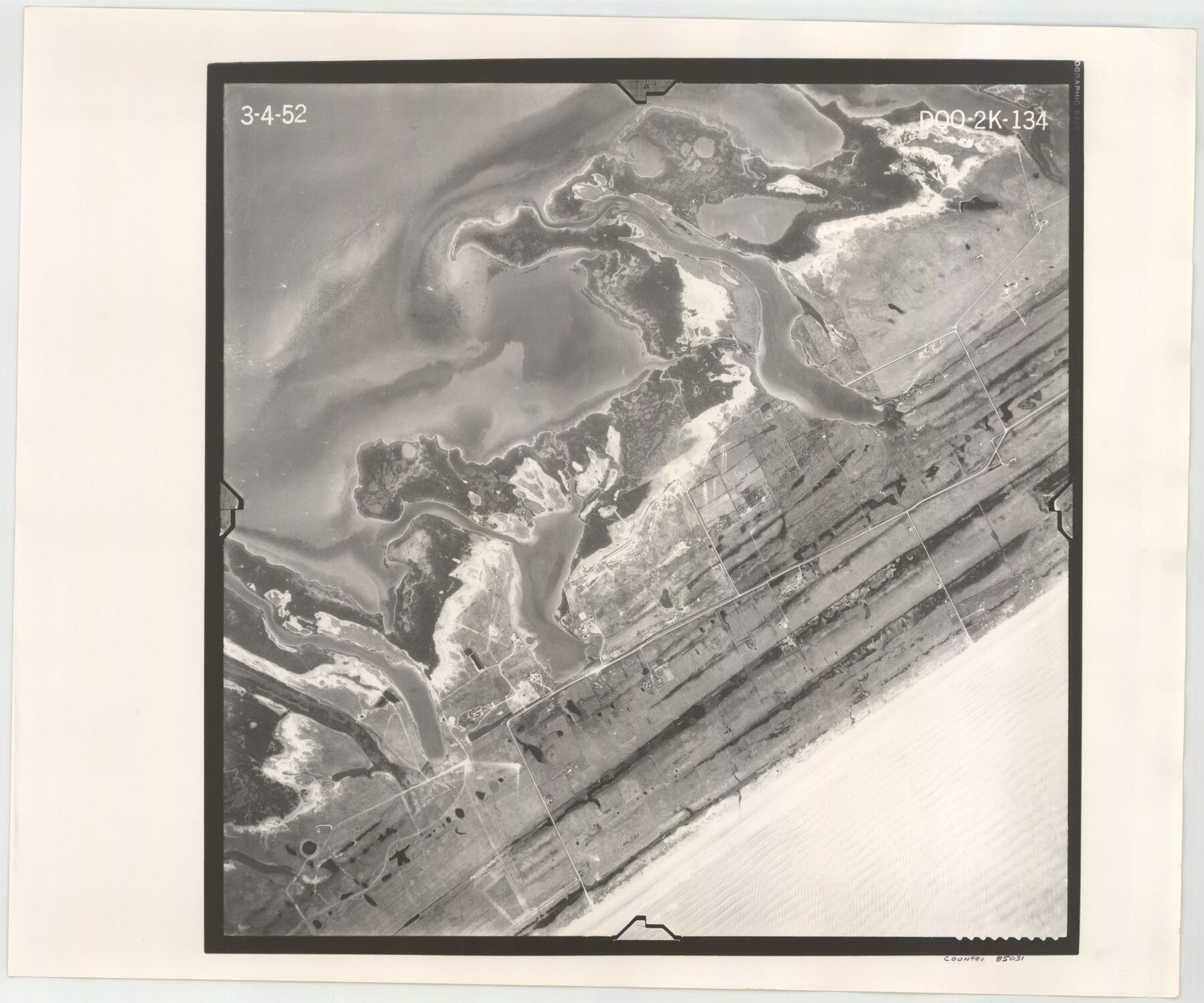
Flight Mission No. DQO-2K, Frame 134, Galveston County
DQO-2K-134
-
Map/Doc
85031
-
Collection
General Map Collection
-
Object Dates
1952/3/4 (Creation Date)
-
People and Organizations
U. S. Department of Agriculture (Publisher)
-
Counties
Galveston
-
Subjects
Aerial Photograph
-
Height x Width
18.7 x 22.4 inches
47.5 x 56.9 cm
-
Comments
Flown by Aero Exploration Company of Tulsa, Oklahoma.
Part of: General Map Collection
Kerr County Sketch File 16

Print $40.00
- Digital $50.00
Kerr County Sketch File 16
1948
Size 18.2 x 14.2 inches
Map/Doc 28888
Andrews County Working Sketch 24

Print $40.00
- Digital $50.00
Andrews County Working Sketch 24
1980
Size 55.5 x 37.4 inches
Map/Doc 67070
Hudspeth County Working Sketch 50

Print $20.00
- Digital $50.00
Hudspeth County Working Sketch 50
Size 24.6 x 37.2 inches
Map/Doc 66335
Harris County Rolled Sketch T1

Print $20.00
- Digital $50.00
Harris County Rolled Sketch T1
1916
Size 29.8 x 24.3 inches
Map/Doc 6144
Tom Green County Sketch File 88

Print $8.00
- Digital $50.00
Tom Green County Sketch File 88
1990
Size 11.5 x 8.9 inches
Map/Doc 38266
Presidio County Rolled Sketch 131A

Print $20.00
- Digital $50.00
Presidio County Rolled Sketch 131A
Size 17.7 x 11.9 inches
Map/Doc 10710
Limestone County Sketch File 3

Print $4.00
- Digital $50.00
Limestone County Sketch File 3
1850
Size 7.9 x 10.7 inches
Map/Doc 30158
Tyler County Sketch File 9a

Print $4.00
- Digital $50.00
Tyler County Sketch File 9a
1877
Size 8.1 x 7.7 inches
Map/Doc 38646
Trinity County Boundary File 102a

Print $50.00
- Digital $50.00
Trinity County Boundary File 102a
Size 9.6 x 4.7 inches
Map/Doc 59487
Hardin County Sketch File 9a

Print $4.00
- Digital $50.00
Hardin County Sketch File 9a
1860
Size 9.9 x 8.4 inches
Map/Doc 25108
Sutton County Working Sketch 47

Print $20.00
- Digital $50.00
Sutton County Working Sketch 47
1954
Size 34.3 x 21.3 inches
Map/Doc 62390
Dimmit County Working Sketch 49

Print $40.00
- Digital $50.00
Dimmit County Working Sketch 49
1980
Size 78.8 x 44.7 inches
Map/Doc 68710
You may also like
Map of Dallas County

Print $20.00
- Digital $50.00
Map of Dallas County
1861
Size 23.5 x 20.0 inches
Map/Doc 3467
The Republic County of Fannin. November 28. 1839

Print $20.00
The Republic County of Fannin. November 28. 1839
2020
Size 12.9 x 21.7 inches
Map/Doc 96129
Map of the Middle States and part of the Southern engraved to illustrate Mitchell's school and family geography

Print $20.00
- Digital $50.00
Map of the Middle States and part of the Southern engraved to illustrate Mitchell's school and family geography
1839
Size 17.8 x 11.8 inches
Map/Doc 93496
Packery Channel

Print $20.00
- Digital $50.00
Packery Channel
1958
Size 21.1 x 24.3 inches
Map/Doc 3007
Jack County Sketch File 2

Print $6.00
- Digital $50.00
Jack County Sketch File 2
1856
Size 8.8 x 8.0 inches
Map/Doc 27501
Concho County Boundary File 4

Print $2.00
- Digital $50.00
Concho County Boundary File 4
Size 12.7 x 8.4 inches
Map/Doc 51825
Points of Interest & Road Map of Scenicland, U.S.A. and United States [Verso]
![94193, Points of Interest & Road Map of Scenicland, U.S.A. and United States [Verso], General Map Collection](https://historictexasmaps.com/wmedia_w700/maps/94193-1.tif.jpg)
Points of Interest & Road Map of Scenicland, U.S.A. and United States [Verso]
1966
Size 22.5 x 35.0 inches
Map/Doc 94193
Armstrong County Sketch File B

Print $26.00
- Digital $50.00
Armstrong County Sketch File B
1903
Size 14.2 x 8.5 inches
Map/Doc 13669
Flight Mission No. DQO-1K, Frame 119, Galveston County

Print $20.00
- Digital $50.00
Flight Mission No. DQO-1K, Frame 119, Galveston County
1952
Size 19.0 x 22.6 inches
Map/Doc 84997
[Bastrop District]
![83519, [Bastrop District], General Map Collection](https://historictexasmaps.com/wmedia_w700/maps/83519-1.tif.jpg)
Print $20.00
- Digital $50.00
[Bastrop District]
1838
Size 26.5 x 44.2 inches
Map/Doc 83519
Donley County Working Sketch 11

Print $20.00
- Digital $50.00
Donley County Working Sketch 11
1904
Size 43.7 x 41.1 inches
Map/Doc 68744
Yoakum County Sketch File 7

Print $6.00
- Digital $50.00
Yoakum County Sketch File 7
1906
Size 14.5 x 9.0 inches
Map/Doc 40750