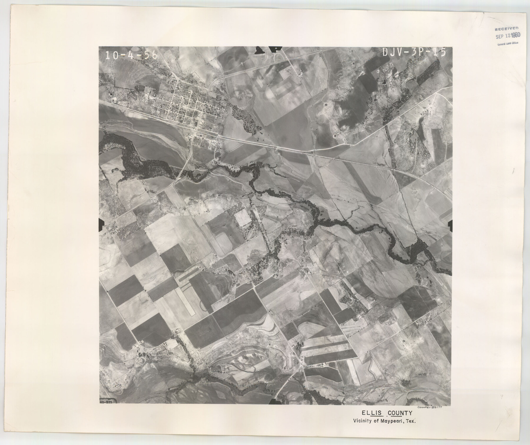
Flight Mission No. DJV-3P, Frame 15, Ellis County
DJV-3P-15
-
Map/Doc
84977
-
Collection
General Map Collection
-
Object Dates
1956/10/4 (Creation Date)
-
People and Organizations
U. S. Department of Agriculture (Publisher)
-
Counties
Ellis
-
Subjects
Aerial Photograph
-
Height x Width
18.8 x 22.4 inches
47.8 x 56.9 cm
-
Comments
Flown in the vicinity of Maypearl, Texas.
Received in office September 12, 1960.
Part of: General Map Collection
Brazoria County Sketch File 5

Print $4.00
- Digital $50.00
Brazoria County Sketch File 5
1862
Size 13.1 x 8.1 inches
Map/Doc 14929
Stephens County Sketch File 12a

Print $23.00
- Digital $50.00
Stephens County Sketch File 12a
Size 18.2 x 11.2 inches
Map/Doc 37061
Brooks County Boundary File Index

Print $2.00
- Digital $50.00
Brooks County Boundary File Index
Size 8.6 x 3.1 inches
Map/Doc 50808
Harris County Rolled Sketch 86

Print $20.00
- Digital $50.00
Harris County Rolled Sketch 86
1933
Size 33.0 x 32.2 inches
Map/Doc 73576
El Nuevo Mexico y Tierras Adyacentes Mapa Levantado para la demarcacion de los Limites de los Dominios Españoles y de los Estados Unidos

El Nuevo Mexico y Tierras Adyacentes Mapa Levantado para la demarcacion de los Limites de los Dominios Españoles y de los Estados Unidos
1811
Size 27.9 x 36.6 inches
Map/Doc 97483
Terry County Working Sketch 3

Print $40.00
- Digital $50.00
Terry County Working Sketch 3
1953
Size 125.9 x 28.4 inches
Map/Doc 62108
Shelby County Working Sketch 10

Print $20.00
- Digital $50.00
Shelby County Working Sketch 10
1945
Size 42.8 x 43.9 inches
Map/Doc 63863
Hardeman County Sketch File 16

Print $20.00
- Digital $50.00
Hardeman County Sketch File 16
Size 21.9 x 26.8 inches
Map/Doc 11628
Flight Mission No. DQO-3K, Frame 82, Galveston County

Print $20.00
- Digital $50.00
Flight Mission No. DQO-3K, Frame 82, Galveston County
1952
Size 18.7 x 22.5 inches
Map/Doc 85087
Eastland County Working Sketch 33

Print $20.00
- Digital $50.00
Eastland County Working Sketch 33
1956
Size 23.0 x 12.4 inches
Map/Doc 68814
Flight Mission No. DQO-1K, Frame 155, Galveston County

Print $20.00
- Digital $50.00
Flight Mission No. DQO-1K, Frame 155, Galveston County
1952
Size 18.9 x 22.5 inches
Map/Doc 85008
Harris County Rolled Sketch 88

Print $20.00
- Digital $50.00
Harris County Rolled Sketch 88
1935
Size 34.4 x 22.7 inches
Map/Doc 6122
You may also like
Galveston County Sketch File 57

Print $8.00
- Digital $50.00
Galveston County Sketch File 57
1910
Size 8.1 x 5.2 inches
Map/Doc 23603
[Portion of Blk. D-19 & H. & O. B. Blk. 1]
![90352, [Portion of Blk. D-19 & H. & O. B. Blk. 1], Twichell Survey Records](https://historictexasmaps.com/wmedia_w700/maps/90352-1.tif.jpg)
Print $3.00
- Digital $50.00
[Portion of Blk. D-19 & H. & O. B. Blk. 1]
Size 13.9 x 10.1 inches
Map/Doc 90352
[West Half of Potter County, South of River and West Half of Randall County]
![91828, [West Half of Potter County, South of River and West Half of Randall County], Twichell Survey Records](https://historictexasmaps.com/wmedia_w700/maps/91828.tif.jpg)
Print $20.00
- Digital $50.00
[West Half of Potter County, South of River and West Half of Randall County]
Size 25.9 x 43.0 inches
Map/Doc 91828
Wheeler County Working Sketch 10

Print $40.00
- Digital $50.00
Wheeler County Working Sketch 10
1973
Size 72.4 x 36.6 inches
Map/Doc 72499
Jefferson County Working Sketch 29

Print $40.00
- Digital $50.00
Jefferson County Working Sketch 29
1977
Size 52.4 x 42.7 inches
Map/Doc 66572
Sketch in Northwest part Crockett County

Print $20.00
- Digital $50.00
Sketch in Northwest part Crockett County
Size 14.5 x 26.3 inches
Map/Doc 90475
Matagorda County Sketch File 11

Print $6.00
- Digital $50.00
Matagorda County Sketch File 11
1885
Size 9.7 x 6.2 inches
Map/Doc 30768
[Map showing T&P Lands in El Paso County]
![88935, [Map showing T&P Lands in El Paso County], Library of Congress](https://historictexasmaps.com/wmedia_w700/maps/88935.tif.jpg)
Print $20.00
[Map showing T&P Lands in El Paso County]
Size 22.2 x 17.4 inches
Map/Doc 88935
Tyler County Working Sketch 12

Print $20.00
- Digital $50.00
Tyler County Working Sketch 12
1942
Size 21.2 x 31.7 inches
Map/Doc 69482
[Blocks 47, Z, XO2, M18, M23, M25, and H]
![91236, [Blocks 47, Z, XO2, M18, M23, M25, and H], Twichell Survey Records](https://historictexasmaps.com/wmedia_w700/maps/91236-1.tif.jpg)
Print $20.00
- Digital $50.00
[Blocks 47, Z, XO2, M18, M23, M25, and H]
Size 29.6 x 23.6 inches
Map/Doc 91236
Webb County Working Sketch 2

Print $20.00
- Digital $50.00
Webb County Working Sketch 2
1906
Size 11.2 x 12.5 inches
Map/Doc 72367
Aransas County Rolled Sketch 25

Print $20.00
- Digital $50.00
Aransas County Rolled Sketch 25
1983
Size 18.4 x 24.5 inches
Map/Doc 5061