Schleicher County Rolled Sketch 8
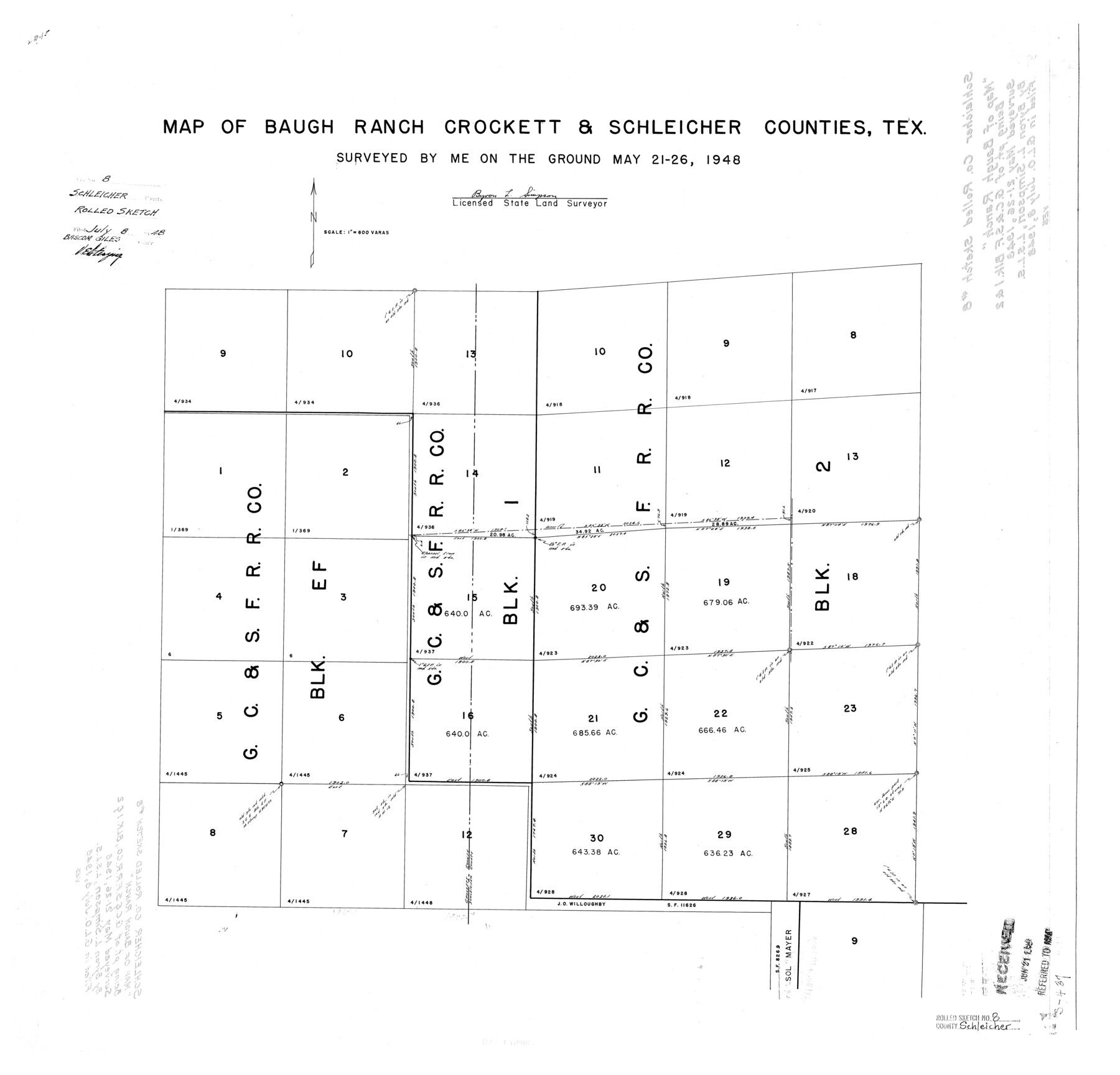
Map of Baugh Ranch, Crockett & Schleicher Counties, Tex.
-
Map/Doc
7750
-
Collection
General Map Collection
-
Object Dates
1948/5/26 (Survey Date)
1948/7/8 (File Date)
-
People and Organizations
Byron L. Simpson (Surveyor/Engineer)
-
Counties
Schleicher Crockett
-
Subjects
Surveying Rolled Sketch
-
Height x Width
27.8 x 29.0 inches
70.6 x 73.7 cm
-
Scale
1" = 600 varas
Part of: General Map Collection
Map of Stephens County

Print $20.00
- Digital $50.00
Map of Stephens County
1897
Size 42.9 x 38.2 inches
Map/Doc 63044
Maps of Gulf Intracoastal Waterway, Texas - Sabine River to the Rio Grande and connecting waterways including ship channels

Print $20.00
- Digital $50.00
Maps of Gulf Intracoastal Waterway, Texas - Sabine River to the Rio Grande and connecting waterways including ship channels
1966
Size 14.5 x 22.2 inches
Map/Doc 61940

Brooks County Sketch File 8

Print $40.00
- Digital $50.00
Brooks County Sketch File 8
1946
Size 26.5 x 38.4 inches
Map/Doc 11018
Castro County Sketch File 4k

Print $4.00
- Digital $50.00
Castro County Sketch File 4k
Size 13.6 x 8.6 inches
Map/Doc 17485

Andrews County Sketch File 8a

Print $8.00
- Digital $50.00
Andrews County Sketch File 8a
1943
Size 11.3 x 8.8 inches
Map/Doc 12849
Llano County Working Sketch 4

Print $40.00
- Digital $50.00
Llano County Working Sketch 4
1954
Size 33.4 x 54.0 inches
Map/Doc 70622
Bandera County Rolled Sketch 2

Print $20.00
- Digital $50.00
Bandera County Rolled Sketch 2
1945
Size 19.1 x 24.0 inches
Map/Doc 5114
Young County Sketch File 16

Print $4.00
- Digital $50.00
Young County Sketch File 16
1896
Size 10.3 x 8.5 inches
Map/Doc 40880
Map of Panola County

Print $20.00
- Digital $50.00
Map of Panola County
1863
Size 19.6 x 19.3 inches
Map/Doc 4503
Fractional Township No. 8 South Range No. 11 East of the Indian Meridian, Indian Territory

Print $20.00
- Digital $50.00
Fractional Township No. 8 South Range No. 11 East of the Indian Meridian, Indian Territory
1896
Size 19.3 x 24.4 inches
Map/Doc 75222
You may also like
[San Patricio No. 2]
![69746, [San Patricio No. 2], General Map Collection](https://historictexasmaps.com/wmedia_w700/maps/69746.tif.jpg)
Print $2.00
- Digital $50.00
[San Patricio No. 2]
1847
Size 8.3 x 11.2 inches
Map/Doc 69746
Crockett County Rolled Sketch 47

Print $20.00
- Digital $50.00
Crockett County Rolled Sketch 47
1939
Size 22.2 x 21.1 inches
Map/Doc 5596
Duval County Sketch File 4b

Print $4.00
- Digital $50.00
Duval County Sketch File 4b
1874
Size 10.4 x 7.8 inches
Map/Doc 21282
Port Series No. 6 - The Ports of Galveston, Houston, and Texas City, Texas

Port Series No. 6 - The Ports of Galveston, Houston, and Texas City, Texas
1924
Map/Doc 97159
Flight Mission No. DQN-5K, Frame 57, Calhoun County

Print $20.00
- Digital $50.00
Flight Mission No. DQN-5K, Frame 57, Calhoun County
1953
Size 18.9 x 22.4 inches
Map/Doc 84400
Flight Mission No. DAG-24K, Frame 47, Matagorda County

Print $20.00
- Digital $50.00
Flight Mission No. DAG-24K, Frame 47, Matagorda County
1953
Size 18.5 x 22.3 inches
Map/Doc 86534
Medina County Working Sketch 16

Print $20.00
- Digital $50.00
Medina County Working Sketch 16
1979
Size 27.1 x 28.2 inches
Map/Doc 70931
University Lands, Blocks 38 to 57, Crockett, Reagan, Irion, Schleicher Counties

Print $40.00
- Digital $50.00
University Lands, Blocks 38 to 57, Crockett, Reagan, Irion, Schleicher Counties
Size 34.0 x 53.0 inches
Map/Doc 62946
East Part of Brewster Co.

Print $40.00
- Digital $50.00
East Part of Brewster Co.
1952
Size 49.5 x 31.1 inches
Map/Doc 95436
Matagorda County Aerial Photograph Index Sheet 4

Print $20.00
- Digital $50.00
Matagorda County Aerial Photograph Index Sheet 4
1953
Size 23.6 x 19.5 inches
Map/Doc 83725
Duval County Working Sketch 1

Print $20.00
- Digital $50.00
Duval County Working Sketch 1
Size 24.6 x 36.4 inches
Map/Doc 76442
