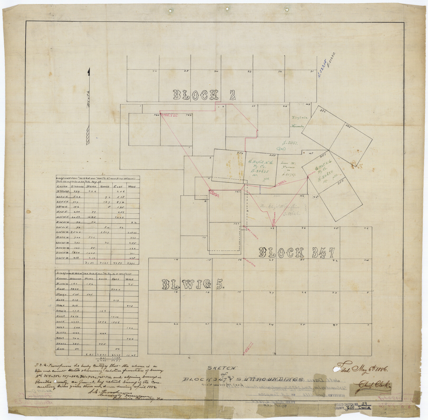
Jeff Davis County Rolled Sketch 23
Sketch of Block 347 and surroundings
Presidio County Sketch File 23
-
Map/Doc
7715
-
Collection
General Map Collection
-
Object Dates
1886 (Creation Date)
1886/5/6 (File Date)
-
People and Organizations
S.A. Thompson (Surveyor/Engineer)
-
Counties
Jeff Davis
-
Subjects
Surveying Rolled Sketch
-
Height x Width
24.9 x 25.4 inches
63.3 x 64.5 cm
-
Medium
linen, manuscript
-
Scale
1" = 1000 varas
-
Comments
See Jeff Davis County Rolled Sketch 23A (46293) and Jeff Davis County Sketch File 37 (28050) for field notes.
Related maps
Jeff Davis County Sketch File 37

Print $8.00
- Digital $50.00
Jeff Davis County Sketch File 37
1953
Size 11.3 x 8.7 inches
Map/Doc 28050
Jeff Davis County Rolled Sketch 23A

Print $11.00
- Digital $50.00
Jeff Davis County Rolled Sketch 23A
1886
Size 9.9 x 15.3 inches
Map/Doc 46293
Part of: General Map Collection
Newton County Sketch File 19

Print $20.00
- Digital $50.00
Newton County Sketch File 19
Size 22.8 x 9.4 inches
Map/Doc 42158
Palo Pinto County Sketch File 25a

Print $6.00
- Digital $50.00
Palo Pinto County Sketch File 25a
Size 11.0 x 11.4 inches
Map/Doc 33417
Taylor County Working Sketch 9

Print $20.00
- Digital $50.00
Taylor County Working Sketch 9
1955
Size 24.2 x 24.6 inches
Map/Doc 69619
Trinity River, South Dallas Sheet

Print $20.00
- Digital $50.00
Trinity River, South Dallas Sheet
1917
Size 28.8 x 21.4 inches
Map/Doc 69684
Winkler County Rolled Sketch 10

Print $40.00
- Digital $50.00
Winkler County Rolled Sketch 10
1958
Size 29.4 x 55.9 inches
Map/Doc 10151
Kinney County Working Sketch 26

Print $40.00
- Digital $50.00
Kinney County Working Sketch 26
1953
Size 37.9 x 53.6 inches
Map/Doc 70208
Dickens County Rolled Sketch C & C1

Print $35.00
- Digital $50.00
Dickens County Rolled Sketch C & C1
1895
Size 10.6 x 15.5 inches
Map/Doc 44297
Hudspeth County Sketch File 32

Print $10.00
- Digital $50.00
Hudspeth County Sketch File 32
1952
Size 11.4 x 8.9 inches
Map/Doc 26989
Flight Mission No. CUG-3P, Frame 30, Kleberg County

Print $20.00
- Digital $50.00
Flight Mission No. CUG-3P, Frame 30, Kleberg County
1956
Size 18.5 x 22.2 inches
Map/Doc 86235
Connected Map of Austin's Colony

Print $20.00
- Digital $50.00
Connected Map of Austin's Colony
1892
Size 47.5 x 43.0 inches
Map/Doc 76074
Donley County Sketch File B7

Print $20.00
- Digital $50.00
Donley County Sketch File B7
1919
Size 25.5 x 32.4 inches
Map/Doc 11377
Jim Hogg County Working Sketch Graphic Index

Print $20.00
- Digital $50.00
Jim Hogg County Working Sketch Graphic Index
1962
Size 40.0 x 28.7 inches
Map/Doc 76596
You may also like
Jefferson County Rolled Sketch 29

Print $20.00
- Digital $50.00
Jefferson County Rolled Sketch 29
1952
Size 31.8 x 43.6 inches
Map/Doc 9293
Leon County Rolled Sketch 8

Print $97.00
- Digital $50.00
Leon County Rolled Sketch 8
1955
Size 32.5 x 31.9 inches
Map/Doc 9429
General Highway Map, McMullen County, Texas

Print $20.00
General Highway Map, McMullen County, Texas
1940
Size 24.6 x 18.5 inches
Map/Doc 79193
Flight Mission No. BRA-7M, Frame 134, Jefferson County

Print $20.00
- Digital $50.00
Flight Mission No. BRA-7M, Frame 134, Jefferson County
1953
Size 18.6 x 22.5 inches
Map/Doc 85528
Atascosa County Working Sketch 2

Print $20.00
- Digital $50.00
Atascosa County Working Sketch 2
1910
Size 23.5 x 33.2 inches
Map/Doc 67197
Flight Mission No. BRA-8M, Frame 22, Jefferson County

Print $20.00
- Digital $50.00
Flight Mission No. BRA-8M, Frame 22, Jefferson County
1953
Size 18.5 x 22.4 inches
Map/Doc 85577
Kent County Rolled Sketch 5

Print $20.00
- Digital $50.00
Kent County Rolled Sketch 5
1951
Size 43.7 x 36.9 inches
Map/Doc 78522
Flight Mission No. DQO-8K, Frame 73, Galveston County

Print $20.00
- Digital $50.00
Flight Mission No. DQO-8K, Frame 73, Galveston County
1952
Size 18.6 x 22.4 inches
Map/Doc 85177
[East Half of Hockley County]
![91194, [East Half of Hockley County], Twichell Survey Records](https://historictexasmaps.com/wmedia_w700/maps/91194-1.tif.jpg)
Print $20.00
- Digital $50.00
[East Half of Hockley County]
Size 26.0 x 35.5 inches
Map/Doc 91194
Map of Escarpment Section through Webb County, Texas (North half of Webb County)

Print $40.00
- Digital $50.00
Map of Escarpment Section through Webb County, Texas (North half of Webb County)
1925
Size 43.3 x 76.3 inches
Map/Doc 93162
Zavala County Sketch File 10a

Print $6.00
- Digital $50.00
Zavala County Sketch File 10a
1885
Size 14.6 x 8.8 inches
Map/Doc 41267
Map of Williamson County

Print $20.00
- Digital $50.00
Map of Williamson County
1880
Size 20.9 x 29.0 inches
Map/Doc 4148