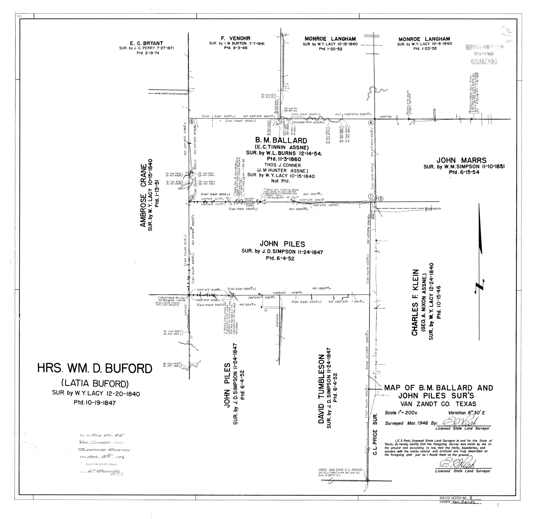
Van Zandt County Rolled Sketch 5
Map of B.M. Ballard and John Piles surs., Van Zandt Co., Texas
-
Map/Doc
8146
-
Collection
General Map Collection
-
Object Dates
3/1946 (Creation Date)
4/8/1946 (File Date)
-
People and Organizations
E.S. Rest (Surveyor/Engineer)
-
Counties
Van Zandt
-
Subjects
Surveying Rolled Sketch
-
Height x Width
27.1 x 28.1 inches
68.8 x 71.4 cm
-
Scale
1" = 200 varas
Part of: General Map Collection
[Sketch for Mineral Application 35981 - Liberty County, John Mecom]
![65617, [Sketch for Mineral Application 35981 - Liberty County, John Mecom], General Map Collection](https://historictexasmaps.com/wmedia_w700/maps/65617.tif.jpg)
Print $20.00
- Digital $50.00
[Sketch for Mineral Application 35981 - Liberty County, John Mecom]
1941
Size 30.2 x 26.5 inches
Map/Doc 65617
Sterling County Sketch File 24

Print $6.00
- Digital $50.00
Sterling County Sketch File 24
1955
Size 11.1 x 8.5 inches
Map/Doc 37189
Sherman County Boundary File 4

Print $54.00
- Digital $50.00
Sherman County Boundary File 4
Size 8.9 x 8.5 inches
Map/Doc 58782
Chambers County Sketch File 24

Print $20.00
- Digital $50.00
Chambers County Sketch File 24
1909
Size 34.1 x 14.5 inches
Map/Doc 11065
Hamilton County Sketch File 5

Print $4.00
- Digital $50.00
Hamilton County Sketch File 5
Size 10.2 x 8.1 inches
Map/Doc 24908
Presidio County Working Sketch 72

Print $20.00
- Digital $50.00
Presidio County Working Sketch 72
1962
Size 22.1 x 21.1 inches
Map/Doc 71749
Brown County Working Sketch 5

Print $20.00
- Digital $50.00
Brown County Working Sketch 5
1939
Size 20.9 x 24.0 inches
Map/Doc 67770
Limestone County Working Sketch 17

Print $20.00
- Digital $50.00
Limestone County Working Sketch 17
1959
Size 42.2 x 33.1 inches
Map/Doc 70567
Zapata County

Print $40.00
- Digital $50.00
Zapata County
1901
Size 53.1 x 38.0 inches
Map/Doc 63143
San Jacinto County Rolled Sketch 3

Print $40.00
- Digital $50.00
San Jacinto County Rolled Sketch 3
Size 24.4 x 59.4 inches
Map/Doc 9880

[Galveston, Harrisburg & San Antonio through El Paso County]
![64010, [Galveston, Harrisburg & San Antonio through El Paso County], General Map Collection](https://historictexasmaps.com/wmedia_w700/maps/64010.tif.jpg)
Print $20.00
- Digital $50.00
[Galveston, Harrisburg & San Antonio through El Paso County]
1906
Size 13.4 x 33.9 inches
Map/Doc 64010
You may also like
Duval County Boundary File 1

Print $26.00
- Digital $50.00
Duval County Boundary File 1
Size 8.4 x 3.7 inches
Map/Doc 52657
Rusk County Sketch File Z

Print $6.00
Rusk County Sketch File Z
1850
Size 15.8 x 9.0 inches
Map/Doc 35539
Trinity County Working Sketch 18

Print $20.00
- Digital $50.00
Trinity County Working Sketch 18
1982
Size 13.4 x 11.1 inches
Map/Doc 69467
The Mexican Municipality of Harrisburg. Defined, January 4, 1836

Print $20.00
The Mexican Municipality of Harrisburg. Defined, January 4, 1836
2020
Size 18.4 x 21.7 inches
Map/Doc 96022
General Highway Map, Polk County, Texas

Print $20.00
General Highway Map, Polk County, Texas
1961
Size 18.1 x 24.5 inches
Map/Doc 79630
[Northeast Portion of Hartley County]
![91118, [Northeast Portion of Hartley County], Twichell Survey Records](https://historictexasmaps.com/wmedia_w700/maps/91118-1.tif.jpg)
Print $2.00
- Digital $50.00
[Northeast Portion of Hartley County]
Size 13.9 x 8.5 inches
Map/Doc 91118
Hamilton County Boundary File 4

Print $60.00
- Digital $50.00
Hamilton County Boundary File 4
Size 9.2 x 8.1 inches
Map/Doc 54205
Calhoun County NRC Article 33.136 Sketch 15

Print $46.00
Calhoun County NRC Article 33.136 Sketch 15
2025
Map/Doc 97428
Marion County Working Sketch 14

Print $20.00
- Digital $50.00
Marion County Working Sketch 14
1956
Size 25.1 x 25.0 inches
Map/Doc 70790

Flight Mission No. DAG-14K, Frame 142, Matagorda County

Print $20.00
- Digital $50.00
Flight Mission No. DAG-14K, Frame 142, Matagorda County
1952
Size 16.5 x 16.4 inches
Map/Doc 86309
United States Atlantic and Gulf Coasts Including Puerto Rico and the Virgin Islands

Print $40.00
- Digital $50.00
United States Atlantic and Gulf Coasts Including Puerto Rico and the Virgin Islands
1989
Size 20.6 x 60.3 inches
Map/Doc 73553