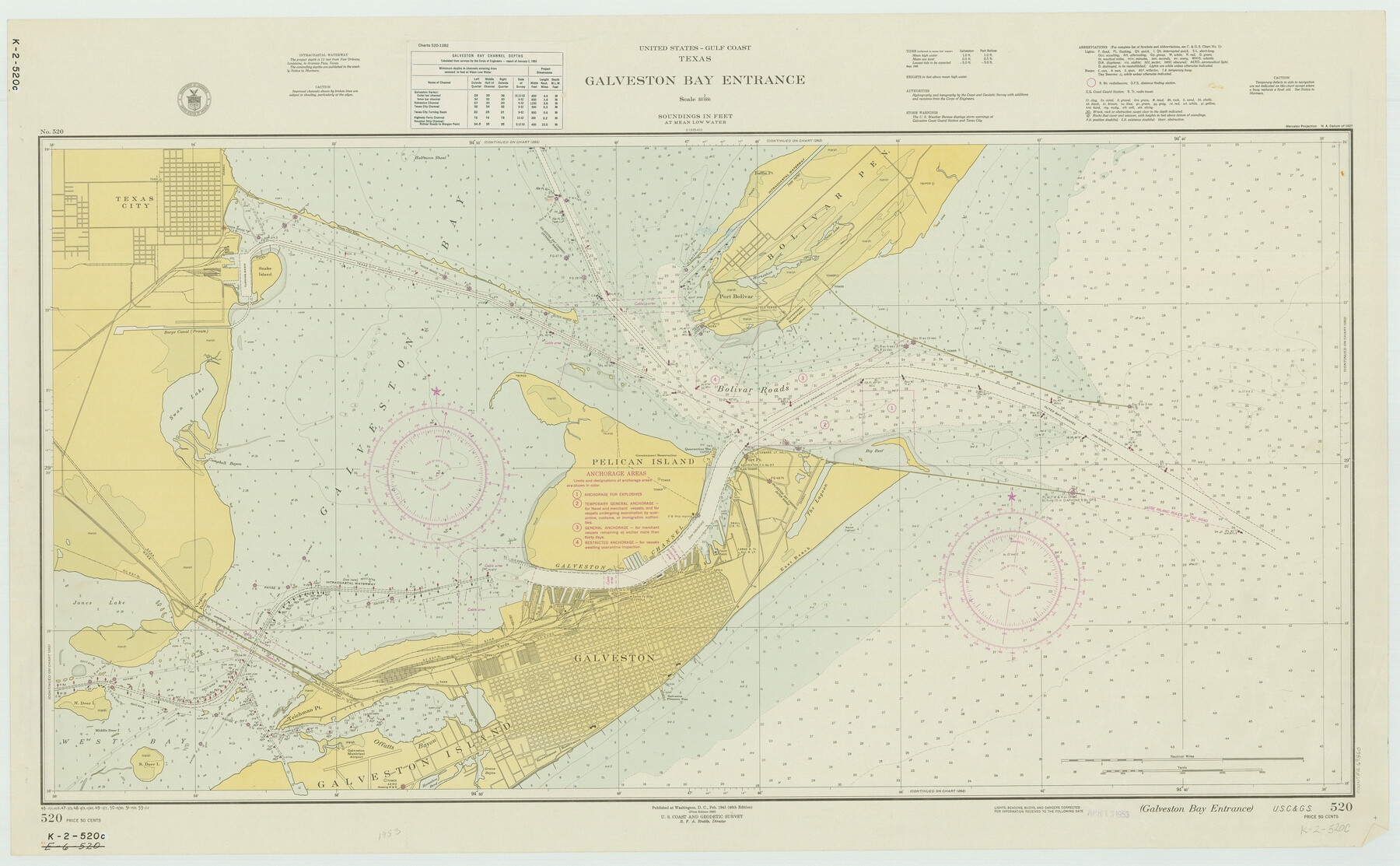
Galveston Bay Entrance
K-2-520c
-
Map/Doc
69860
-
Collection
General Map Collection
-
Object Dates
1953 (Creation Date)
-
Counties
Galveston
-
Subjects
Nautical Charts
-
Height x Width
26.1 x 42.2 inches
66.3 x 107.2 cm
Part of: General Map Collection
Kleberg County Rolled Sketch 10-41

Print $20.00
- Digital $50.00
Kleberg County Rolled Sketch 10-41
1952
Size 41.2 x 32.7 inches
Map/Doc 9385
King County Working Sketch 1

Print $20.00
- Digital $50.00
King County Working Sketch 1
1913
Size 18.2 x 23.8 inches
Map/Doc 70165
Lamar County Rolled Sketch 1

Print $40.00
- Digital $50.00
Lamar County Rolled Sketch 1
1989
Size 50.3 x 39.1 inches
Map/Doc 9553
Flight Mission No. CRE-1R, Frame 125, Jackson County

Print $20.00
- Digital $50.00
Flight Mission No. CRE-1R, Frame 125, Jackson County
1956
Size 17.5 x 22.3 inches
Map/Doc 85336
Sketch of Sabine Lake and Pass

Print $20.00
- Digital $50.00
Sketch of Sabine Lake and Pass
1840
Size 24.8 x 18.2 inches
Map/Doc 72725
Brewster County Rolled Sketch 61

Print $40.00
- Digital $50.00
Brewster County Rolled Sketch 61
1939
Size 43.7 x 70.3 inches
Map/Doc 8486
Milam County Sketch File 4

Print $4.00
- Digital $50.00
Milam County Sketch File 4
Size 7.6 x 8.2 inches
Map/Doc 31630
East Part of Brewster Co.

Print $40.00
- Digital $50.00
East Part of Brewster Co.
1952
Size 48.5 x 30.7 inches
Map/Doc 73087
Webb County Working Sketch 45

Print $20.00
- Digital $50.00
Webb County Working Sketch 45
1944
Size 28.1 x 28.9 inches
Map/Doc 72410
Live Oak County Boundary File 60d

Print $4.00
- Digital $50.00
Live Oak County Boundary File 60d
Size 14.2 x 8.8 inches
Map/Doc 56423
Dickens County Sketch File O

Print $8.00
- Digital $50.00
Dickens County Sketch File O
1903
Size 13.3 x 8.7 inches
Map/Doc 20944
Travis County Sketch File 71

Print $10.00
- Digital $50.00
Travis County Sketch File 71
1840
Size 12.9 x 8.3 inches
Map/Doc 38456
You may also like
Henderson County Sketch File 3

Print $4.00
- Digital $50.00
Henderson County Sketch File 3
1852
Size 10.3 x 8.4 inches
Map/Doc 26321
Wood County Working Sketch 14

Print $20.00
- Digital $50.00
Wood County Working Sketch 14
1968
Size 30.1 x 31.6 inches
Map/Doc 62014

Bee County Sketch File 25

Print $4.00
- Digital $50.00
Bee County Sketch File 25
1880
Size 11.0 x 8.2 inches
Map/Doc 14326
Jefferson County Sketch File 20

Print $40.00
- Digital $50.00
Jefferson County Sketch File 20
1872
Size 12.3 x 15.0 inches
Map/Doc 28169
Dickens County Sketch File 2a

Print $4.00
- Digital $50.00
Dickens County Sketch File 2a
1884
Size 14.2 x 8.9 inches
Map/Doc 20950
Nueces County Rolled Sketch 69

Print $20.00
- Digital $50.00
Nueces County Rolled Sketch 69
Size 23.8 x 33.0 inches
Map/Doc 6920
Brewster County Sketch File N-2

Print $44.00
- Digital $50.00
Brewster County Sketch File N-2
1881
Size 8.2 x 12.8 inches
Map/Doc 15567
Map of Liberty County

Print $40.00
- Digital $50.00
Map of Liberty County
1903
Size 54.9 x 53.6 inches
Map/Doc 16878
Austin County Sketch File 11

Print $8.00
- Digital $50.00
Austin County Sketch File 11
1895
Size 11.1 x 8.6 inches
Map/Doc 13877
Translations of Titles - Austin's Second Contract, Vol. 2

Translations of Titles - Austin's Second Contract, Vol. 2
1841
Map/Doc 94547
