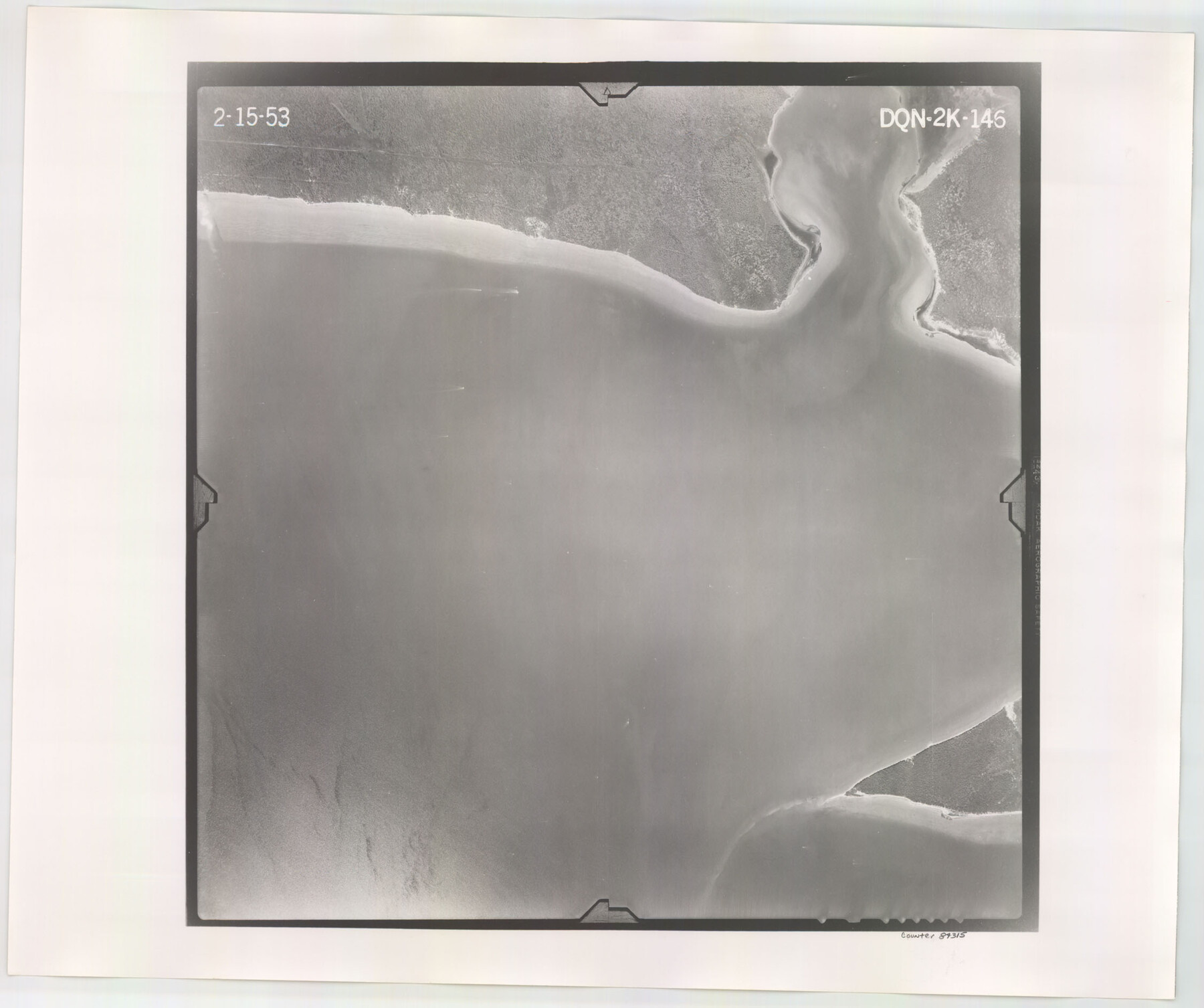
Flight Mission No. DQN-2K, Frame 146, Calhoun County
DQN-2K-146
-
Map/Doc
84315
-
Collection
General Map Collection
-
Object Dates
1953/2/15 (Creation Date)
-
People and Organizations
U. S. Department of Agriculture (Publisher)
-
Counties
Calhoun
-
Subjects
Aerial Photograph
-
Height x Width
18.9 x 22.5 inches
48.0 x 57.2 cm
-
Comments
Flown by Aero Exploration Company of Tulsa, Oklahoma.
Part of: General Map Collection
Waller County Sketch File 3

Print $4.00
- Digital $50.00
Waller County Sketch File 3
Size 13.0 x 8.4 inches
Map/Doc 39598
A Map of Dallas County

Print $20.00
- Digital $50.00
A Map of Dallas County
1854
Size 20.9 x 16.6 inches
Map/Doc 4526
Dimmit County Sketch File 47

Print $24.00
- Digital $50.00
Dimmit County Sketch File 47
1908
Size 11.2 x 9.0 inches
Map/Doc 21178
Jeff Davis County Working Sketch 18

Print $20.00
- Digital $50.00
Jeff Davis County Working Sketch 18
1956
Size 31.3 x 21.5 inches
Map/Doc 66513

Flight Mission No. CLL-1N, Frame 31, Willacy County

Print $20.00
- Digital $50.00
Flight Mission No. CLL-1N, Frame 31, Willacy County
1954
Size 18.5 x 22.2 inches
Map/Doc 87012
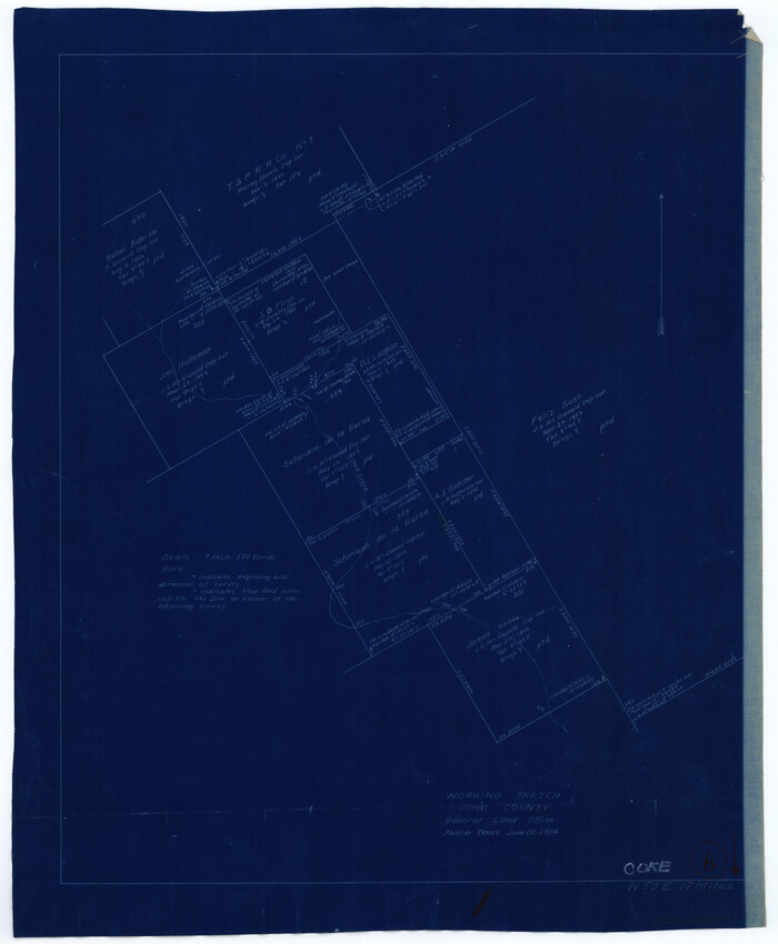
Coke County Working Sketch 6
Print $20.00
- Digital $50.00
Coke County Working Sketch 6
1914
Size 19.1 x 15.7 inches
Map/Doc 68043
Comanche County Sketch File 7

Print $6.00
- Digital $50.00
Comanche County Sketch File 7
1852
Size 9.9 x 8.1 inches
Map/Doc 19063
Wharton County Rolled Sketch 13

Print $20.00
- Digital $50.00
Wharton County Rolled Sketch 13
1990
Size 22.4 x 28.1 inches
Map/Doc 8238
Hudspeth County Working Sketch 12

Print $20.00
- Digital $50.00
Hudspeth County Working Sketch 12
1948
Size 18.2 x 38.6 inches
Map/Doc 66294
Pecos County Working Sketch 134

Print $40.00
- Digital $50.00
Pecos County Working Sketch 134
1979
Size 53.3 x 37.3 inches
Map/Doc 71608
Tyler County Working Sketch 24

Print $20.00
- Digital $50.00
Tyler County Working Sketch 24
1989
Size 34.8 x 40.6 inches
Map/Doc 69494
You may also like
[Channing Vacancy, Leagues 217- 235 and Vicinity]
![91483, [Channing Vacancy, Leagues 217- 235 and Vicinity], Twichell Survey Records](https://historictexasmaps.com/wmedia_w700/maps/91483-1.tif.jpg)
Print $20.00
- Digital $50.00
[Channing Vacancy, Leagues 217- 235 and Vicinity]
Size 26.7 x 27.6 inches
Map/Doc 91483
Terrell County

Print $20.00
- Digital $50.00
Terrell County
1905
Size 40.5 x 32.3 inches
Map/Doc 4075
Taylor County Working Sketch 4a

Print $20.00
- Digital $50.00
Taylor County Working Sketch 4a
1944
Size 17.2 x 14.0 inches
Map/Doc 69613
Lubbock County Rolled Sketch 5

Print $20.00
- Digital $50.00
Lubbock County Rolled Sketch 5
Size 19.8 x 14.2 inches
Map/Doc 6641
Jefferson County Working Sketch 8

Print $20.00
- Digital $50.00
Jefferson County Working Sketch 8
1931
Size 34.9 x 18.2 inches
Map/Doc 66551
Tarrant County Working Sketch 17

Print $20.00
- Digital $50.00
Tarrant County Working Sketch 17
1983
Size 24.6 x 20.7 inches
Map/Doc 62434
Webb County Working Sketch 35

Print $40.00
- Digital $50.00
Webb County Working Sketch 35
1939
Size 54.5 x 36.2 inches
Map/Doc 72400
Young County Sketch File 12

Print $4.00
- Digital $50.00
Young County Sketch File 12
1889
Size 8.5 x 13.6 inches
Map/Doc 40876
Comal County Working Sketch 4

Print $20.00
- Digital $50.00
Comal County Working Sketch 4
1950
Size 38.3 x 24.3 inches
Map/Doc 68170
Pecos County Rolled Sketch 129

Print $40.00
- Digital $50.00
Pecos County Rolled Sketch 129
Size 52.8 x 45.3 inches
Map/Doc 9727
Flight Mission No. DQN-5K, Frame 26, Calhoun County

Print $20.00
- Digital $50.00
Flight Mission No. DQN-5K, Frame 26, Calhoun County
1953
Size 18.6 x 22.3 inches
Map/Doc 84377
Plan of the City of Austin

Print $40.00
- Digital $50.00
Plan of the City of Austin
1840
Size 54.0 x 38.9 inches
Map/Doc 2176