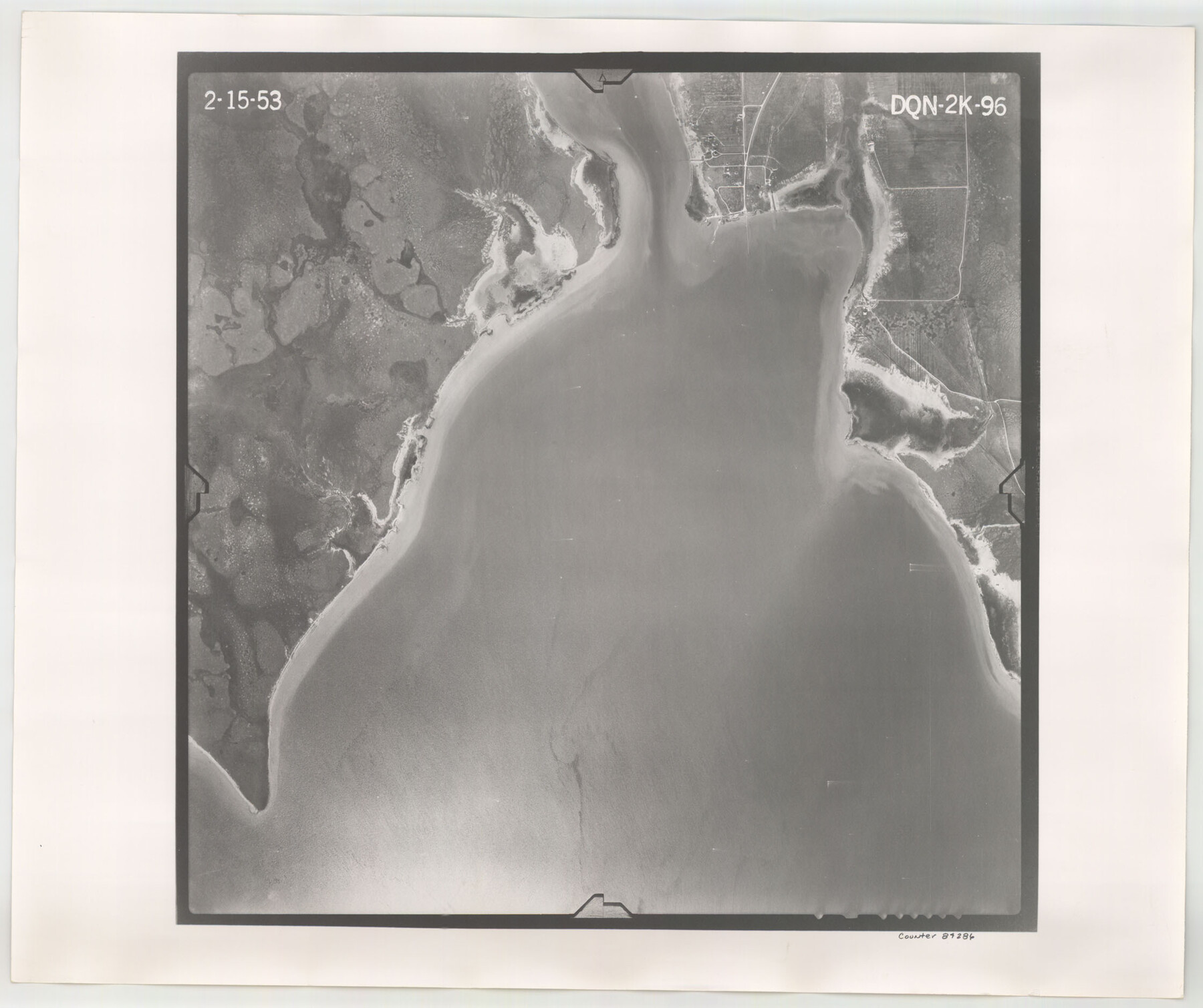
Flight Mission No. DQN-2K, Frame 96, Calhoun County
DQN-2K-96
-
Map/Doc
84286
-
Collection
General Map Collection
-
Object Dates
1953/2/15 (Creation Date)
-
People and Organizations
U. S. Department of Agriculture (Publisher)
-
Counties
Calhoun
-
Subjects
Aerial Photograph
-
Height x Width
18.8 x 22.4 inches
47.8 x 56.9 cm
-
Comments
Flown by Aero Exploration Company of Tulsa, Oklahoma.
Part of: General Map Collection
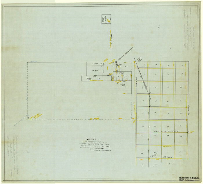
Gonzales County Working Sketch 10

Print $20.00
- Digital $50.00
Gonzales County Working Sketch 10
1981
Size 18.9 x 14.7 inches
Map/Doc 63226
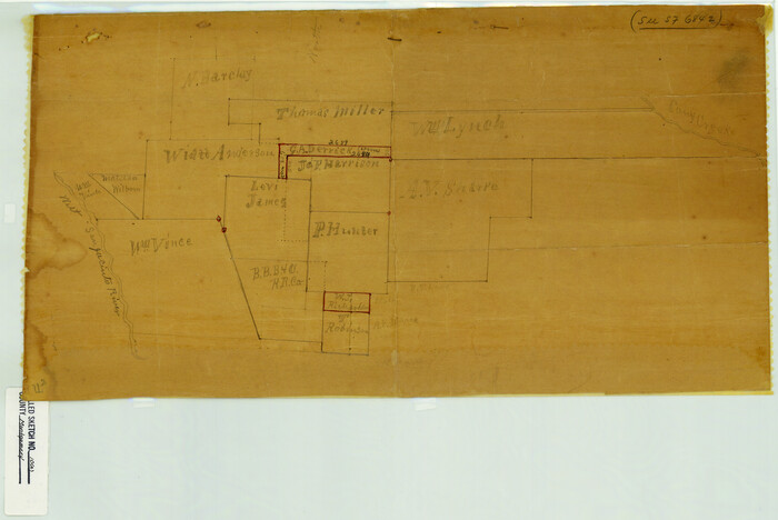
Schleicher County Sketch File 22

Print $9.00
- Digital $50.00
Schleicher County Sketch File 22
1927
Size 12.8 x 11.7 inches
Map/Doc 36512
Gregg County Sketch File 3

Print $6.00
- Digital $50.00
Gregg County Sketch File 3
1931
Size 11.2 x 8.7 inches
Map/Doc 24569
Frio County Rolled Sketch 27

Print $20.00
- Digital $50.00
Frio County Rolled Sketch 27
2013
Size 36.0 x 24.6 inches
Map/Doc 93417
Collingsworth County Working Sketch 2

Print $40.00
- Digital $50.00
Collingsworth County Working Sketch 2
1957
Size 44.2 x 122.7 inches
Map/Doc 68090
Henderson County Rolled Sketch 11

Print $20.00
- Digital $50.00
Henderson County Rolled Sketch 11
1915
Size 29.4 x 42.4 inches
Map/Doc 75957
Galveston County

Print $40.00
- Digital $50.00
Galveston County
1939
Size 44.0 x 55.5 inches
Map/Doc 73155
Wilbarger County Sketch File 2

Print $4.00
- Digital $50.00
Wilbarger County Sketch File 2
1862
Size 8.9 x 7.9 inches
Map/Doc 40164
Montgomery County Rolled Sketch 10A
Print $20.00
- Digital $50.00
Montgomery County Rolled Sketch 10A
Size 12.1 x 18.1 inches
Map/Doc 6800
Cherokee County Working Sketch 21

Print $40.00
- Digital $50.00
Cherokee County Working Sketch 21
1969
Size 37.6 x 57.0 inches
Map/Doc 67976
Galveston County Rolled Sketch 9

Print $20.00
- Digital $50.00
Galveston County Rolled Sketch 9
1905
Size 45.2 x 37.2 inches
Map/Doc 9090
Bandera County Boundary File 4b

Print $16.00
- Digital $50.00
Bandera County Boundary File 4b
Size 13.0 x 8.1 inches
Map/Doc 50281
You may also like
Menard County Working Sketch 16

Print $40.00
- Digital $50.00
Menard County Working Sketch 16
1946
Size 49.1 x 39.1 inches
Map/Doc 70963
[Yates survey 34 1/2 and vicinity]
![91690, [Yates survey 34 1/2 and vicinity], Twichell Survey Records](https://historictexasmaps.com/wmedia_w700/maps/91690-1.tif.jpg)
Print $20.00
- Digital $50.00
[Yates survey 34 1/2 and vicinity]
Size 12.6 x 17.7 inches
Map/Doc 91690
Upton County Rolled Sketch 35

Print $20.00
- Digital $50.00
Upton County Rolled Sketch 35
1951
Size 37.3 x 19.2 inches
Map/Doc 8077
Flight Mission No. DAH-9M, Frame 164, Orange County

Print $20.00
- Digital $50.00
Flight Mission No. DAH-9M, Frame 164, Orange County
1953
Size 18.6 x 22.3 inches
Map/Doc 86863
Ward County Working Sketch 32

Print $40.00
- Digital $50.00
Ward County Working Sketch 32
1967
Size 32.5 x 66.0 inches
Map/Doc 72338
Culberson County Rolled Sketch 38A
Print $20.00
- Digital $50.00
Culberson County Rolled Sketch 38A
Size 27.2 x 30.0 inches
Map/Doc 5662
Flight Mission No. CRK-8P, Frame 117, Refugio County

Print $20.00
- Digital $50.00
Flight Mission No. CRK-8P, Frame 117, Refugio County
1956
Size 18.1 x 22.0 inches
Map/Doc 86972
Map of Padre Island Showing Location of Zoning Districts

Print $20.00
- Digital $50.00
Map of Padre Island Showing Location of Zoning Districts
1971
Size 18.7 x 26.6 inches
Map/Doc 4808
[Drawings of individual counties for Pressler and Langermann's 1879 Map of Texas]
![[Drawings of individual counties for Pressler and Langermann's 1879 Map of Texas]](https://historictexasmaps.com/wmedia_w700/maps/4863.tif.jpg)
Print $20.00
- Digital $50.00
[Drawings of individual counties for Pressler and Langermann's 1879 Map of Texas]
1878
Size 38.8 x 26.8 inches
Map/Doc 4863
Burnet County Sketch File 7

Print $6.00
- Digital $50.00
Burnet County Sketch File 7
1854
Size 7.1 x 8.1 inches
Map/Doc 16686
Brewster County Working Sketch 116

Print $20.00
- Digital $50.00
Brewster County Working Sketch 116
1979
Size 25.3 x 38.6 inches
Map/Doc 67716
Webb County Working Sketch 43

Print $20.00
- Digital $50.00
Webb County Working Sketch 43
1942
Size 18.4 x 27.5 inches
Map/Doc 72408