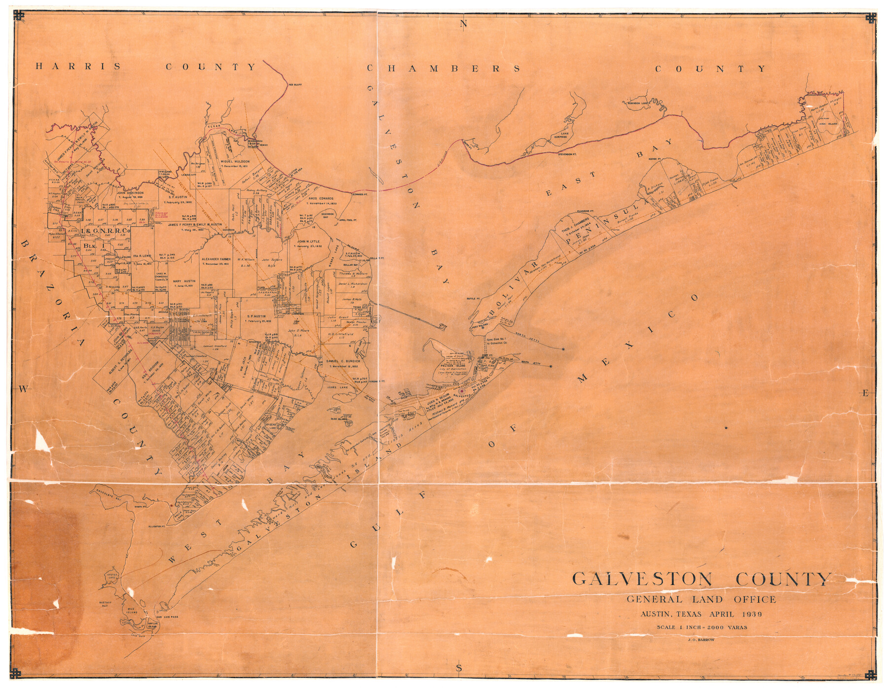
Galveston County
-
Map/Doc
73155
-
Collection
General Map Collection
-
Object Dates
1939 (Creation Date)
-
People and Organizations
Texas General Land Office (Publisher)
J.O. Barrow (Draftsman)
-
Counties
Galveston
-
Subjects
County
-
Height x Width
44.0 x 55.5 inches
111.8 x 141.0 cm
-
Comments
Hand lettered.
-
Features
Highland Bayou
Basford Bayou
South Jetty
North Jetty
Fort Point
Pelican Island
Galveston
Sydnors Bayou
Offatts Bayou
Lake Sweetwater
Deer Islands
Greens Lake
Jones Lake
Virginia Point
Dollar Bay
Snake Island
Swan Lake
Texas City
Horse Shoe Lake
Baffle Point
Moses Bayou
Gum Bayou
Alligator Point
Hitchcock
LaMarque
Alta Loma
League City
Red Bluff
Port Bolivar
San Luis Island
Titlum-Tatlum Island
Mud Island
Bastrop Bay
Moses Lake
Oyster Lake
Nymph Point
Halls Lake
Galveston Island State Park
Lake Como
Eckert's Bayou
Karankawa Lake
Chocolate Bay
Willow Bayou
Robinson Lake
Galveston Bay
Flake
Patton
Gilcrist
High Island
High Island
Mud Bayou
East Bay Bayou
Pasture Bayou
Marsh Point
East Bay
Elmgrove Point
Stevenson Point
Smith Point
Lake Surprise
MPRR
GC&SF
Texas City Terminal
Gold Pass
San Luis Pass
Dickinson Bayou
Dollar Point
April Fool Point
Edwards Point
Dickinson Bay
Dickinson
Kemah
Clifton by the Sea
Galveston Houston Electric
SPRR
GH&H
The Lagoon
Mary's Creek
Coward's Creek
Chigoe Bayour
Clear Creek
Clear Lake
Bolivar Peninsula
Galveston Island
Gulf of Mexico
West Bay
Part of: General Map Collection
Shelby County Sketch File 6

Print $8.00
- Digital $50.00
Shelby County Sketch File 6
1854
Size 12.4 x 8.2 inches
Map/Doc 36601
Olney's School Atlas

Print $326.00
- Digital $50.00
Olney's School Atlas
1844
Size 12.3 x 10.0 inches
Map/Doc 93534
Map of Montague County

Print $20.00
- Digital $50.00
Map of Montague County
1868
Size 19.9 x 16.9 inches
Map/Doc 3888
Johnson County Sketch File 3

Print $4.00
- Digital $50.00
Johnson County Sketch File 3
Size 10.1 x 8.0 inches
Map/Doc 28433
Hutchinson County Working Sketch 20

Print $20.00
- Digital $50.00
Hutchinson County Working Sketch 20
1960
Size 27.5 x 23.1 inches
Map/Doc 66380
Matagorda County Working Sketch 18

Print $20.00
- Digital $50.00
Matagorda County Working Sketch 18
1961
Size 31.2 x 41.8 inches
Map/Doc 70876
Irion County Rolled Sketch 24

Print $40.00
- Digital $50.00
Irion County Rolled Sketch 24
Size 49.4 x 37.4 inches
Map/Doc 9257

Harrison County Sketch File 21

Print $20.00
- Digital $50.00
Harrison County Sketch File 21
1892
Size 20.2 x 25.7 inches
Map/Doc 11694
Reagan County Sketch File 28

Print $20.00
- Digital $50.00
Reagan County Sketch File 28
1951
Size 29.6 x 21.7 inches
Map/Doc 12224
Rockwall County Sketch File 4

Print $9.00
Rockwall County Sketch File 4
1860
Size 7.7 x 12.1 inches
Map/Doc 35419
Aransas County Rolled Sketch 2

Print $40.00
- Digital $50.00
Aransas County Rolled Sketch 2
1950
Size 42.5 x 48.6 inches
Map/Doc 73611
You may also like
'The Cradle of Texas' - San Augustine

Print $20.00
- Digital $50.00
'The Cradle of Texas' - San Augustine
Size 19.3 x 25.3 inches
Map/Doc 94441

Zavala County Working Sketch 11

Print $20.00
- Digital $50.00
Zavala County Working Sketch 11
1955
Size 13.8 x 22.4 inches
Map/Doc 62086
Montague County Working Sketch 5

Print $20.00
- Digital $50.00
Montague County Working Sketch 5
1920
Size 24.9 x 20.9 inches
Map/Doc 71071
Harris County Working Sketch 23

Print $20.00
- Digital $50.00
Harris County Working Sketch 23
1926
Size 14.0 x 20.0 inches
Map/Doc 65915
Wise County Sketch File 2

Print $8.00
- Digital $50.00
Wise County Sketch File 2
1856
Size 8.2 x 13.4 inches
Map/Doc 40523
Tom Green County Rolled Sketch 5

Print $20.00
- Digital $50.00
Tom Green County Rolled Sketch 5
1947
Size 44.9 x 35.0 inches
Map/Doc 9997
Jeff Davis County Working Sketch 16

Print $20.00
- Digital $50.00
Jeff Davis County Working Sketch 16
1954
Size 19.4 x 17.3 inches
Map/Doc 66511
Liberty County Working Sketch 90

Print $20.00
- Digital $50.00
Liberty County Working Sketch 90
2001
Size 23.1 x 43.1 inches
Map/Doc 70550
Flight Mission No. CGI-1N, Frame 143, Cameron County

Print $20.00
- Digital $50.00
Flight Mission No. CGI-1N, Frame 143, Cameron County
1955
Size 18.6 x 22.1 inches
Map/Doc 84499
Map of Callahan County

Print $20.00
- Digital $50.00
Map of Callahan County
1878
Size 23.0 x 18.8 inches
Map/Doc 3361
Bee County Sketch File 25

Print $4.00
- Digital $50.00
Bee County Sketch File 25
1880
Size 11.0 x 8.2 inches
Map/Doc 14326