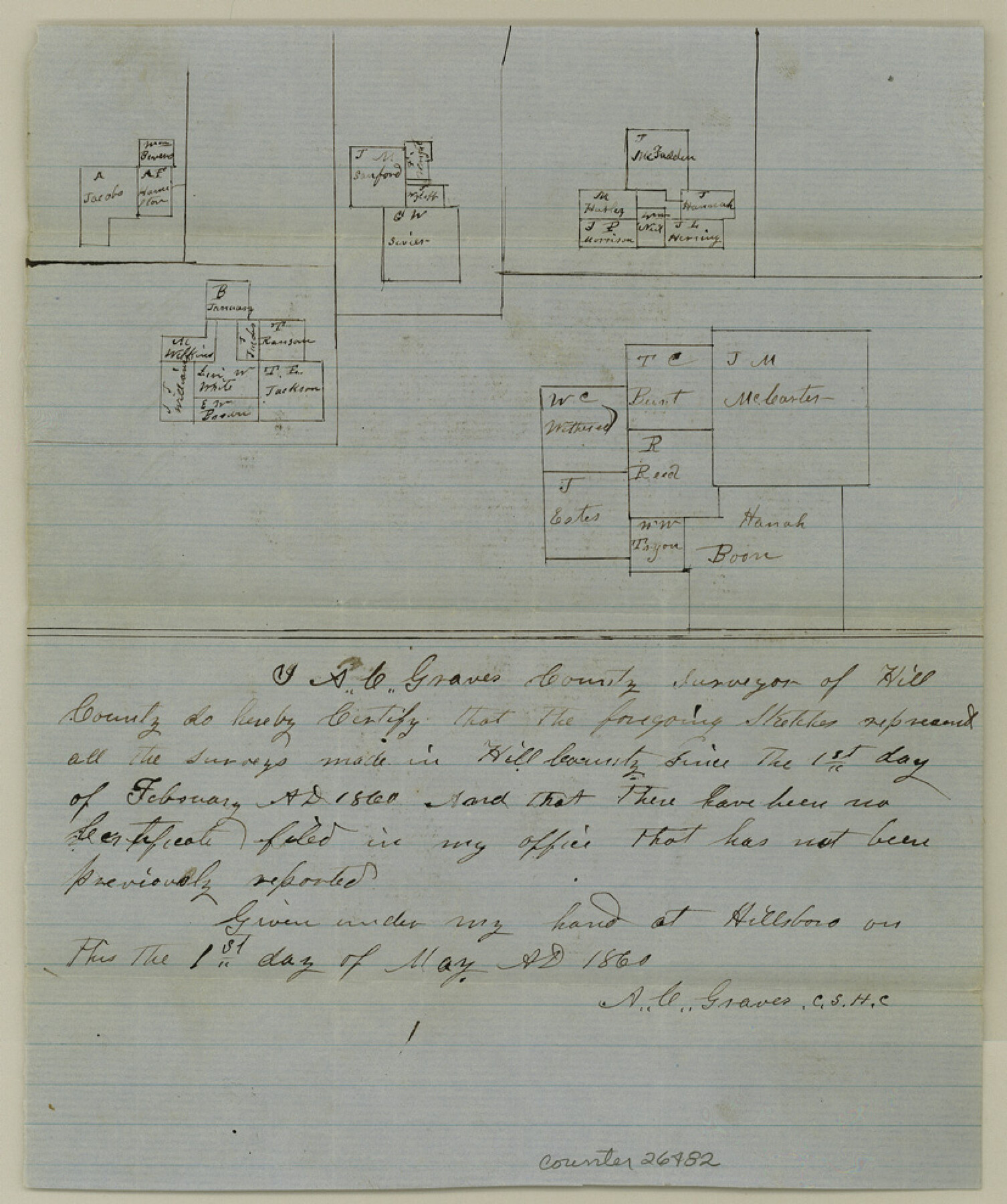
Hill County Sketch File 16
[Multiple sketches]
-
Map/Doc
26482
-
Collection
General Map Collection
-
Object Dates
5/1/1860 (Creation Date)
5/9/1860 (File Date)
2/1/1860 (Survey Date)
-
People and Organizations
A.C. Graves (Surveyor/Engineer)
-
Counties
Hill
-
Subjects
Surveying Sketch File
-
Height x Width
9.9 x 8.3 inches
25.1 x 21.1 cm
-
Medium
paper, manuscript
Part of: General Map Collection
Kent County Working Sketch 12

Print $20.00
- Digital $50.00
Kent County Working Sketch 12
1953
Size 33.8 x 24.3 inches
Map/Doc 70019
Kimble County Working Sketch 32

Print $20.00
- Digital $50.00
Kimble County Working Sketch 32
1944
Size 22.6 x 16.0 inches
Map/Doc 70100
Jeff Davis County Rolled Sketch 33

Print $20.00
- Digital $50.00
Jeff Davis County Rolled Sketch 33
1986
Size 39.8 x 30.6 inches
Map/Doc 6379
Brazoria County Rolled Sketch 36

Print $20.00
- Digital $50.00
Brazoria County Rolled Sketch 36
Size 18.5 x 25.0 inches
Map/Doc 5172
Colorado River, Hungerford Sheet

Print $6.00
- Digital $50.00
Colorado River, Hungerford Sheet
1941
Size 24.1 x 35.4 inches
Map/Doc 65309
[Texas & Pacific Railway through Callahan County]
![64232, [Texas & Pacific Railway through Callahan County], General Map Collection](https://historictexasmaps.com/wmedia_w700/maps/64232.tif.jpg)
Print $20.00
- Digital $50.00
[Texas & Pacific Railway through Callahan County]
1918
Size 20.8 x 9.4 inches
Map/Doc 64232
Kleberg County Rolled Sketch 10-13

Print $20.00
- Digital $50.00
Kleberg County Rolled Sketch 10-13
1952
Size 37.0 x 32.5 inches
Map/Doc 9391
Harris County Rolled Sketch 88

Print $20.00
- Digital $50.00
Harris County Rolled Sketch 88
1933
Size 34.6 x 23.1 inches
Map/Doc 6464
Galveston/Galveston Island, Texas

Galveston/Galveston Island, Texas
Size 18.4 x 24.2 inches
Map/Doc 94345

Brewster County Sketch File 41

Print $12.00
- Digital $50.00
Brewster County Sketch File 41
Size 6.9 x 14.5 inches
Map/Doc 16304
Parker County Working Sketch 29

Print $20.00
- Digital $50.00
Parker County Working Sketch 29
2020
Size 24.3 x 35.9 inches
Map/Doc 95961
You may also like
Montgomery County Working Sketch 20

Print $20.00
- Digital $50.00
Montgomery County Working Sketch 20
1935
Size 27.8 x 38.9 inches
Map/Doc 71127
Map of Zavalla County

Print $20.00
- Digital $50.00
Map of Zavalla County
1876
Size 22.5 x 33.2 inches
Map/Doc 4181
[County School Land Leagues]
![90279, [County School Land Leagues], Twichell Survey Records](https://historictexasmaps.com/wmedia_w700/maps/90279-1.tif.jpg)
Print $20.00
- Digital $50.00
[County School Land Leagues]
1913
Size 21.1 x 27.7 inches
Map/Doc 90279
Presidio County Rolled Sketch 80A

Print $20.00
- Digital $50.00
Presidio County Rolled Sketch 80A
Size 26.9 x 28.9 inches
Map/Doc 7367
The Republic County of Robertson. Created, December 14, 1837

Print $20.00
The Republic County of Robertson. Created, December 14, 1837
2020
Size 18.9 x 21.6 inches
Map/Doc 96259
McMullen County Working Sketch 24

Print $20.00
- Digital $50.00
McMullen County Working Sketch 24
1950
Size 31.5 x 31.0 inches
Map/Doc 70725
Brazoria County NRC Article 33.136 Sketch 29

Print $24.00
Brazoria County NRC Article 33.136 Sketch 29
2025
Map/Doc 97474
Pecos County Sketch File 54

Print $20.00
- Digital $50.00
Pecos County Sketch File 54
Size 14.5 x 22.4 inches
Map/Doc 12180
Map of Littlefield's Subdivision of State Capitol Leagues 657-687 Situated in Lamb County, Texas

Print $20.00
- Digital $50.00
Map of Littlefield's Subdivision of State Capitol Leagues 657-687 Situated in Lamb County, Texas
Size 38.8 x 29.7 inches
Map/Doc 92231
Flight Mission No. CRC-5R, Frame 21, Chambers County

Print $20.00
- Digital $50.00
Flight Mission No. CRC-5R, Frame 21, Chambers County
1956
Size 18.6 x 22.3 inches
Map/Doc 84943
Coryell County Working Sketch 5

Print $20.00
- Digital $50.00
Coryell County Working Sketch 5
1940
Size 24.4 x 25.1 inches
Map/Doc 68212
Plano del Presidio de Bahia dl Espiritus to dep te d' la Governacion de los Tejas

Plano del Presidio de Bahia dl Espiritus to dep te d' la Governacion de los Tejas
1766
Size 10.2 x 13.0 inches
Map/Doc 96516