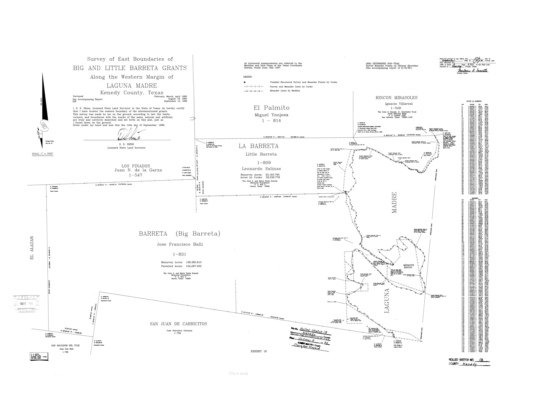
Kenedy County Rolled Sketch 18
Survey of east boundaries of Big and Little Barreta grants along the western margin of Laguna Madre, Kenedy County, Texas
-
Map/Doc
6472
-
Collection
General Map Collection
-
Object Dates
9/14/1995 (Creation Date)
10/5/1995 (File Date)
4/1993 (Survey Date)
-
People and Organizations
D.D. Shine (Surveyor/Engineer)
-
Counties
Kenedy
-
Subjects
Surveying Rolled Sketch
-
Height x Width
29.5 x 39.2 inches
74.9 x 99.6 cm
-
Medium
mylar, print
-
Scale
1" = 5000 feet
-
Comments
See Kenedy County Sketch File 2 (28773) for report.
Related maps
Kenedy County Sketch File 2

Print $130.00
- Digital $50.00
Kenedy County Sketch File 2
1995
Size 11.2 x 8.7 inches
Map/Doc 28773
Part of: General Map Collection
Hutchinson County Working Sketch 25

Print $20.00
- Digital $50.00
Hutchinson County Working Sketch 25
1972
Size 21.5 x 25.0 inches
Map/Doc 66385
Red River, Levee Improvement Districts Widths of Floodways - Bois D'Arc Creek

Print $20.00
- Digital $50.00
Red River, Levee Improvement Districts Widths of Floodways - Bois D'Arc Creek
1921
Size 29.5 x 26.0 inches
Map/Doc 65271
El Paso County Rolled Sketch 52

Print $20.00
- Digital $50.00
El Paso County Rolled Sketch 52
1930
Size 18.5 x 24.4 inches
Map/Doc 5837

Map of Leon County

Print $40.00
- Digital $50.00
Map of Leon County
Size 49.7 x 42.0 inches
Map/Doc 66900
Stephens County Working Sketch 41

Print $40.00
- Digital $50.00
Stephens County Working Sketch 41
2008
Size 34.1 x 48.0 inches
Map/Doc 88737
Brazoria County Sketch File 18

Print $18.00
- Digital $50.00
Brazoria County Sketch File 18
Size 14.5 x 8.9 inches
Map/Doc 14989
Visitor's Guide to Mexico City, D.F. [and Index to Cities and Villages and Route Summaries]
![96822, Visitor's Guide to Mexico City, D.F. [and Index to Cities and Villages and Route Summaries], General Map Collection](https://historictexasmaps.com/wmedia_w700/maps/96822.tif.jpg)
Visitor's Guide to Mexico City, D.F. [and Index to Cities and Villages and Route Summaries]
1999
Size 33.7 x 25.1 inches
Map/Doc 96822
Flight Mission No. BRA-7M, Frame 207, Jefferson County

Print $20.00
- Digital $50.00
Flight Mission No. BRA-7M, Frame 207, Jefferson County
1953
Size 18.6 x 22.3 inches
Map/Doc 85575
Navarro County

Print $40.00
- Digital $50.00
Navarro County
1924
Size 42.5 x 49.0 inches
Map/Doc 95599
Flight Mission No. DAG-18K, Frame 77, Matagorda County

Print $20.00
- Digital $50.00
Flight Mission No. DAG-18K, Frame 77, Matagorda County
1952
Size 18.5 x 22.3 inches
Map/Doc 86370
Brewster County Rolled Sketch 92

Print $20.00
- Digital $50.00
Brewster County Rolled Sketch 92
1950
Size 24.3 x 15.2 inches
Map/Doc 5250
You may also like
Gonzales County Boundary File 2

Print $7.00
- Digital $50.00
Gonzales County Boundary File 2
Size 14.4 x 9.0 inches
Map/Doc 53829
Baylor County Sketch File 14

Print $4.00
- Digital $50.00
Baylor County Sketch File 14
1879
Size 13.0 x 8.2 inches
Map/Doc 14181
Jackson County Sketch File 21

Print $70.00
- Digital $50.00
Jackson County Sketch File 21
2000
Size 11.3 x 8.8 inches
Map/Doc 27673
Map of Coleman County

Print $20.00
- Digital $50.00
Map of Coleman County
1878
Size 23.9 x 20.3 inches
Map/Doc 3412
[Map of T&P Blocks 1 and 2 in Jeff Davis and Presidio Counties]
![88959, [Map of T&P Blocks 1 and 2 in Jeff Davis and Presidio Counties], Library of Congress](https://historictexasmaps.com/wmedia_w700/maps/88959.tif.jpg)
Print $20.00
[Map of T&P Blocks 1 and 2 in Jeff Davis and Presidio Counties]
Size 22.2 x 17.3 inches
Map/Doc 88959
Galveston County

Print $40.00
- Digital $50.00
Galveston County
1939
Size 45.0 x 56.5 inches
Map/Doc 95505
Jackson County Working Sketch 10

Print $20.00
- Digital $50.00
Jackson County Working Sketch 10
1991
Size 35.9 x 36.1 inches
Map/Doc 66458
[Sketch of surveys north of Jefferson County School Land]
![91890, [Sketch of surveys north of Jefferson County School Land], Twichell Survey Records](https://historictexasmaps.com/wmedia_w700/maps/91890-1.tif.jpg)
Print $3.00
- Digital $50.00
[Sketch of surveys north of Jefferson County School Land]
1891
Size 10.3 x 11.2 inches
Map/Doc 91890
United States - Gulf Coast - Padre I. and Laguna Madre Lat. 27° 12' to Lat. 26° 33' Texas

Print $20.00
- Digital $50.00
United States - Gulf Coast - Padre I. and Laguna Madre Lat. 27° 12' to Lat. 26° 33' Texas
1913
Size 26.8 x 18.2 inches
Map/Doc 72815
Wichita County Working Sketch 12a

Print $20.00
- Digital $50.00
Wichita County Working Sketch 12a
1920
Size 20.2 x 14.1 inches
Map/Doc 72521
Right of Way and Track Map, the Missouri, Kansas and Texas Ry. of Texas operated by the Missouri, Kansas and Texas Ry. of Texas, San Antonio Division

Print $40.00
- Digital $50.00
Right of Way and Track Map, the Missouri, Kansas and Texas Ry. of Texas operated by the Missouri, Kansas and Texas Ry. of Texas, San Antonio Division
1918
Size 25.6 x 58.7 inches
Map/Doc 64581
Working Sketch of Surveys in Kent & Scurry Counties Located South of Clairemont, Texas

Print $20.00
- Digital $50.00
Working Sketch of Surveys in Kent & Scurry Counties Located South of Clairemont, Texas
1947
Size 41.2 x 43.4 inches
Map/Doc 89861