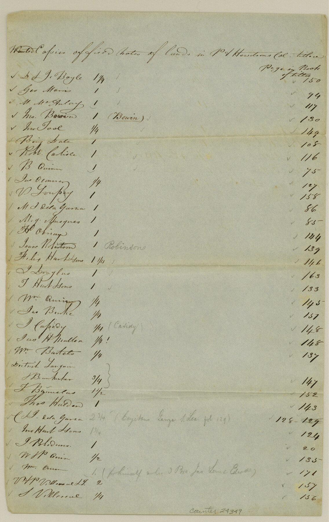
Goliad County Sketch File 42
[List of field notes sent to County Surveyor of surveys in Power and Hewetson's Colony]
-
Map/Doc
24349
-
Collection
General Map Collection
-
Object Dates
1847 (Creation Date)
1984/12/7 (File Date)
-
Counties
Goliad
-
Subjects
Surveying Sketch File
-
Height x Width
13.0 x 8.2 inches
33.0 x 20.8 cm
-
Medium
paper, manuscript
-
Features
Power & Hewetson's Colony
Part of: General Map Collection
Matagorda County Rolled Sketch 37A

Print $40.00
- Digital $50.00
Matagorda County Rolled Sketch 37A
Size 48.7 x 41.1 inches
Map/Doc 10195
Map of Calhoun County Texas

Print $20.00
- Digital $50.00
Map of Calhoun County Texas
1911
Size 27.7 x 34.3 inches
Map/Doc 4514
Aransas County Sketch File 25

Print $20.00
- Digital $50.00
Aransas County Sketch File 25
Size 17.0 x 17.5 inches
Map/Doc 13218
Pecos County Sketch File 76A

Print $20.00
- Digital $50.00
Pecos County Sketch File 76A
Size 16.1 x 18.3 inches
Map/Doc 12182
Southern Part of Laguna Madre

Print $20.00
- Digital $50.00
Southern Part of Laguna Madre
1949
Size 44.5 x 35.4 inches
Map/Doc 73535
Medina County Sketch File 11

Print $14.00
- Digital $50.00
Medina County Sketch File 11
1907
Size 10.4 x 6.6 inches
Map/Doc 31461
Flight Mission No. DAG-19K, Frame 56, Matagorda County

Print $20.00
- Digital $50.00
Flight Mission No. DAG-19K, Frame 56, Matagorda County
1952
Size 18.5 x 22.3 inches
Map/Doc 86383
Kaufman County Working Sketch 4

Print $40.00
- Digital $50.00
Kaufman County Working Sketch 4
1922
Size 52.1 x 36.2 inches
Map/Doc 66667
Borden County Working Sketch 2

Print $20.00
- Digital $50.00
Borden County Working Sketch 2
1913
Size 24.6 x 18.4 inches
Map/Doc 67462
Terrell County Working Sketch 76

Print $20.00
- Digital $50.00
Terrell County Working Sketch 76
1982
Size 31.8 x 20.1 inches
Map/Doc 69597
Upshur County Working Sketch 10a

Print $20.00
- Digital $50.00
Upshur County Working Sketch 10a
1969
Size 15.8 x 18.7 inches
Map/Doc 69567
Gray County Sketch File 3

Print $6.00
- Digital $50.00
Gray County Sketch File 3
1885
Size 12.9 x 8.3 inches
Map/Doc 24415
You may also like
Burnet County Sketch File 14a

Print $6.00
- Digital $50.00
Burnet County Sketch File 14a
Size 17.0 x 11.0 inches
Map/Doc 16700
[Maps of surveys in Reeves & Culberson Cos]
![61129, [Maps of surveys in Reeves & Culberson Cos], General Map Collection](https://historictexasmaps.com/wmedia_w700/maps/61129.tif.jpg)
Print $20.00
- Digital $50.00
[Maps of surveys in Reeves & Culberson Cos]
1937
Size 30.7 x 25.0 inches
Map/Doc 61129
Karte von Indian Point od Indianola / Karte der Stadt Neu Braunfels / Karte der Stadt Friedrichsburg / Hafen von Indian Point oder Indianola (Carlshafen) [Four map insets]
![79297, Karte von Indian Point od Indianola / Karte der Stadt Neu Braunfels / Karte der Stadt Friedrichsburg / Hafen von Indian Point oder Indianola (Carlshafen) [Four map insets], Texas State Library and Archives](https://historictexasmaps.com/wmedia_w700/maps/79297.tif.jpg)
Print $20.00
Karte von Indian Point od Indianola / Karte der Stadt Neu Braunfels / Karte der Stadt Friedrichsburg / Hafen von Indian Point oder Indianola (Carlshafen) [Four map insets]
1850
Size 13.3 x 19.4 inches
Map/Doc 79297
Duval County Sketch File 4b

Print $4.00
- Digital $50.00
Duval County Sketch File 4b
1874
Size 10.4 x 7.8 inches
Map/Doc 21282
Flight Mission No. BRA-7M, Frame 23, Jefferson County

Print $20.00
- Digital $50.00
Flight Mission No. BRA-7M, Frame 23, Jefferson County
1953
Size 18.6 x 22.4 inches
Map/Doc 85474
Flight Mission No. DAG-14K, Frame 134, Matagorda County

Print $20.00
- Digital $50.00
Flight Mission No. DAG-14K, Frame 134, Matagorda County
1952
Size 17.6 x 17.4 inches
Map/Doc 86305
Zapata County Rolled Sketch 7A

Print $20.00
- Digital $50.00
Zapata County Rolled Sketch 7A
1912
Size 17.9 x 26.6 inches
Map/Doc 8309
Flight Mission No. DAG-23K, Frame 178, Matagorda County

Print $20.00
- Digital $50.00
Flight Mission No. DAG-23K, Frame 178, Matagorda County
1953
Size 18.8 x 22.5 inches
Map/Doc 86513
Hardin County Sketch File 47

Print $4.00
- Digital $50.00
Hardin County Sketch File 47
1875
Size 7.2 x 7.2 inches
Map/Doc 25200
Tarrant County Working Sketch 19

Print $20.00
- Digital $50.00
Tarrant County Working Sketch 19
1999
Size 11.8 x 18.1 inches
Map/Doc 62436
[Sketch Showing Wm. T. Brewer, John R. Taylor, Wm. F. Butler, Timothy DeVore, L. M. Thorn and adjoining surveys]
![90230, [Sketch Showing Wm. T. Brewer, John R. Taylor, Wm. F. Butler, Timothy DeVore, L. M. Thorn and adjoining surveys], Twichell Survey Records](https://historictexasmaps.com/wmedia_w700/maps/90230-1.tif.jpg)
Print $20.00
- Digital $50.00
[Sketch Showing Wm. T. Brewer, John R. Taylor, Wm. F. Butler, Timothy DeVore, L. M. Thorn and adjoining surveys]
Size 25.1 x 19.2 inches
Map/Doc 90230
Galveston County NRC Article 33.136 Sketch 49

Print $24.00
- Digital $50.00
Galveston County NRC Article 33.136 Sketch 49
2007
Size 24.0 x 36.0 inches
Map/Doc 94663