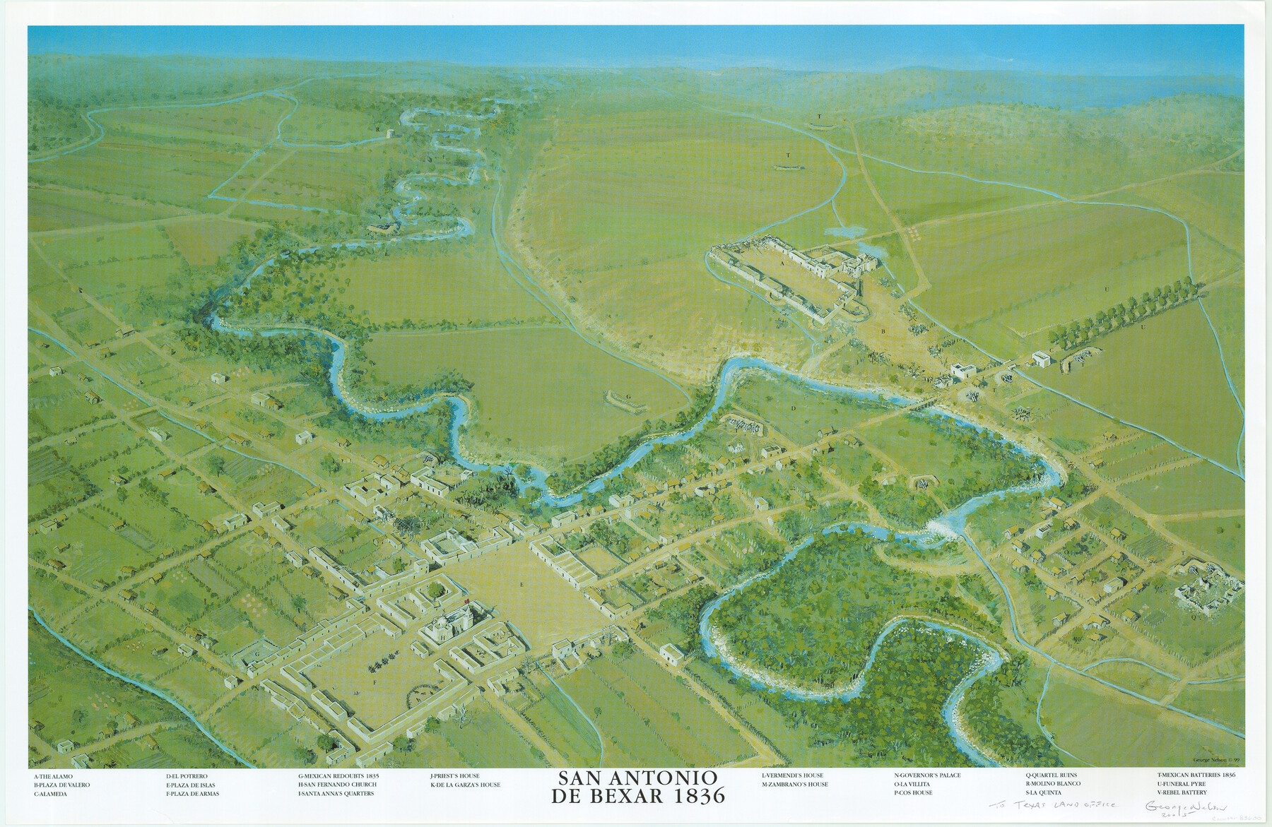
San Antonio de Bexar 1836
-
Map/Doc
83600
-
Collection
General Map Collection
-
Object Dates
1999 (Creation Date)
2006/4/28 (File Date)
-
People and Organizations
George Nelson (Publisher)
George Nelson (Author)
-
Counties
Bexar
-
Subjects
City
-
Height x Width
21.9 x 33.6 inches
55.6 x 85.3 cm
-
Medium
paper, print
-
Comments
Presented to the Texas General Land Office by George Nelson in 2005.
Copyrighted 1999 and unavailable for duplication. For research use only. -
Features
San Antonio
The Alamo
Plaza de Valero
Alameda
Plaza de Islas
Plaza de Armas
San Fernando Church
Priest's House
Cos House
Quartel Ruins
De la Garza's House
Vermendi's House
Zambrano's House
La Villita
Part of: General Map Collection
[Drawings of individual counties for Pressler and Langermann's 1879 Map of Texas]
![[Drawings of individual counties for Pressler and Langermann's 1879 Map of Texas]](https://historictexasmaps.com/wmedia_w700/maps/4864.tif.jpg)
Print $20.00
- Digital $50.00
[Drawings of individual counties for Pressler and Langermann's 1879 Map of Texas]
1878
Size 38.3 x 26.8 inches
Map/Doc 4864
Flight Mission No. CUG-2P, Frame 77, Kleberg County

Print $20.00
- Digital $50.00
Flight Mission No. CUG-2P, Frame 77, Kleberg County
1956
Size 18.6 x 22.3 inches
Map/Doc 86209
Tom Green County

Print $20.00
- Digital $50.00
Tom Green County
1856
Size 23.3 x 27.7 inches
Map/Doc 4089
Rusk County Working Sketch 38

Print $20.00
- Digital $50.00
Rusk County Working Sketch 38
2008
Size 16.3 x 23.3 inches
Map/Doc 88815
Wilbarger Co.

Print $20.00
- Digital $50.00
Wilbarger Co.
1949
Size 47.8 x 38.8 inches
Map/Doc 73324
San Jacinto County Rolled Sketch 5

Print $20.00
- Digital $50.00
San Jacinto County Rolled Sketch 5
Size 13.7 x 18.6 inches
Map/Doc 8386
Menard County Working Sketch 12

Print $20.00
- Digital $50.00
Menard County Working Sketch 12
1939
Size 24.7 x 30.0 inches
Map/Doc 70959
Red River County Working Sketch 68

Print $20.00
- Digital $50.00
Red River County Working Sketch 68
1975
Size 20.8 x 26.0 inches
Map/Doc 72051
Harris County Sketch File 52

Print $20.00
- Digital $50.00
Harris County Sketch File 52
1914
Size 21.7 x 26.0 inches
Map/Doc 11653
Kimble County Sketch File 2

Print $2.00
- Digital $50.00
Kimble County Sketch File 2
Size 7.0 x 6.7 inches
Map/Doc 28909
Jack County Sketch File 16

Print $4.00
- Digital $50.00
Jack County Sketch File 16
1877
Size 7.9 x 12.8 inches
Map/Doc 27549
[Surveys in the Bexar District along the Atascosa Creek]
![221, [Surveys in the Bexar District along the Atascosa Creek], General Map Collection](https://historictexasmaps.com/wmedia_w700/maps/221.tif.jpg)
Print $2.00
- Digital $50.00
[Surveys in the Bexar District along the Atascosa Creek]
1842
Size 5.9 x 5.9 inches
Map/Doc 221
You may also like
Midland County Working Sketch 20

Print $20.00
- Digital $50.00
Midland County Working Sketch 20
1953
Size 22.0 x 14.9 inches
Map/Doc 71001
San Jacinto County Rolled Sketch 13

Print $20.00
- Digital $50.00
San Jacinto County Rolled Sketch 13
1994
Size 32.2 x 23.7 inches
Map/Doc 7562
Angelina County Working Sketch 37

Print $20.00
- Digital $50.00
Angelina County Working Sketch 37
1958
Size 25.7 x 19.1 inches
Map/Doc 67120
Brewster County Rolled Sketch 104

Print $40.00
- Digital $50.00
Brewster County Rolled Sketch 104
1938
Size 68.3 x 45.3 inches
Map/Doc 8511
Gillespie County Sketch File 3

Print $4.00
- Digital $50.00
Gillespie County Sketch File 3
1847
Size 11.2 x 8.0 inches
Map/Doc 24129
Capitol Land and Investment Company's List of Texas Lands

Capitol Land and Investment Company's List of Texas Lands
1907
Size 7.9 x 5.2 inches
Map/Doc 97052
[Galveston, Harrisburg & San Antonio Railway]
![64408, [Galveston, Harrisburg & San Antonio Railway], General Map Collection](https://historictexasmaps.com/wmedia_w700/maps/64408.tif.jpg)
Print $20.00
- Digital $50.00
[Galveston, Harrisburg & San Antonio Railway]
1892
Size 13.5 x 33.6 inches
Map/Doc 64408
Val Verde County Sketch File XX

Print $20.00
- Digital $50.00
Val Verde County Sketch File XX
Size 14.5 x 16.7 inches
Map/Doc 12546
Flight Mission No. BRA-17M, Frame 17, Jefferson County

Print $20.00
- Digital $50.00
Flight Mission No. BRA-17M, Frame 17, Jefferson County
1953
Size 18.5 x 22.3 inches
Map/Doc 85798
Flight Mission No. BQY-15M, Frame 7, Harris County

Print $20.00
- Digital $50.00
Flight Mission No. BQY-15M, Frame 7, Harris County
1953
Size 18.5 x 22.4 inches
Map/Doc 85305
Map of Caldwell County

Print $20.00
- Digital $50.00
Map of Caldwell County
1871
Size 17.2 x 19.8 inches
Map/Doc 3357
Prison Property, Walker Co.

Print $20.00
- Digital $50.00
Prison Property, Walker Co.
Size 24.4 x 23.5 inches
Map/Doc 62976