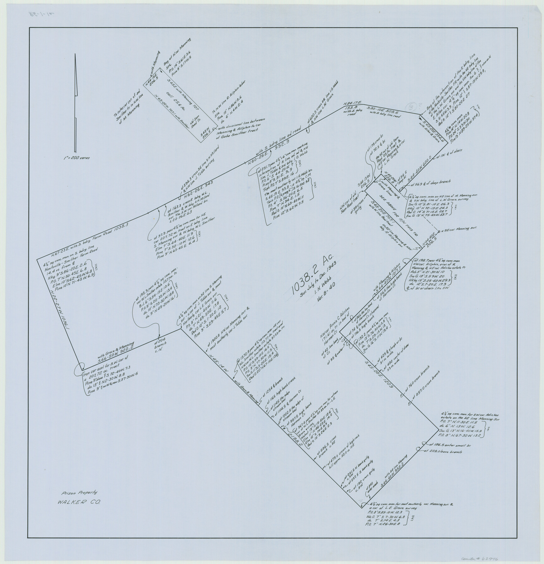
Prison Property, Walker Co.
RG-1-1a
-
Map/Doc
62976
-
Collection
General Map Collection
-
Counties
Walker
-
Height x Width
24.4 x 23.5 inches
62.0 x 59.7 cm
Part of: General Map Collection
Tom Green County Sketch File 81

Print $20.00
- Digital $50.00
Tom Green County Sketch File 81
Size 16.6 x 23.4 inches
Map/Doc 12453
Brewster County Rolled Sketch 59CC

Print $20.00
- Digital $50.00
Brewster County Rolled Sketch 59CC
1939
Size 18.3 x 24.9 inches
Map/Doc 5230
Webb County Rolled Sketch 79

Print $20.00
- Digital $50.00
Webb County Rolled Sketch 79
2020
Size 35.7 x 24.9 inches
Map/Doc 95916
Bowie County Working Sketch Graphic Index

Print $20.00
- Digital $50.00
Bowie County Working Sketch Graphic Index
1933
Size 38.9 x 47.1 inches
Map/Doc 76470

Cameron County Rolled Sketch 20D

Print $20.00
- Digital $50.00
Cameron County Rolled Sketch 20D
Size 14.3 x 13.9 inches
Map/Doc 5477
Crockett County Rolled Sketch 79

Print $40.00
- Digital $50.00
Crockett County Rolled Sketch 79
1954
Size 37.3 x 48.3 inches
Map/Doc 8724
Copy of connection made by E. Sewell

Print $2.00
- Digital $50.00
Copy of connection made by E. Sewell
1841
Size 9.4 x 9.0 inches
Map/Doc 161
Harris County Historic Topographic 28

Print $20.00
- Digital $50.00
Harris County Historic Topographic 28
1915
Size 29.5 x 22.8 inches
Map/Doc 65839
[Sketch for Mineral Application 27669 - Trinity River, Frank R. Graves]
![2860, [Sketch for Mineral Application 27669 - Trinity River, Frank R. Graves], General Map Collection](https://historictexasmaps.com/wmedia_w700/maps/2860-1.tif.jpg)
Print $20.00
- Digital $50.00
[Sketch for Mineral Application 27669 - Trinity River, Frank R. Graves]
1934
Size 27.4 x 42.7 inches
Map/Doc 2860
Orange County NRC Article 33.136 Sketch 4

Print $24.00
- Digital $50.00
Orange County NRC Article 33.136 Sketch 4
2011
Size 22.6 x 31.2 inches
Map/Doc 93271
Gregg County Rolled Sketch 26

Print $40.00
- Digital $50.00
Gregg County Rolled Sketch 26
1937
Size 26.4 x 126.6 inches
Map/Doc 76432
You may also like
Borden County Working Sketch 14

Print $20.00
- Digital $50.00
Borden County Working Sketch 14
1959
Size 27.8 x 25.2 inches
Map/Doc 67474
Ochiltree County Boundary File 4

Print $4.00
- Digital $50.00
Ochiltree County Boundary File 4
Size 11.1 x 8.7 inches
Map/Doc 57682
Flight Mission No. CGI-4N, Frame 182, Cameron County

Print $20.00
- Digital $50.00
Flight Mission No. CGI-4N, Frame 182, Cameron County
1955
Size 18.4 x 22.2 inches
Map/Doc 84685
Hudspeth County Rolled Sketch 25

Print $20.00
- Digital $50.00
Hudspeth County Rolled Sketch 25
1909
Size 18.0 x 20.7 inches
Map/Doc 6245
Culberson County Rolled Sketch 11
Print $20.00
- Digital $50.00
Culberson County Rolled Sketch 11
1898
Size 25.6 x 45.9 inches
Map/Doc 5648
[S51-58, 27, 30, 303-306, 221-224, 562, 564]
![92185, [S51-58, 27, 30, 303-306, 221-224, 562, 564], Twichell Survey Records](https://historictexasmaps.com/wmedia_w700/maps/92185-1.tif.jpg)
Print $20.00
- Digital $50.00
[S51-58, 27, 30, 303-306, 221-224, 562, 564]
Size 31.1 x 15.6 inches
Map/Doc 92185
[Gulf Coast of Texas]
![72701, [Gulf Coast of Texas], General Map Collection](https://historictexasmaps.com/wmedia_w700/maps/72701.tif.jpg)
Print $20.00
- Digital $50.00
[Gulf Coast of Texas]
1881
Size 18.2 x 28.5 inches
Map/Doc 72701
Glasscock County Rolled Sketch 1

Print $20.00
- Digital $50.00
Glasscock County Rolled Sketch 1
1906
Size 37.3 x 33.6 inches
Map/Doc 9055
Jasper County Rolled Sketch 4

Print $20.00
- Digital $50.00
Jasper County Rolled Sketch 4
1947
Size 40.0 x 31.1 inches
Map/Doc 6351
Flight Mission No. DAG-24K, Frame 140, Matagorda County

Print $20.00
- Digital $50.00
Flight Mission No. DAG-24K, Frame 140, Matagorda County
1953
Size 17.0 x 15.6 inches
Map/Doc 86558
Laneer vs. Bivins, Potter County, Texas

Print $20.00
- Digital $50.00
Laneer vs. Bivins, Potter County, Texas
Size 21.1 x 18.8 inches
Map/Doc 93062
[F. W. & D. C. Ry. Co. Alignment and Right of Way Map, Clay County]
![64734, [F. W. & D. C. Ry. Co. Alignment and Right of Way Map, Clay County], General Map Collection](https://historictexasmaps.com/wmedia_w700/maps/64734-GC.tif.jpg)
Print $20.00
- Digital $50.00
[F. W. & D. C. Ry. Co. Alignment and Right of Way Map, Clay County]
1927
Size 18.6 x 11.8 inches
Map/Doc 64734