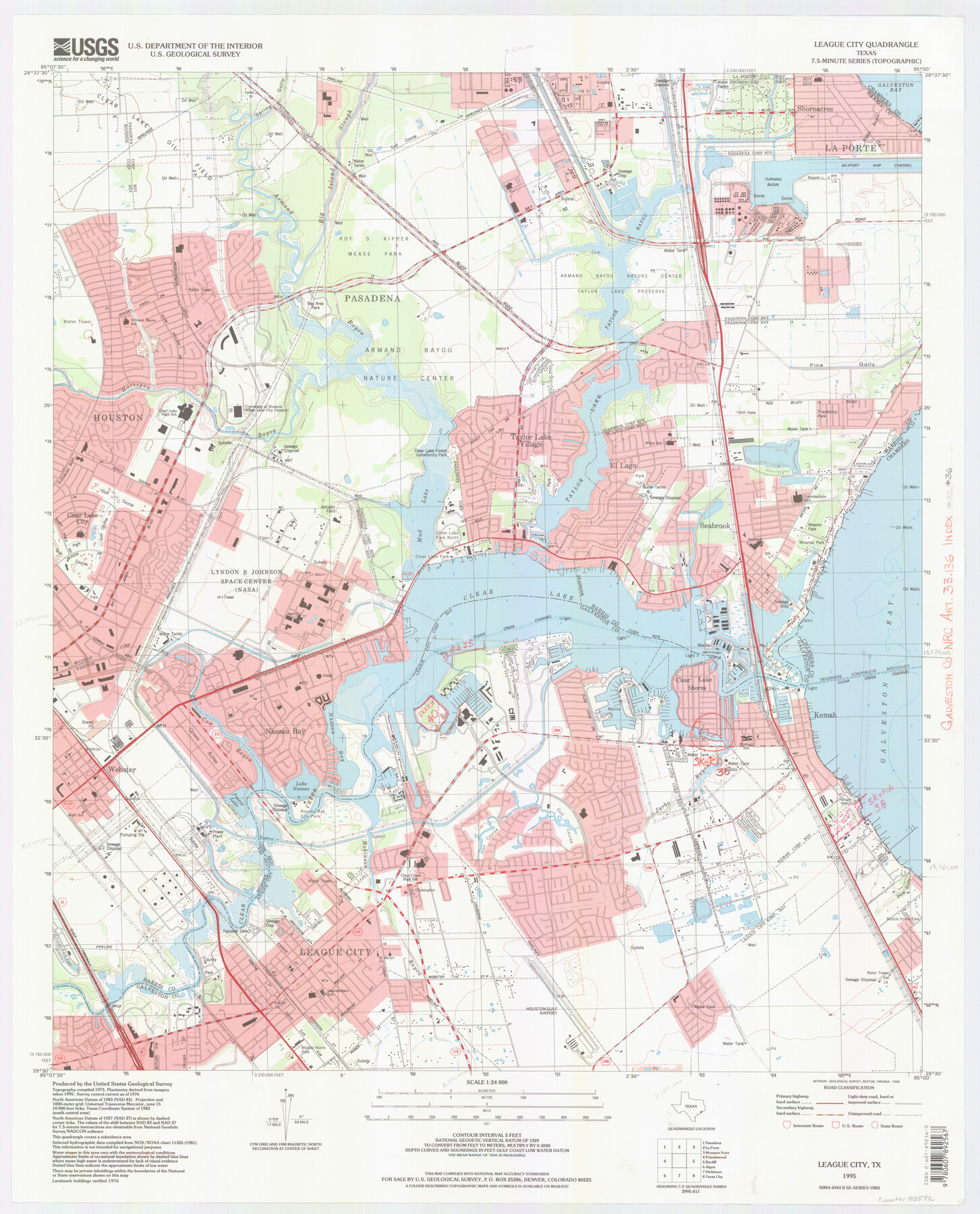
Galveston County NRC Article 33.136 Location Key Sheet
Smith Point Quadrangle
-
Map/Doc
83592
-
Collection
General Map Collection
-
Object Dates
1995 (Creation Date)
-
People and Organizations
U. S. Geological Survey (Publisher)
U. S. Geological Survey (Printer)
-
Counties
Galveston
-
Subjects
Surveying CBS
-
Height x Width
27.0 x 22.0 inches
68.6 x 55.9 cm
Part of: General Map Collection
Presidio County Working Sketch 130

Print $20.00
- Digital $50.00
Presidio County Working Sketch 130
1989
Size 22.1 x 43.1 inches
Map/Doc 71808

Titus County Sketch File 7

Print $4.00
- Digital $50.00
Titus County Sketch File 7
1853
Size 10.0 x 8.2 inches
Map/Doc 38142
Carson County Boundary File 5c

Print $10.00
- Digital $50.00
Carson County Boundary File 5c
Size 14.2 x 8.7 inches
Map/Doc 51146
[Titles along the Trinity River]
![175, [Titles along the Trinity River], General Map Collection](https://historictexasmaps.com/wmedia_w700/maps/175.tif.jpg)
Print $3.00
- Digital $50.00
[Titles along the Trinity River]
Size 10.6 x 15.8 inches
Map/Doc 175
Hays County Working Sketch 15

Print $40.00
- Digital $50.00
Hays County Working Sketch 15
1965
Size 39.8 x 51.6 inches
Map/Doc 66089
Orange County Working Sketch 16

Print $20.00
- Digital $50.00
Orange County Working Sketch 16
1929
Size 25.0 x 24.2 inches
Map/Doc 71348
Mason County Sketch File 11

Print $8.00
- Digital $50.00
Mason County Sketch File 11
1883
Size 13.5 x 8.6 inches
Map/Doc 30695
El Paso County Boundary File 7a

Print $20.00
- Digital $50.00
El Paso County Boundary File 7a
Size 14.2 x 8.3 inches
Map/Doc 53094
San Jacinto County Working Sketch 11

Print $20.00
- Digital $50.00
San Jacinto County Working Sketch 11
1935
Size 40.1 x 40.0 inches
Map/Doc 63724
Dawson County Sketch File 13

Print $2.00
- Digital $50.00
Dawson County Sketch File 13
Size 11.2 x 8.6 inches
Map/Doc 20546

You may also like
General Highway Map, Runnels County, Texas

Print $20.00
General Highway Map, Runnels County, Texas
1940
Size 24.7 x 18.3 inches
Map/Doc 79231
Greenville, Tex., County Seat of Hunt County, 1886

Print $20.00
Greenville, Tex., County Seat of Hunt County, 1886
1886
Size 20.4 x 28.3 inches
Map/Doc 93476
San Augustine County Working Sketch 11b

Print $20.00
- Digital $50.00
San Augustine County Working Sketch 11b
Size 18.9 x 26.3 inches
Map/Doc 63699
Lipscomb County Rolled Sketch 5

Print $40.00
- Digital $50.00
Lipscomb County Rolled Sketch 5
Size 60.5 x 8.0 inches
Map/Doc 81427
Hale County Boundary File 1

Print $44.00
- Digital $50.00
Hale County Boundary File 1
Size 10.0 x 30.9 inches
Map/Doc 54031
Texas Gulf Coast Map from the Sabine River to the Rio Grande as subdivided for mineral development

Print $40.00
- Digital $50.00
Texas Gulf Coast Map from the Sabine River to the Rio Grande as subdivided for mineral development
1948
Size 42.6 x 54.3 inches
Map/Doc 2907
Duval County Rolled Sketch E

Print $20.00
- Digital $50.00
Duval County Rolled Sketch E
1935
Size 36.4 x 37.7 inches
Map/Doc 8808
Bastrop County Working Sketch 8

Print $20.00
- Digital $50.00
Bastrop County Working Sketch 8
1937
Size 23.9 x 43.1 inches
Map/Doc 67308
Real County Working Sketch 88

Print $20.00
- Digital $50.00
Real County Working Sketch 88
1989
Size 23.9 x 27.0 inches
Map/Doc 71980
Pecos County Working Sketch 50

Print $20.00
- Digital $50.00
Pecos County Working Sketch 50
1947
Size 21.1 x 13.4 inches
Map/Doc 71522
Brewster County Working Sketch 41

Print $20.00
- Digital $50.00
Brewster County Working Sketch 41
1945
Size 30.3 x 38.4 inches
Map/Doc 67575
[Working Sketch of a portion of Hidalgo & Starr Co's.]
![4447, [Working Sketch of a portion of Hidalgo & Starr Co's.], Maddox Collection](https://historictexasmaps.com/wmedia_w700/maps/4447.tif.jpg)
Print $20.00
- Digital $50.00
[Working Sketch of a portion of Hidalgo & Starr Co's.]
1906
Size 27.8 x 13.8 inches
Map/Doc 4447