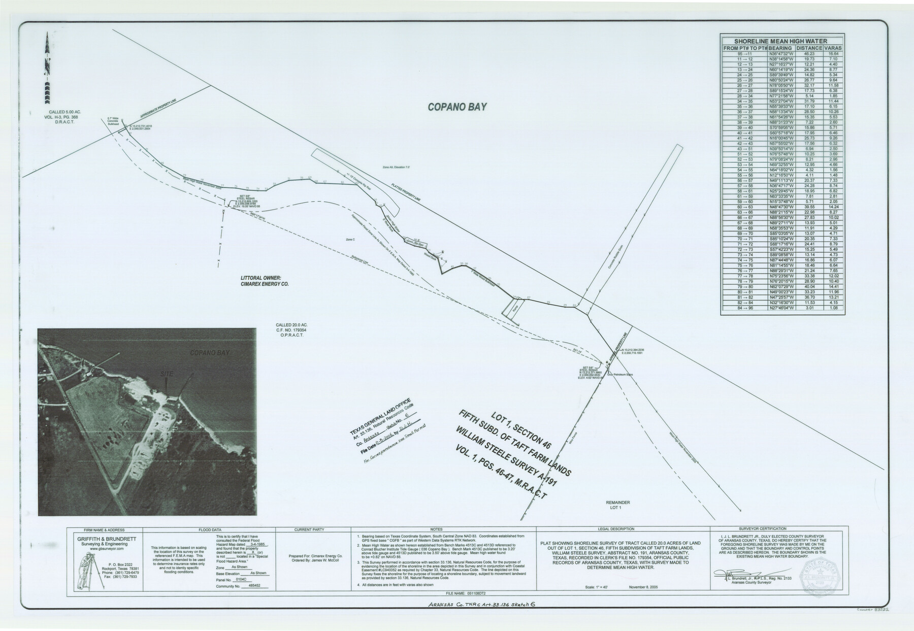
Aransas County NRC Article 33.136 Sketch 6
A Shoreline Survey of Tract Called 20.0 Acres of Land Out of Lot 1, Section 46, Fifth Subdivision of Taft Farm Land, William Steele Survey, Abstract 191
-
Map/Doc
83522
-
Collection
General Map Collection
-
Object Dates
2005/11/8 (Creation Date)
2006/2/8 (File Date)
-
People and Organizations
Griffith and Brundrett Surveying & Engineering (Publisher)
Griffith and Brundrett Surveying & Engineering (Printer)
J.L. Brundrett Jr. (Surveyor/Engineer)
-
Counties
Aransas
-
Subjects
Surveying CBS
-
Height x Width
25.1 x 36.4 inches
63.8 x 92.5 cm
-
Medium
multi-page, multi-format
-
Comments
Survey located about nine miles North 71 degrees West of Rockport, Texas.
Part of: General Map Collection
Outer Continental Shelf Leasing Maps (Louisiana Offshore Operations)

Print $20.00
- Digital $50.00
Outer Continental Shelf Leasing Maps (Louisiana Offshore Operations)
1955
Size 20.2 x 15.1 inches
Map/Doc 75858
Hardin County Working Sketch 22

Print $20.00
- Digital $50.00
Hardin County Working Sketch 22
1948
Size 20.9 x 31.6 inches
Map/Doc 63420
Flight Mission No. BRE-1P, Frame 127, Nueces County

Print $20.00
- Digital $50.00
Flight Mission No. BRE-1P, Frame 127, Nueces County
1956
Size 18.7 x 22.6 inches
Map/Doc 86693
Walker County Sketch File 5

Print $4.00
- Digital $50.00
Walker County Sketch File 5
Size 13.5 x 8.3 inches
Map/Doc 39555
Flight Mission No. CGI-3N, Frame 122, Cameron County

Print $20.00
- Digital $50.00
Flight Mission No. CGI-3N, Frame 122, Cameron County
1954
Size 18.6 x 22.2 inches
Map/Doc 84595
Trinity County Sketch File 24

Print $4.00
- Digital $50.00
Trinity County Sketch File 24
Size 7.5 x 10.5 inches
Map/Doc 38556
Goliad County Sketch File 16

Print $40.00
- Digital $50.00
Goliad County Sketch File 16
Size 13.4 x 15.8 inches
Map/Doc 24247
Starr County Sketch File 22

Print $20.00
- Digital $50.00
Starr County Sketch File 22
1922
Size 16.4 x 35.9 inches
Map/Doc 12331
Henderson County Rolled Sketch 11

Print $20.00
- Digital $50.00
Henderson County Rolled Sketch 11
1915
Size 29.1 x 42.2 inches
Map/Doc 76150
Crosby County Working Sketch 13

Print $20.00
- Digital $50.00
Crosby County Working Sketch 13
1963
Size 17.9 x 30.7 inches
Map/Doc 68447
Map of the City of Dallas, Texas, compiled from the records of Dallas Co., and latest surveys of the City Engineer

Map of the City of Dallas, Texas, compiled from the records of Dallas Co., and latest surveys of the City Engineer
1878
Size 22.9 x 31.1 inches
Map/Doc 76174
Corpus Christi Bay

Print $20.00
- Digital $50.00
Corpus Christi Bay
1973
Size 36.6 x 47.7 inches
Map/Doc 73474
You may also like
Map of Texas and Pacific Ry. Company's Surveys in the 80 Mile Reserve

Print $20.00
- Digital $50.00
Map of Texas and Pacific Ry. Company's Surveys in the 80 Mile Reserve
1885
Size 44.0 x 46.6 inches
Map/Doc 83558
[H. & G. N. Block 1, Sections 128-130]
![90948, [H. & G. N. Block 1, Sections 128-130], Twichell Survey Records](https://historictexasmaps.com/wmedia_w700/maps/90948-1.tif.jpg)
Print $20.00
- Digital $50.00
[H. & G. N. Block 1, Sections 128-130]
Size 36.6 x 11.9 inches
Map/Doc 90948
Terrell County Working Sketch 3a

Print $20.00
- Digital $50.00
Terrell County Working Sketch 3a
1912
Size 26.1 x 21.2 inches
Map/Doc 62152
Webb County Boundary File 5

Print $165.00
- Digital $50.00
Webb County Boundary File 5
Size 14.2 x 8.8 inches
Map/Doc 59765
Pecos County Rolled Sketch 60

Print $20.00
- Digital $50.00
Pecos County Rolled Sketch 60
1926
Size 18.3 x 24.2 inches
Map/Doc 7232
Live Oak County Working Sketch 34

Print $20.00
- Digital $50.00
Live Oak County Working Sketch 34
Size 31.0 x 42.6 inches
Map/Doc 78469
[G. H. & H. Block 2]
![91894, [G. H. & H. Block 2], Twichell Survey Records](https://historictexasmaps.com/wmedia_w700/maps/91894-1.tif.jpg)
Print $20.00
- Digital $50.00
[G. H. & H. Block 2]
Size 20.6 x 18.4 inches
Map/Doc 91894

Flight Mission No. CUG-1P, Frame 158, Kleberg County

Print $20.00
- Digital $50.00
Flight Mission No. CUG-1P, Frame 158, Kleberg County
1956
Size 18.5 x 22.3 inches
Map/Doc 86165
Williamson County Sketch File 8a

Print $4.00
- Digital $50.00
Williamson County Sketch File 8a
1849
Size 10.4 x 8.3 inches
Map/Doc 40320
Val Verde County Working Sketch 117

Print $20.00
- Digital $50.00
Val Verde County Working Sketch 117
1993
Size 30.9 x 37.0 inches
Map/Doc 82844
[Sketch for Mineral Application 19560 - 19588 - San Bernard River]
![65579, [Sketch for Mineral Application 19560 - 19588 - San Bernard River], General Map Collection](https://historictexasmaps.com/wmedia_w700/maps/65579.tif.jpg)
Print $40.00
- Digital $50.00
[Sketch for Mineral Application 19560 - 19588 - San Bernard River]
1928
Size 33.0 x 98.6 inches
Map/Doc 65579