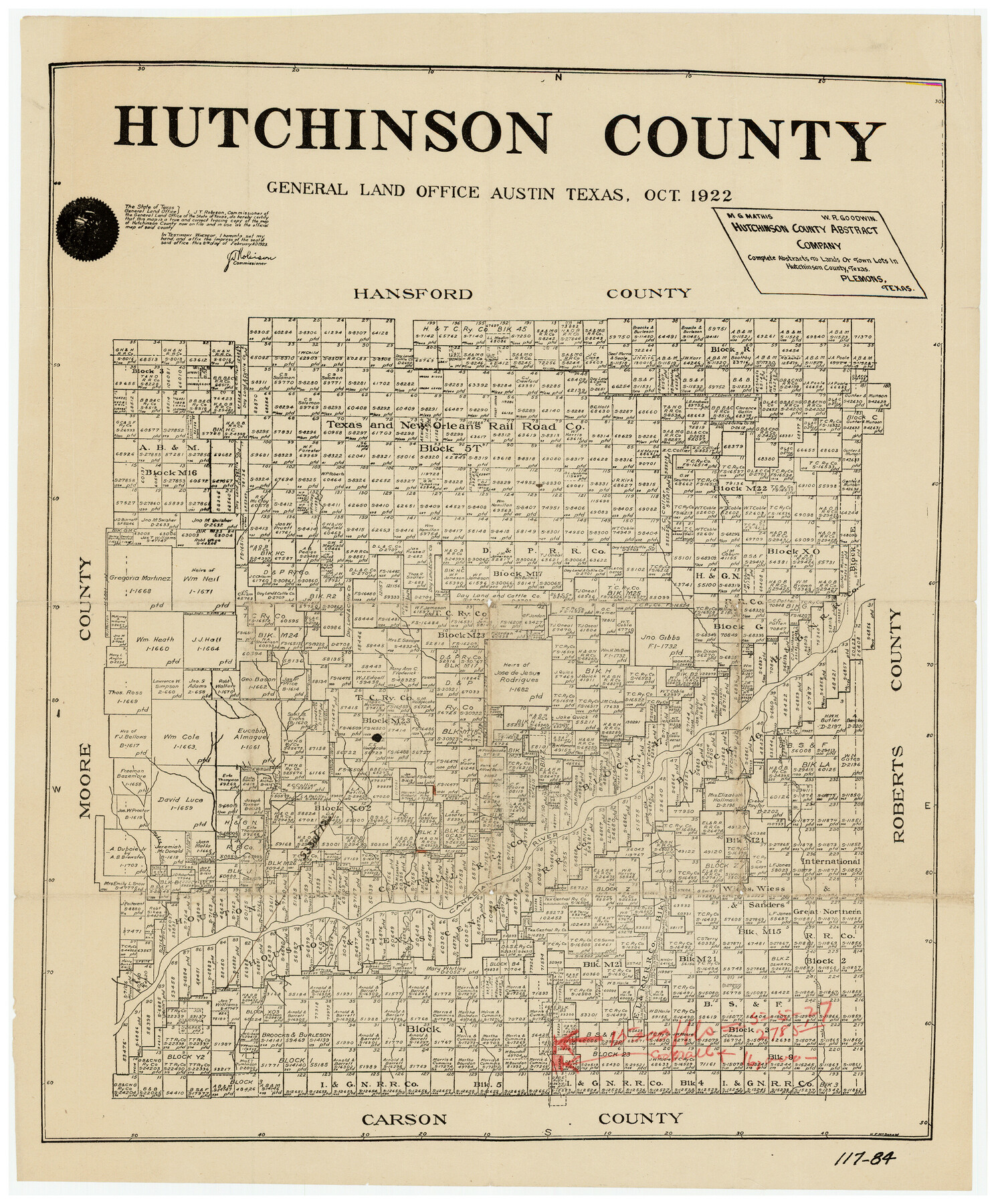
Hutchinson County
117-84
-
Map/Doc
91183
-
Collection
Twichell Survey Records
-
Object Dates
10/1922 (Creation Date)
-
Counties
Hutchinson
-
Subjects
County
-
Height x Width
14.6 x 17.6 inches
37.1 x 44.7 cm
Part of: Twichell Survey Records
Re-Subdivision of a Part of E. Dick Slaughter Lands Cochran County, Texas

Print $20.00
- Digital $50.00
Re-Subdivision of a Part of E. Dick Slaughter Lands Cochran County, Texas
Size 31.0 x 21.9 inches
Map/Doc 92482
[Part of Eastern Texas RR. Co. Block 1]
![91897, [Part of Eastern Texas RR. Co. Block 1], Twichell Survey Records](https://historictexasmaps.com/wmedia_w700/maps/91897-1.tif.jpg)
Print $20.00
- Digital $50.00
[Part of Eastern Texas RR. Co. Block 1]
Size 12.0 x 16.2 inches
Map/Doc 91897
[Plat map showing mostly Overton Addition]
![92812, [Plat map showing mostly Overton Addition], Twichell Survey Records](https://historictexasmaps.com/wmedia_w700/maps/92812-1.tif.jpg)
Print $20.00
- Digital $50.00
[Plat map showing mostly Overton Addition]
Size 31.9 x 31.3 inches
Map/Doc 92812
![92955, [Block 4X], Twichell Survey Records](https://historictexasmaps.com/wmedia_w700/maps/92955-1.tif.jpg)
[Sketch showing a stretch of T. & P. RR. Line between PSL Blocks B-15 and B-16]
![90902, [Sketch showing a stretch of T. & P. RR. Line between PSL Blocks B-15 and B-16], Twichell Survey Records](https://historictexasmaps.com/wmedia_w700/maps/90902-1.tif.jpg)
Print $20.00
- Digital $50.00
[Sketch showing a stretch of T. & P. RR. Line between PSL Blocks B-15 and B-16]
Size 37.9 x 25.5 inches
Map/Doc 90902
Map of Independence Area, Washington County, Texas

Print $20.00
- Digital $50.00
Map of Independence Area, Washington County, Texas
1935
Size 18.6 x 16.5 inches
Map/Doc 92093
[Blocks D3 and GP]
![91506, [Blocks D3 and GP], Twichell Survey Records](https://historictexasmaps.com/wmedia_w700/maps/91506-1.tif.jpg)
Print $20.00
- Digital $50.00
[Blocks D3 and GP]
Size 18.2 x 19.3 inches
Map/Doc 91506
Enochs Land situated in Bailey and Cochran Counties, Texas

Print $20.00
- Digital $50.00
Enochs Land situated in Bailey and Cochran Counties, Texas
Size 28.9 x 35.6 inches
Map/Doc 90194
[Three Positions Concluded, Exhibit F]
![91371, [Three Positions Concluded, Exhibit F], Twichell Survey Records](https://historictexasmaps.com/wmedia_w700/maps/91371-1.tif.jpg)
Print $20.00
- Digital $50.00
[Three Positions Concluded, Exhibit F]
Size 26.0 x 16.4 inches
Map/Doc 91371
Joe Bowman, Est. Irrigated Farm NW Quarter Section 11, Block E

Print $20.00
- Digital $50.00
Joe Bowman, Est. Irrigated Farm NW Quarter Section 11, Block E
1944
Size 16.4 x 18.5 inches
Map/Doc 92329
[Jose Ostane and Surrounding Surveys]
![91083, [Jose Ostane and Surrounding Surveys], Twichell Survey Records](https://historictexasmaps.com/wmedia_w700/maps/91083-1.tif.jpg)
Print $20.00
- Digital $50.00
[Jose Ostane and Surrounding Surveys]
Size 13.6 x 14.6 inches
Map/Doc 91083
[Blocks X, I, and O. South Part of the County]
![91094, [Blocks X, I, and O. South Part of the County], Twichell Survey Records](https://historictexasmaps.com/wmedia_w700/maps/91094-1.tif.jpg)
Print $20.00
- Digital $50.00
[Blocks X, I, and O. South Part of the County]
1902
Size 22.0 x 16.8 inches
Map/Doc 91094
You may also like
Lee County Working Sketch 3

Print $20.00
- Digital $50.00
Lee County Working Sketch 3
1968
Size 37.9 x 37.3 inches
Map/Doc 70382
Ector County Sketch File 2

Print $3.00
- Digital $50.00
Ector County Sketch File 2
1933
Size 19.4 x 16.1 inches
Map/Doc 11416
Edwards County Sketch File 19

Print $20.00
- Digital $50.00
Edwards County Sketch File 19
Size 17.1 x 23.7 inches
Map/Doc 11430
Victoria County Sketch File 2

Print $7.00
- Digital $50.00
Victoria County Sketch File 2
1873
Size 10.3 x 8.4 inches
Map/Doc 39511
McMullen County Working Sketch 36

Print $20.00
- Digital $50.00
McMullen County Working Sketch 36
1963
Size 40.1 x 41.5 inches
Map/Doc 70737

West End of Copano Bay and Town of Saint Marys, Texas

Print $40.00
- Digital $50.00
West End of Copano Bay and Town of Saint Marys, Texas
1861
Size 54.5 x 32.9 inches
Map/Doc 73428

Flight Mission No. DAG-24K, Frame 141, Matagorda County

Print $20.00
- Digital $50.00
Flight Mission No. DAG-24K, Frame 141, Matagorda County
1953
Size 18.5 x 22.4 inches
Map/Doc 86559
DeWitt County Sketch File 2

Print $40.00
- Digital $50.00
DeWitt County Sketch File 2
1868
Size 13.0 x 12.2 inches
Map/Doc 20799
Houston County Working Sketch 16

Print $20.00
- Digital $50.00
Houston County Working Sketch 16
1962
Size 13.4 x 15.6 inches
Map/Doc 66246
[B. S. & F. Block 9 and surrounding area]
![93070, [B. S. & F. Block 9 and surrounding area], Twichell Survey Records](https://historictexasmaps.com/wmedia_w700/maps/93070-1.tif.jpg)
Print $20.00
- Digital $50.00
[B. S. & F. Block 9 and surrounding area]
Size 18.3 x 26.1 inches
Map/Doc 93070