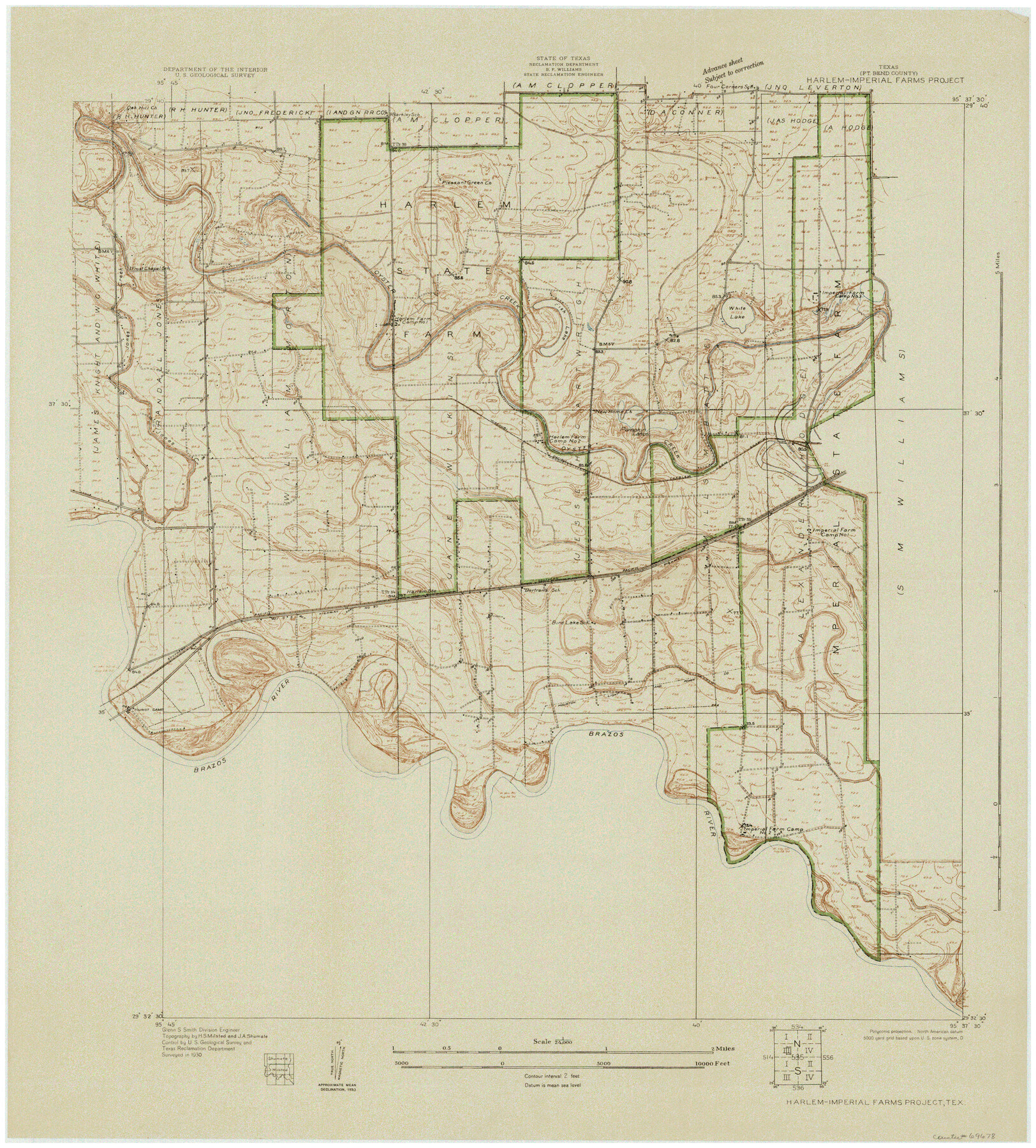
Brazos River, Harlem-Imperial Farms Project
-
Map/Doc
69678
-
Collection
General Map Collection
-
Object Dates
9/1930 (Creation Date)
-
People and Organizations
Texas State Reclamation Department (Publisher)
Glenn S. Smith (Surveyor/Engineer)
H.S. Milsted (Surveyor/Engineer)
J.A. Shumate (Surveyor/Engineer)
-
Counties
Fort Bend
-
Subjects
Prison Farms River Surveys Topographic
-
Height x Width
28.3 x 25.5 inches
71.9 x 64.8 cm
Part of: General Map Collection
Flight Mission No. DQO-11K, Frame 16, Galveston County

Print $20.00
- Digital $50.00
Flight Mission No. DQO-11K, Frame 16, Galveston County
1952
Size 18.8 x 22.5 inches
Map/Doc 85209
Upshur County Working Sketch 4

Print $20.00
- Digital $50.00
Upshur County Working Sketch 4
1939
Size 21.6 x 15.3 inches
Map/Doc 69560

Illinois, Missouri, Iowa, Wisconsin and Minnesota

Print $20.00
- Digital $50.00
Illinois, Missouri, Iowa, Wisconsin and Minnesota
1885
Size 12.2 x 9.0 inches
Map/Doc 93521
Ellis County Sketch File 4

Print $4.00
- Digital $50.00
Ellis County Sketch File 4
1859
Size 13.0 x 8.5 inches
Map/Doc 21832
Gray County Boundary File 11

Print $80.00
- Digital $50.00
Gray County Boundary File 11
Size 20.7 x 19.7 inches
Map/Doc 53912
Uvalde County Sketch File 23A

Print $20.00
- Digital $50.00
Uvalde County Sketch File 23A
1923
Size 18.4 x 23.0 inches
Map/Doc 12535
Flight Mission No. BRA-16M, Frame 86, Jefferson County

Print $20.00
- Digital $50.00
Flight Mission No. BRA-16M, Frame 86, Jefferson County
1953
Size 18.5 x 22.3 inches
Map/Doc 85698
Bailey County Sketch File 10

Print $4.00
- Digital $50.00
Bailey County Sketch File 10
Size 14.1 x 8.7 inches
Map/Doc 13965
[Map Showing Panhandle Counties in Texas]
![2087, [Map Showing Panhandle Counties in Texas], General Map Collection](https://historictexasmaps.com/wmedia_w700/maps/2087.tif.jpg)
Print $20.00
- Digital $50.00
[Map Showing Panhandle Counties in Texas]
1876
Size 27.3 x 27.9 inches
Map/Doc 2087
Castro County Sketch File 3

Print $4.00
- Digital $50.00
Castro County Sketch File 3
1902
Size 11.2 x 8.9 inches
Map/Doc 17458
McMullen County Working Sketch 20

Print $20.00
- Digital $50.00
McMullen County Working Sketch 20
1945
Size 34.1 x 29.6 inches
Map/Doc 70721
You may also like
Flight Mission No. DAG-21K, Frame 101, Matagorda County

Print $20.00
- Digital $50.00
Flight Mission No. DAG-21K, Frame 101, Matagorda County
1952
Size 18.6 x 22.4 inches
Map/Doc 86430
Map of Hidalgo County

Print $20.00
- Digital $50.00
Map of Hidalgo County
1896
Size 44.7 x 26.7 inches
Map/Doc 4978
Saline Ranch in Mason, Kimble and Menard Counties

Print $20.00
- Digital $50.00
Saline Ranch in Mason, Kimble and Menard Counties
1916
Size 28.2 x 27.1 inches
Map/Doc 75807
Map of Bastrop County

Print $20.00
- Digital $50.00
Map of Bastrop County
1861
Size 26.3 x 29.0 inches
Map/Doc 3280
Guadalupe County Sketch File 7

Print $20.00
- Digital $50.00
Guadalupe County Sketch File 7
Size 15.6 x 19.5 inches
Map/Doc 11590
Flight Mission No. DIX-10P, Frame 62, Aransas County

Print $20.00
- Digital $50.00
Flight Mission No. DIX-10P, Frame 62, Aransas County
1956
Size 18.8 x 22.4 inches
Map/Doc 83923
Map of Parts of Dawson and Borden Counties

Print $20.00
- Digital $50.00
Map of Parts of Dawson and Borden Counties
Size 23.0 x 17.7 inches
Map/Doc 90627
Crane County Rolled Sketch 17

Print $20.00
- Digital $50.00
Crane County Rolled Sketch 17
1926
Size 20.3 x 33.8 inches
Map/Doc 5576
Nueces County Rolled Sketch 122

Print $47.00
Nueces County Rolled Sketch 122
1996
Size 24.6 x 40.2 inches
Map/Doc 7153
![90608, [Block K11], Twichell Survey Records](https://historictexasmaps.com/wmedia_w700/maps/90608-1.tif.jpg)
Swisher County Sketch File 8

Print $20.00
- Digital $50.00
Swisher County Sketch File 8
1907
Size 19.2 x 16.3 inches
Map/Doc 12405
