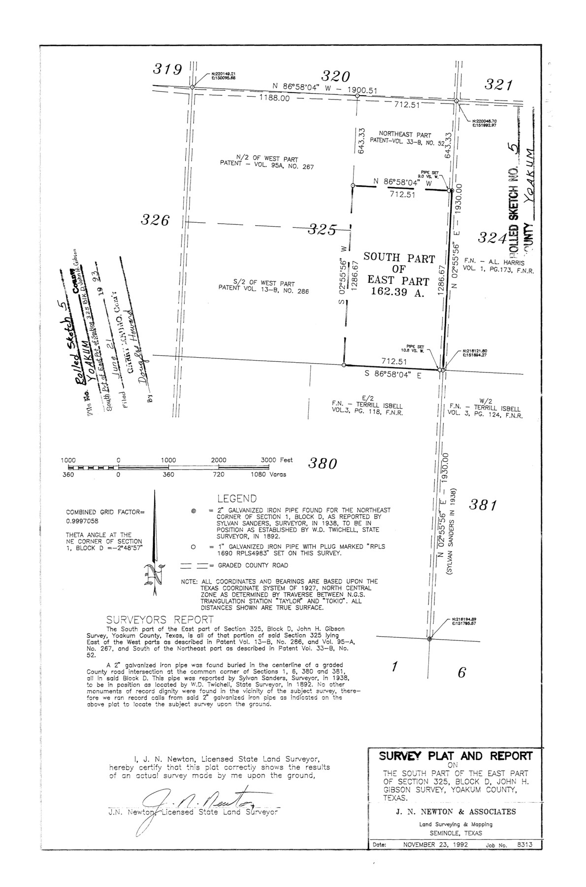
Yoakum County Rolled Sketch 5
Survey plat and report on the south part of the east part of section 325, Block D, John H. Gibson survey, Yoakum County, Texas
-
Map/Doc
8290
-
Collection
General Map Collection
-
Object Dates
1992/11/23 (Creation Date)
1993/6/21 (File Date)
-
People and Organizations
J.N. Newton (Surveyor/Engineer)
-
Counties
Yoakum
-
Subjects
Surveying Rolled Sketch
-
Height x Width
20.9 x 16.3 inches
53.1 x 41.4 cm
-
Medium
mylar, print
Part of: General Map Collection
Kinney County Working Sketch 12

Print $20.00
- Digital $50.00
Kinney County Working Sketch 12
1941
Size 26.7 x 32.1 inches
Map/Doc 70194
Bastrop County Working Sketch 6

Print $20.00
- Digital $50.00
Bastrop County Working Sketch 6
1923
Size 37.5 x 31.2 inches
Map/Doc 67306
Terrell County Working Sketch 84b

Print $20.00
- Digital $50.00
Terrell County Working Sketch 84b
1992
Size 25.2 x 42.7 inches
Map/Doc 69606
Uvalde County Sketch File 12A

Print $20.00
- Digital $50.00
Uvalde County Sketch File 12A
1887
Size 19.2 x 30.0 inches
Map/Doc 12527
Atascosa County Working Sketch 35

Print $20.00
- Digital $50.00
Atascosa County Working Sketch 35
1992
Size 34.6 x 48.1 inches
Map/Doc 67231
Runnels County Working Sketch 34

Print $20.00
- Digital $50.00
Runnels County Working Sketch 34
1974
Size 14.0 x 14.9 inches
Map/Doc 63632
Crockett County Sketch File 59

Print $8.00
- Digital $50.00
Crockett County Sketch File 59
1924
Size 14.1 x 8.8 inches
Map/Doc 19833
Dimmit County Sketch File 17

Print $15.00
- Digital $50.00
Dimmit County Sketch File 17
1886
Size 11.0 x 13.7 inches
Map/Doc 21081
Flight Mission No. DQO-8K, Frame 134, Galveston County

Print $20.00
- Digital $50.00
Flight Mission No. DQO-8K, Frame 134, Galveston County
1952
Size 18.7 x 22.3 inches
Map/Doc 85199

Starr County Sketch File 43

Print $28.00
- Digital $50.00
Starr County Sketch File 43
1941
Size 14.7 x 9.1 inches
Map/Doc 36991
Culberson County Sketch File 45

Print $6.00
- Digital $50.00
Culberson County Sketch File 45
2002
Size 14.2 x 8.8 inches
Map/Doc 76367
You may also like
Hutchinson County Rolled Sketch 44-16

Print $20.00
- Digital $50.00
Hutchinson County Rolled Sketch 44-16
2002
Size 24.0 x 36.0 inches
Map/Doc 77552
Kleberg County Rolled Sketch 7

Print $20.00
- Digital $50.00
Kleberg County Rolled Sketch 7
1947
Size 28.5 x 41.4 inches
Map/Doc 6550
Copy of Surveyor's Field Book, Morris Browning - In Blocks 7, 5 & 4, I&GNRRCo., Hutchinson and Carson Counties, Texas

Print $2.00
- Digital $50.00
Copy of Surveyor's Field Book, Morris Browning - In Blocks 7, 5 & 4, I&GNRRCo., Hutchinson and Carson Counties, Texas
1888
Size 6.9 x 8.8 inches
Map/Doc 62282
Webb County Working Sketch 38

Print $20.00
- Digital $50.00
Webb County Working Sketch 38
1941
Size 20.0 x 17.8 inches
Map/Doc 72403
Rusk County Working Sketch 29b

Print $20.00
- Digital $50.00
Rusk County Working Sketch 29b
Size 25.8 x 18.1 inches
Map/Doc 63666
Crosby County Sketch File 18

Print $26.00
- Digital $50.00
Crosby County Sketch File 18
1905
Size 14.2 x 8.5 inches
Map/Doc 20071
Kerr County Sketch File 9

Print $8.00
- Digital $50.00
Kerr County Sketch File 9
1884
Size 10.2 x 8.2 inches
Map/Doc 28873
Flight Mission No. BRA-7M, Frame 24, Jefferson County

Print $20.00
- Digital $50.00
Flight Mission No. BRA-7M, Frame 24, Jefferson County
1953
Size 18.6 x 22.3 inches
Map/Doc 85475
Intracoastal Waterway in Texas - Corpus Christi to Point Isabel including Arroyo Colorado to Mo. Pac. R.R. Bridge Near Harlingen

Print $20.00
- Digital $50.00
Intracoastal Waterway in Texas - Corpus Christi to Point Isabel including Arroyo Colorado to Mo. Pac. R.R. Bridge Near Harlingen
1933
Size 28.1 x 40.8 inches
Map/Doc 61876
Hopkins County Sketch File 13

Print $4.00
- Digital $50.00
Hopkins County Sketch File 13
1858
Size 12.7 x 8.2 inches
Map/Doc 26709

