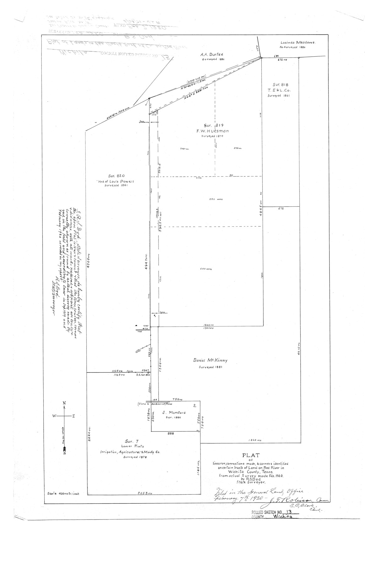
Wichita County Rolled Sketch 13
Plat of lines run, connections made, & corners identified on certain tracts of land on Red River in Wichita County, Texas
-
Map/Doc
8250
-
Collection
General Map Collection
-
Object Dates
1920 (Survey Date)
1920/2/7 (File Date)
-
People and Organizations
R.S. Dod (Surveyor/Engineer)
-
Counties
Wichita
-
Subjects
Surveying Rolled Sketch
-
Height x Width
25.7 x 16.6 inches
65.3 x 42.2 cm
-
Scale
1" = 400 varas
Related maps
Wichita County Sketch File R

Print $8.00
- Digital $50.00
Wichita County Sketch File R
Size 14.3 x 8.8 inches
Map/Doc 40142
Part of: General Map Collection
Webb County Working Sketch 85

Print $20.00
- Digital $50.00
Webb County Working Sketch 85
1981
Size 21.1 x 29.0 inches
Map/Doc 72452
Ward County Rolled Sketch 17

Print $20.00
- Digital $50.00
Ward County Rolled Sketch 17
1947
Size 16.2 x 19.5 inches
Map/Doc 8160
Culberson County Working Sketch 45

Print $20.00
- Digital $50.00
Culberson County Working Sketch 45
1971
Size 24.4 x 37.1 inches
Map/Doc 68499
Sutton County Working Sketch 46

Print $40.00
- Digital $50.00
Sutton County Working Sketch 46
1953
Size 48.4 x 27.1 inches
Map/Doc 62389
Crockett County Working Sketch 100

Print $20.00
- Digital $50.00
Crockett County Working Sketch 100
1980
Size 35.6 x 39.9 inches
Map/Doc 68433
Right of Way and Track Map, the Missouri, Kansas and Texas Ry. of Texas operated by the Missouri, Kansas and Texas Ry. of Texas, San Antonio Division

Print $40.00
- Digital $50.00
Right of Way and Track Map, the Missouri, Kansas and Texas Ry. of Texas operated by the Missouri, Kansas and Texas Ry. of Texas, San Antonio Division
1918
Size 25.4 x 59.2 inches
Map/Doc 64580
Hill County Sketch File 4 1/2

Print $4.00
- Digital $50.00
Hill County Sketch File 4 1/2
1859
Size 8.8 x 8.1 inches
Map/Doc 26468
Angelina County Sketch File 15f

Print $4.00
- Digital $50.00
Angelina County Sketch File 15f
Size 10.4 x 7.6 inches
Map/Doc 12994
Callahan County Rolled Sketch 4

Print $20.00
- Digital $50.00
Callahan County Rolled Sketch 4
1952
Size 20.8 x 30.6 inches
Map/Doc 5381
Gregg County Rolled Sketch 23

Print $40.00
- Digital $50.00
Gregg County Rolled Sketch 23
Size 52.9 x 43.3 inches
Map/Doc 9074
Map of Runnels County

Print $20.00
- Digital $50.00
Map of Runnels County
1879
Size 25.9 x 18.5 inches
Map/Doc 4620
Gonzales County Boundary File 34 (9)

Print $18.00
- Digital $50.00
Gonzales County Boundary File 34 (9)
Size 8.5 x 3.9 inches
Map/Doc 53836
You may also like
Medina County Working Sketch 21

Print $20.00
- Digital $50.00
Medina County Working Sketch 21
1982
Size 18.1 x 23.3 inches
Map/Doc 70936
Tarrant County Working Sketch 23

Print $20.00
- Digital $50.00
Tarrant County Working Sketch 23
2001
Size 15.9 x 15.6 inches
Map/Doc 62440
Panola County Sketch File 22

Print $40.00
- Digital $50.00
Panola County Sketch File 22
Size 15.1 x 16.0 inches
Map/Doc 33492
Trinity River, Big Creek Sheet

Print $40.00
- Digital $50.00
Trinity River, Big Creek Sheet
1924
Size 48.0 x 36.4 inches
Map/Doc 65179
Webb County Sketch File B2

Print $4.00
- Digital $50.00
Webb County Sketch File B2
1909
Size 13.9 x 8.1 inches
Map/Doc 39656
Presidio County Sketch File 92

Print $10.00
- Digital $50.00
Presidio County Sketch File 92
1958
Size 11.2 x 8.8 inches
Map/Doc 34765
[PSL Block A-12]
![93229, [PSL Block A-12], Twichell Survey Records](https://historictexasmaps.com/wmedia_w700/maps/93229-1.tif.jpg)
Print $2.00
- Digital $50.00
[PSL Block A-12]
1953
Size 8.7 x 13.5 inches
Map/Doc 93229
[T. & P. Block 44, Township 1S]
![90893, [T. & P. Block 44, Township 1S], Twichell Survey Records](https://historictexasmaps.com/wmedia_w700/maps/90893-1.tif.jpg)
Print $20.00
- Digital $50.00
[T. & P. Block 44, Township 1S]
Size 21.5 x 10.1 inches
Map/Doc 90893
Galveston County Rolled Sketch 43B

Print $20.00
- Digital $50.00
Galveston County Rolled Sketch 43B
Size 27.3 x 16.2 inches
Map/Doc 76006
Comanche County

Print $20.00
- Digital $50.00
Comanche County
1896
Size 42.2 x 47.6 inches
Map/Doc 66784
Brewster County Rolled Sketch 101

Print $40.00
- Digital $50.00
Brewster County Rolled Sketch 101
1927
Size 74.2 x 42.3 inches
Map/Doc 9192
Flight Mission No. DQO-8K, Frame 135, Galveston County

Print $20.00
- Digital $50.00
Flight Mission No. DQO-8K, Frame 135, Galveston County
1952
Size 18.7 x 22.5 inches
Map/Doc 85200