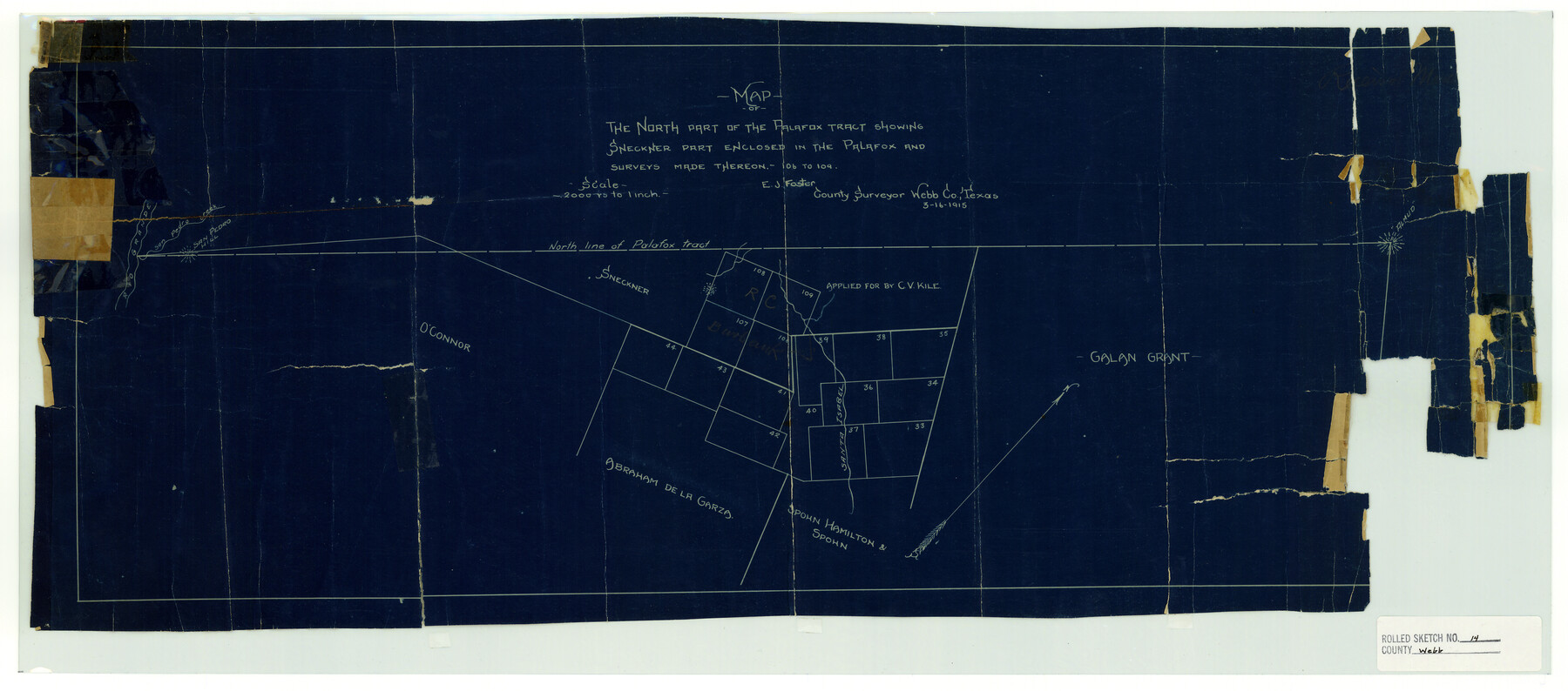
Webb County Rolled Sketch 14
Map of the north part of the Palafox tract showing Sneckner part enclosed in the Palafox and surveys made thereon - 106 to 109
-
Map/Doc
8178
-
Collection
General Map Collection
-
Object Dates
1915/3/22 (File Date)
1915/3/16 (Creation Date)
-
People and Organizations
E.J. Foster (Surveyor/Engineer)
-
Counties
Webb
-
Subjects
Surveying Rolled Sketch
-
Height x Width
12.6 x 28.5 inches
32.0 x 72.4 cm
-
Medium
blueprint/diazo
-
Scale
1" = 2000 varas
Part of: General Map Collection
Flight Mission No. BRA-16M, Frame 132, Jefferson County

Print $20.00
- Digital $50.00
Flight Mission No. BRA-16M, Frame 132, Jefferson County
1953
Size 18.6 x 22.3 inches
Map/Doc 85742
Edwards County Sketch File 17

Print $20.00
- Digital $50.00
Edwards County Sketch File 17
Size 31.8 x 18.3 inches
Map/Doc 11429
San Jacinto County Working Sketch 11

Print $20.00
- Digital $50.00
San Jacinto County Working Sketch 11
1935
Size 40.1 x 40.0 inches
Map/Doc 63724
Madison County Working Sketch 14

Print $20.00
- Digital $50.00
Madison County Working Sketch 14
Size 24.9 x 17.0 inches
Map/Doc 78204
Andrews County Boundary File 1

Print $133.00
- Digital $50.00
Andrews County Boundary File 1
Size 14.6 x 9.0 inches
Map/Doc 49664
Nueces County Sketch File 54

Print $4.00
- Digital $50.00
Nueces County Sketch File 54
1856
Size 12.7 x 8.1 inches
Map/Doc 32865
Camp County Working Sketch 3

Print $20.00
- Digital $50.00
Camp County Working Sketch 3
1982
Size 32.1 x 24.4 inches
Map/Doc 67879
Andrews County Rolled Sketch 22

Print $20.00
- Digital $50.00
Andrews County Rolled Sketch 22
1946
Size 26.4 x 24.0 inches
Map/Doc 77170
Karnes County Rolled Sketch 2

Print $20.00
- Digital $50.00
Karnes County Rolled Sketch 2
1957
Size 35.3 x 30.0 inches
Map/Doc 6453
Intracoastal Waterway in Texas - Corpus Christi to Point Isabel including Arroyo Colorado to Mo. Pac. R.R. Bridge Near Harlingen

Print $20.00
- Digital $50.00
Intracoastal Waterway in Texas - Corpus Christi to Point Isabel including Arroyo Colorado to Mo. Pac. R.R. Bridge Near Harlingen
1933
Size 40.6 x 28.0 inches
Map/Doc 61877
Hall County Sketch File 12

Print $20.00
- Digital $50.00
Hall County Sketch File 12
Size 31.9 x 35.5 inches
Map/Doc 10474
Flight Mission No. BRE-2P, Frame 7, Nueces County

Print $20.00
- Digital $50.00
Flight Mission No. BRE-2P, Frame 7, Nueces County
1956
Size 18.5 x 22.4 inches
Map/Doc 86716
You may also like
Houston County Rolled Sketch 8

Print $20.00
- Digital $50.00
Houston County Rolled Sketch 8
1948
Size 27.7 x 20.3 inches
Map/Doc 6228
General Highway Map, Dimmit County, Zavala County, Texas

Print $20.00
General Highway Map, Dimmit County, Zavala County, Texas
1961
Size 18.2 x 24.6 inches
Map/Doc 79444
Map of Upshur County

Print $20.00
- Digital $50.00
Map of Upshur County
Size 18.5 x 23.2 inches
Map/Doc 76755
Oldham County

Print $40.00
- Digital $50.00
Oldham County
1925
Size 43.6 x 53.5 inches
Map/Doc 66960
Medina County Boundary File 1

Print $14.00
- Digital $50.00
Medina County Boundary File 1
Size 12.8 x 8.1 inches
Map/Doc 57019
Val Verde County Working Sketch 116

Print $20.00
- Digital $50.00
Val Verde County Working Sketch 116
2003
Size 38.4 x 34.8 inches
Map/Doc 78493
Brazos County Working Sketch 4

Print $20.00
- Digital $50.00
Brazos County Working Sketch 4
1976
Size 22.5 x 20.6 inches
Map/Doc 67479
Tom Green County Working Sketch 14

Print $20.00
- Digital $50.00
Tom Green County Working Sketch 14
1982
Size 32.7 x 22.7 inches
Map/Doc 69383
Angelina County Sketch File 20

Print $40.00
- Digital $50.00
Angelina County Sketch File 20
1882
Size 19.7 x 29.4 inches
Map/Doc 10816
General Highway Map, Kleberg County, Texas

Print $20.00
General Highway Map, Kleberg County, Texas
1940
Size 24.9 x 18.4 inches
Map/Doc 79165
Hudspeth County Rolled Sketch 77

Print $20.00
- Digital $50.00
Hudspeth County Rolled Sketch 77
Size 25.2 x 38.0 inches
Map/Doc 6265
Shelby County Sketch File 23

Print $5.00
- Digital $50.00
Shelby County Sketch File 23
Size 16.2 x 7.3 inches
Map/Doc 36645