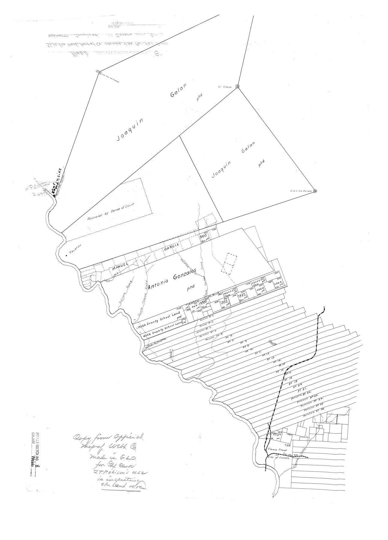
Webb County Rolled Sketch 8
Copy from official map of Webb Co. made in GLO for Chf. Clerk J.T. Robison's use in inspecting the land
-
Map/Doc
8174
-
Collection
General Map Collection
-
Counties
Webb
-
Subjects
Surveying Rolled Sketch
-
Height x Width
26.7 x 19.2 inches
67.8 x 48.8 cm
Part of: General Map Collection
Reagan County Working Sketch 21

Print $20.00
- Digital $50.00
Reagan County Working Sketch 21
1955
Size 23.4 x 19.9 inches
Map/Doc 71863
Brazoria County Sketch File 41

Print $40.00
- Digital $50.00
Brazoria County Sketch File 41
1939
Size 19.5 x 26.6 inches
Map/Doc 10960
Val Verde County Rolled Sketch ECS

Print $20.00
- Digital $50.00
Val Verde County Rolled Sketch ECS
1935
Size 45.6 x 35.6 inches
Map/Doc 10079
San Patricio County Rolled Sketch 38

Print $20.00
- Digital $50.00
San Patricio County Rolled Sketch 38
1950
Size 15.6 x 15.7 inches
Map/Doc 7588
Young County Sketch File 8

Print $20.00
- Digital $50.00
Young County Sketch File 8
1856
Size 19.8 x 17.7 inches
Map/Doc 12710
Sulphur River, Talco Sheet

Print $20.00
- Digital $50.00
Sulphur River, Talco Sheet
1917
Size 12.5 x 25.5 inches
Map/Doc 78336
Jeff Davis County Sketch File 29

Print $30.00
- Digital $50.00
Jeff Davis County Sketch File 29
Size 14.2 x 8.5 inches
Map/Doc 28008
Hutchinson County Rolled Sketch 44-5

Print $20.00
- Digital $50.00
Hutchinson County Rolled Sketch 44-5
2002
Size 24.0 x 36.0 inches
Map/Doc 77541
Presidio County Rolled Sketch 68

Print $20.00
- Digital $50.00
Presidio County Rolled Sketch 68
1927
Size 11.8 x 24.4 inches
Map/Doc 7358
La Salle County Sketch File 19

Print $32.00
- Digital $50.00
La Salle County Sketch File 19
1885
Size 14.2 x 8.7 inches
Map/Doc 29509
Hudspeth County Working Sketch 26

Print $40.00
- Digital $50.00
Hudspeth County Working Sketch 26
1972
Size 31.5 x 54.0 inches
Map/Doc 66308
Map of Henderson Co.

Print $40.00
- Digital $50.00
Map of Henderson Co.
1886
Size 27.8 x 57.6 inches
Map/Doc 3663
You may also like
[Part of Blocks 34 and 35, Township 3 North]
![91287, [Part of Blocks 34 and 35, Township 3 North], Twichell Survey Records](https://historictexasmaps.com/wmedia_w700/maps/91287-1.tif.jpg)
Print $20.00
- Digital $50.00
[Part of Blocks 34 and 35, Township 3 North]
Size 12.7 x 13.5 inches
Map/Doc 91287
Westliches - Nordamerica

Print $20.00
- Digital $50.00
Westliches - Nordamerica
1867
Size 25.3 x 20.7 inches
Map/Doc 93753
Jefferson County Rolled Sketch 12

Print $2.00
- Digital $50.00
Jefferson County Rolled Sketch 12
Size 10.6 x 8.2 inches
Map/Doc 76004
Waller County Working Sketch 2

Print $20.00
- Digital $50.00
Waller County Working Sketch 2
1955
Size 19.5 x 18.8 inches
Map/Doc 72301
[Galveston, Harrisburg & San Antonio from El Paso-Presidio county boundary to Presidio-Pecos county boundary]
![64717, [Galveston, Harrisburg & San Antonio from El Paso-Presidio county boundary to Presidio-Pecos county boundary], General Map Collection](https://historictexasmaps.com/wmedia_w700/maps/64717.tif.jpg)
Print $40.00
- Digital $50.00
[Galveston, Harrisburg & San Antonio from El Paso-Presidio county boundary to Presidio-Pecos county boundary]
Size 149.3 x 44.4 inches
Map/Doc 64717
Gulf Oil Corp. Fishgide - Port O'Connor

Gulf Oil Corp. Fishgide - Port O'Connor
1960
Size 12.0 x 22.0 inches
Map/Doc 75982

[Capitol Lands, Block B6]
![91402, [Capitol Lands, Block B6], Twichell Survey Records](https://historictexasmaps.com/wmedia_w700/maps/91402-1.tif.jpg)
Print $20.00
- Digital $50.00
[Capitol Lands, Block B6]
Size 22.7 x 27.4 inches
Map/Doc 91402
Shelby County Working Sketch 6

Print $20.00
- Digital $50.00
Shelby County Working Sketch 6
1941
Size 25.1 x 18.9 inches
Map/Doc 63859
Flight Mission No. DAG-23K, Frame 143, Matagorda County

Print $20.00
- Digital $50.00
Flight Mission No. DAG-23K, Frame 143, Matagorda County
1953
Size 15.8 x 15.7 inches
Map/Doc 86491
Smith County Working Sketch 5

Print $20.00
- Digital $50.00
Smith County Working Sketch 5
1932
Size 32.2 x 22.4 inches
Map/Doc 63890
Real County Working Sketch 75

Print $20.00
- Digital $50.00
Real County Working Sketch 75
1979
Size 29.0 x 28.6 inches
Map/Doc 71967