![81, [Surveys in Power and Hewetson's Colony along the Aransas River, Middle Creek, Papalose Creek, and Blanco Creek], General Map Collection](https://historictexasmaps.com/wmedia_w1800h1800/maps/81.tif.jpg)
[Surveys in Power and Hewetson's Colony along the Aransas River, Middle Creek, Papalose Creek, and Blanco Creek]
Atlas B, Sketch 11 (B-11)
B-11
-
Map/Doc
81
-
Collection
General Map Collection
-
Object Dates
1830 (Creation Date)
-
People and Organizations
General Land Office (Publisher)
Fred W. (Draftsman)
-
Counties
Goliad Refugio Bee
-
Subjects
Atlas
-
Height x Width
21.6 x 21.2 inches
54.9 x 53.8 cm
-
Medium
paper, manuscript
-
Comments
Conserved in 2004.
-
Features
Road from Goliad to San Patricio
Goliad Road
San Patricio Road
Road from Refugio to San Patricio
Refugio Road
Aransas River
La Yesca Creek
La Bata Creek
Papelote Creek
Mugereno Creek
Blanco Creek
Middle Creek
Paus Creek
Chocolate Creek
Melon Creek
Part of: General Map Collection
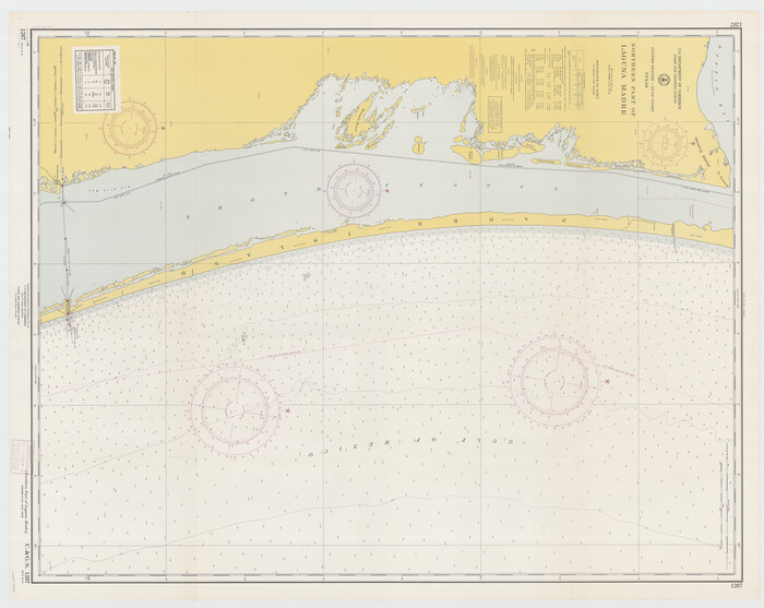
Northern Part of Laguna Madre
Print $20.00
- Digital $50.00
Northern Part of Laguna Madre
1965
Size 43.9 x 34.6 inches
Map/Doc 73527
Houston County Sketch File 14

Print $6.00
- Digital $50.00
Houston County Sketch File 14
1886
Size 8.8 x 13.0 inches
Map/Doc 26778
Moore County Working Sketch 6

Print $20.00
- Digital $50.00
Moore County Working Sketch 6
1921
Size 16.0 x 14.5 inches
Map/Doc 71188
Webb County Working Sketch 25

Print $20.00
- Digital $50.00
Webb County Working Sketch 25
1928
Size 38.8 x 31.2 inches
Map/Doc 72390
Ward County Working Sketch 18

Print $20.00
- Digital $50.00
Ward County Working Sketch 18
1949
Size 20.3 x 21.9 inches
Map/Doc 72324
Lavaca County Sketch File 20

Print $8.00
- Digital $50.00
Lavaca County Sketch File 20
Size 10.0 x 8.0 inches
Map/Doc 29650
Map of the City of Austin

Print $20.00
- Digital $50.00
Map of the City of Austin
1876
Size 36.5 x 30.4 inches
Map/Doc 78477
Harris County Working Sketch 54

Print $20.00
- Digital $50.00
Harris County Working Sketch 54
1950
Size 21.3 x 24.1 inches
Map/Doc 65946
Layout of the porciones as described in the Visita General of Camargo, 1767

Layout of the porciones as described in the Visita General of Camargo, 1767
2009
Size 11.0 x 8.5 inches
Map/Doc 94041
Map of Henderson County

Print $40.00
- Digital $50.00
Map of Henderson County
1897
Size 28.9 x 58.9 inches
Map/Doc 66860

Crosby County Sketch File 14a

Print $40.00
- Digital $50.00
Crosby County Sketch File 14a
Size 18.9 x 20.5 inches
Map/Doc 11249
You may also like
Map of Rotan Fisher County, Texas

Print $20.00
- Digital $50.00
Map of Rotan Fisher County, Texas
1926
Size 32.2 x 36.5 inches
Map/Doc 93231
[Blocks 5-T, R-2, M-24, and M-23]
![91149, [Blocks 5-T, R-2, M-24, and M-23], Twichell Survey Records](https://historictexasmaps.com/wmedia_w700/maps/91149-1.tif.jpg)
Print $20.00
- Digital $50.00
[Blocks 5-T, R-2, M-24, and M-23]
Size 15.5 x 19.7 inches
Map/Doc 91149
Hudspeth County Rolled Sketch 55

Print $49.00
- Digital $50.00
Hudspeth County Rolled Sketch 55
1977
Size 10.0 x 15.0 inches
Map/Doc 45968
South Montgomery County, Woodlands Chamber of Commerce Street Map

South Montgomery County, Woodlands Chamber of Commerce Street Map
Size 50.0 x 37.9 inches
Map/Doc 94363
Map of Chicago, Rock Island & Texas Railway through Wise and Tarrant County, Texas

Print $20.00
- Digital $50.00
Map of Chicago, Rock Island & Texas Railway through Wise and Tarrant County, Texas
1893
Size 19.6 x 43.7 inches
Map/Doc 64429
Flight Mission No. BRA-16M, Frame 96, Jefferson County

Print $20.00
- Digital $50.00
Flight Mission No. BRA-16M, Frame 96, Jefferson County
1953
Size 18.6 x 22.4 inches
Map/Doc 85708
Brewster County Rolled Sketch 50
Print $20.00
- Digital $50.00
Brewster County Rolled Sketch 50
1932
Size 21.0 x 26.6 inches
Map/Doc 5226
Grayson County Sketch File 13

Print $40.00
- Digital $50.00
Grayson County Sketch File 13
1853
Size 16.2 x 14.4 inches
Map/Doc 24480
Map of surveys 189 & 190, T. C. R.R. Co. in Travis County, Texas

Print $20.00
- Digital $50.00
Map of surveys 189 & 190, T. C. R.R. Co. in Travis County, Texas
1915
Size 16.3 x 23.5 inches
Map/Doc 75762

[Blocks 36, 37 Township 2 South]
![92320, [Blocks 36, 37 Township 2 South], Twichell Survey Records](https://historictexasmaps.com/wmedia_w700/maps/92320-1.tif.jpg)
Print $20.00
- Digital $50.00
[Blocks 36, 37 Township 2 South]
Size 24.6 x 18.9 inches
Map/Doc 92320
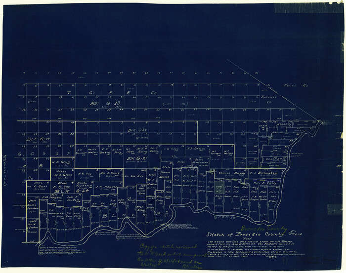
Presidio County Rolled Sketch 131A

Print $20.00
- Digital $50.00
Presidio County Rolled Sketch 131A
Size 17.7 x 11.9 inches
Map/Doc 10710