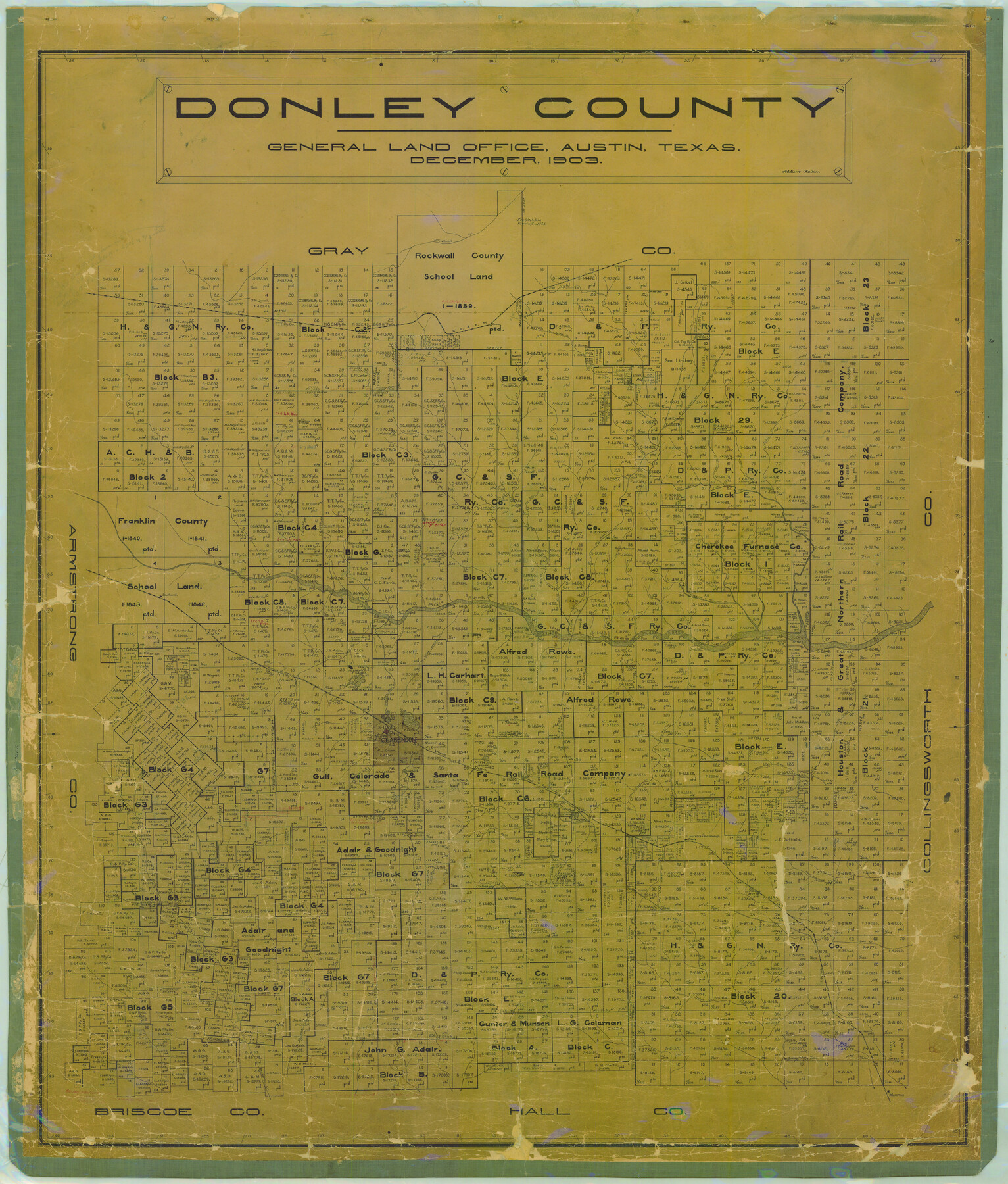
Donley County
-
Map/Doc
4724
-
Collection
General Map Collection
-
Object Dates
1903 (Creation Date)
-
People and Organizations
Texas General Land Office (Publisher)
Addison Walker (Draftsman)
Addison Walker (Compiler)
-
Counties
Donley
-
Subjects
County
-
Height x Width
47.1 x 39.9 inches
119.6 x 101.3 cm
-
Comments
Conservation funded in 2008 by Friends of the Texas General Land Office.
-
Features
Brown Lake
Big Sandy Creek
Hall Creek
Buck Creek
Rowe
Warley Lake
Kilfoil Draw
Palodura Road
Green Lake
Clarendon
Hall County Road
Indian Creek
Crow Hollow Creek
Lake Creek
Oklahoma Draw
Southard
Jesse Arroyo
Sand Hollow Creek
Main Creek
Eagle Hollow Creek
Little Brushy Creek
Cow Creek
Collingsworth County Road
Red Creek
McClelland Peak
Sandy Creek
Goodnight
Warley Lake
Clara Lake
Gray County Road
Pandle City Road
Spring Creek
Lake Clarendon
Red Hot Creek
Parks Creek
North Prong of Buck Creek
Leola Lake
Charley Lake
Clarendon and Mobeetie Road
Lelia
Mulberry Creek
Memphis
FW&D
Little Wind Cañon Creek
Glenwood Creek
Hay Hollow Creek
Barton Creek
Carroll Creek
Spring Creek
Lost Creek
Saddlers Creek
Petrified Canon Creek
Willow Springs
Conglomerate Creek
Skillet Creek
White Fish Creek
Rath's Trail
Parks Creek
Rock Springs Creek
Rock Springs
Evans
CO&G
Jericho
Chalk Hollow Creek
Gray County Road
Dubbs Lake
Kelly Creek
Armstrong County Road
Old Clarendon
Turkey Creek
Salt Fork of Red River
Calf Creek
Old Rath Trail
Horse Creek
McClellands Creek
Troublesome Creek
Red Mud Creek
Lampton Creek
McCormick Creek
Red Hot Creek
Camp Springs
Camp Creek
Quail Creek
Walnut Creek
Part of: General Map Collection
West End of Copano Bay and Town of Saint Marys, Texas

Print $40.00
- Digital $50.00
West End of Copano Bay and Town of Saint Marys, Texas
1861
Size 54.5 x 32.9 inches
Map/Doc 73428
Matagorda Light to Aransas Pass

Print $20.00
- Digital $50.00
Matagorda Light to Aransas Pass
1946
Size 35.8 x 44.5 inches
Map/Doc 73394
Sutton County Rolled Sketch 45

Print $20.00
- Digital $50.00
Sutton County Rolled Sketch 45
Size 39.1 x 47.2 inches
Map/Doc 9974
Henderson County Sketch File 10

Print $4.00
- Digital $50.00
Henderson County Sketch File 10
1859
Size 12.8 x 8.3 inches
Map/Doc 26346
El Paso County Working Sketch 36

Print $20.00
- Digital $50.00
El Paso County Working Sketch 36
1983
Size 34.0 x 40.3 inches
Map/Doc 69058
Lipscomb County Boundary File 3

Print $4.00
- Digital $50.00
Lipscomb County Boundary File 3
Size 8.2 x 6.5 inches
Map/Doc 56318
Childress County Boundary File 1

Print $2.00
- Digital $50.00
Childress County Boundary File 1
Size 8.9 x 3.8 inches
Map/Doc 51305
Goliad County Working Sketch 23

Print $20.00
- Digital $50.00
Goliad County Working Sketch 23
1979
Size 26.8 x 32.9 inches
Map/Doc 63213
United States - Gulf Coast - Galveston to Rio Grande

Print $20.00
- Digital $50.00
United States - Gulf Coast - Galveston to Rio Grande
1941
Size 27.0 x 18.2 inches
Map/Doc 72754
Hale County Sketch File 23

Print $4.00
- Digital $50.00
Hale County Sketch File 23
1903
Size 11.2 x 8.5 inches
Map/Doc 24759
[Location, Fort Worth & Denver Railroad, through Wilbarger County]
![64345, [Location, Fort Worth & Denver Railroad, through Wilbarger County], General Map Collection](https://historictexasmaps.com/wmedia_w700/maps/64345.tif.jpg)
Print $40.00
- Digital $50.00
[Location, Fort Worth & Denver Railroad, through Wilbarger County]
Size 20.7 x 92.7 inches
Map/Doc 64345
Camp County Working Sketch 3

Print $20.00
- Digital $50.00
Camp County Working Sketch 3
1982
Size 32.1 x 24.4 inches
Map/Doc 67879
You may also like
Texas 1973 Official Highway Travel Map

Texas 1973 Official Highway Travel Map
Size 28.2 x 36.3 inches
Map/Doc 94405
Connected Map of Austin's Colony (1892 tracing)

Print $40.00
- Digital $50.00
Connected Map of Austin's Colony (1892 tracing)
1837
Size 90.8 x 46.7 inches
Map/Doc 93358

Aransas County Sketch File 4

Print $4.00
- Digital $50.00
Aransas County Sketch File 4
1848
Size 10.8 x 8.9 inches
Map/Doc 13106
Orange County Working Sketch 47

Print $20.00
- Digital $50.00
Orange County Working Sketch 47
1987
Size 27.5 x 26.5 inches
Map/Doc 71379
Flight Mission No. DQO-1K, Frame 89, Galveston County

Print $20.00
- Digital $50.00
Flight Mission No. DQO-1K, Frame 89, Galveston County
1952
Size 18.9 x 22.5 inches
Map/Doc 84985
San Augustine County School Land for sale by Lubbock Irrigation Company

Print $20.00
- Digital $50.00
San Augustine County School Land for sale by Lubbock Irrigation Company
Size 23.4 x 24.8 inches
Map/Doc 92826
Jim Hogg County Working Sketch 6

Print $40.00
- Digital $50.00
Jim Hogg County Working Sketch 6
1961
Size 63.3 x 42.8 inches
Map/Doc 66592
Travis County

Print $40.00
- Digital $50.00
Travis County
1936
Size 45.6 x 52.3 inches
Map/Doc 77438
Culberson Co.

Print $40.00
- Digital $50.00
Culberson Co.
1943
Size 53.1 x 33.1 inches
Map/Doc 95473
[Northern boundary line of McMullen's claim]
![313, [Northern boundary line of McMullen's claim], General Map Collection](https://historictexasmaps.com/wmedia_w700/maps/313.tif.jpg)
Print $2.00
- Digital $50.00
[Northern boundary line of McMullen's claim]
1847
Size 13.5 x 8.0 inches
Map/Doc 313
Van Zandt County Sketch File 32

Print $4.00
- Digital $50.00
Van Zandt County Sketch File 32
1860
Size 12.2 x 7.9 inches
Map/Doc 39465