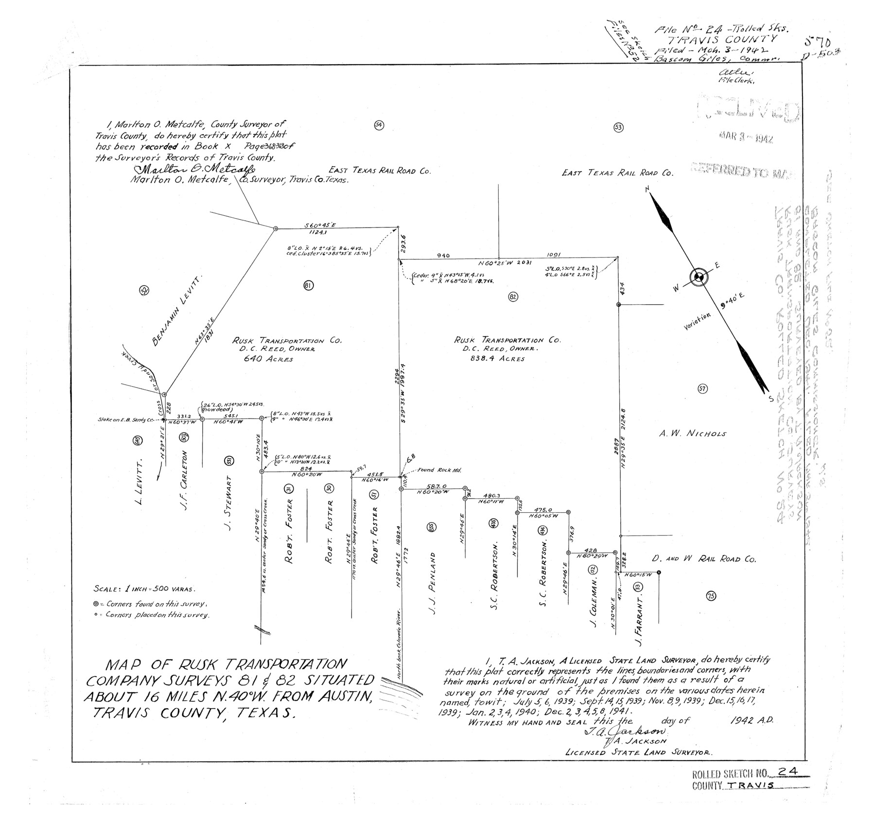
Travis County Rolled Sketch 24
Map of Rusk Transportation Company surveys 81 & 82
-
Map/Doc
8025
-
Collection
General Map Collection
-
Object Dates
1942/3/3 (File Date)
1941/12/8 (Survey Date)
1942 (Creation Date)
-
People and Organizations
T.A. Jackson (Surveyor/Engineer)
-
Counties
Travis
-
Subjects
Surveying Rolled Sketch
-
Height x Width
15.3 x 16.1 inches
38.9 x 40.9 cm
-
Scale
1" = 500 varas
Related maps
Travis County Sketch File 52

Print $8.00
- Digital $50.00
Travis County Sketch File 52
1942
Size 14.4 x 8.9 inches
Map/Doc 38391
Part of: General Map Collection
Navarro County Working Sketch 8

Print $20.00
- Digital $50.00
Navarro County Working Sketch 8
1955
Size 17.9 x 19.2 inches
Map/Doc 71238
Matagorda County Rolled Sketch 35

Print $20.00
- Digital $50.00
Matagorda County Rolled Sketch 35
1903
Size 18.6 x 38.0 inches
Map/Doc 6696
Brewster County Rolled Sketch 105

Print $20.00
- Digital $50.00
Brewster County Rolled Sketch 105
Size 27.2 x 24.5 inches
Map/Doc 5257
Gillespie County Rolled Sketch 8

Print $20.00
- Digital $50.00
Gillespie County Rolled Sketch 8
2008
Size 20.2 x 19.1 inches
Map/Doc 89014
Map of the Fort Worth & Denver City Railway, Hartley County, Texas

Print $40.00
- Digital $50.00
Map of the Fort Worth & Denver City Railway, Hartley County, Texas
1887
Size 21.9 x 89.8 inches
Map/Doc 64390
Reeves County Working Sketch 29

Print $20.00
- Digital $50.00
Reeves County Working Sketch 29
1969
Size 20.1 x 41.5 inches
Map/Doc 63472
Montgomery County Working Sketch 25

Print $40.00
- Digital $50.00
Montgomery County Working Sketch 25
1941
Size 50.0 x 43.7 inches
Map/Doc 71132
Map of 4th Section of 54.68 Miles East from Franklin, Rio Grande Division T. and P. Ry.

Print $40.00
- Digital $50.00
Map of 4th Section of 54.68 Miles East from Franklin, Rio Grande Division T. and P. Ry.
1881
Size 150.0 x 21.9 inches
Map/Doc 64639
Brewster County Rolled Sketch 130

Print $20.00
- Digital $50.00
Brewster County Rolled Sketch 130
1978
Size 18.4 x 24.6 inches
Map/Doc 5302
Nueces County Sketch File 83

Print $63.00
- Digital $50.00
Nueces County Sketch File 83
1997
Size 11.1 x 8.5 inches
Map/Doc 43013
Cottle County Working Sketch 4

Print $20.00
- Digital $50.00
Cottle County Working Sketch 4
1916
Size 34.3 x 31.4 inches
Map/Doc 68314
Flight Mission No. CLL-1N, Frame 18, Willacy County

Print $20.00
- Digital $50.00
Flight Mission No. CLL-1N, Frame 18, Willacy County
1954
Size 18.3 x 22.1 inches
Map/Doc 87005
You may also like
Hudspeth County Working Sketch 31

Print $40.00
- Digital $50.00
Hudspeth County Working Sketch 31
1972
Size 56.2 x 41.2 inches
Map/Doc 66314
[Atlas A, Table of Contents, part 2]
![82085, [Atlas A, Table of Contents, part 2], General Map Collection](https://historictexasmaps.com/wmedia_w700/maps/82085.tif.jpg)
Print $2.00
- Digital $50.00
[Atlas A, Table of Contents, part 2]
Size 7.0 x 11.8 inches
Map/Doc 82085
Garza County Boundary File 3

Print $76.00
- Digital $50.00
Garza County Boundary File 3
Size 11.4 x 9.0 inches
Map/Doc 53683
Reeves County Working Sketch 4

Print $20.00
- Digital $50.00
Reeves County Working Sketch 4
1922
Size 32.5 x 33.1 inches
Map/Doc 63446
Crockett County Rolled Sketch 88A

Print $20.00
- Digital $50.00
Crockett County Rolled Sketch 88A
Size 29.9 x 18.6 inches
Map/Doc 5627
Flight Mission No. DQN-7K, Frame 36, Calhoun County

Print $20.00
- Digital $50.00
Flight Mission No. DQN-7K, Frame 36, Calhoun County
1953
Size 18.5 x 22.2 inches
Map/Doc 84474
Upshur County

Print $20.00
- Digital $50.00
Upshur County
1945
Size 39.8 x 35.8 inches
Map/Doc 73308
Crockett County Sketch File 71

Print $8.00
- Digital $50.00
Crockett County Sketch File 71
1934
Size 11.2 x 8.8 inches
Map/Doc 19858
Irion County Working Sketch 16

Print $20.00
- Digital $50.00
Irion County Working Sketch 16
1973
Size 37.8 x 36.7 inches
Map/Doc 66425

Flight Mission No. DAG-23K, Frame 13, Matagorda County

Print $20.00
- Digital $50.00
Flight Mission No. DAG-23K, Frame 13, Matagorda County
1953
Size 18.5 x 22.2 inches
Map/Doc 86475
Kaufman County Boundary File 2

Print $22.00
- Digital $50.00
Kaufman County Boundary File 2
Size 14.1 x 8.6 inches
Map/Doc 55911