Freestone County State Real Property Sketch 1
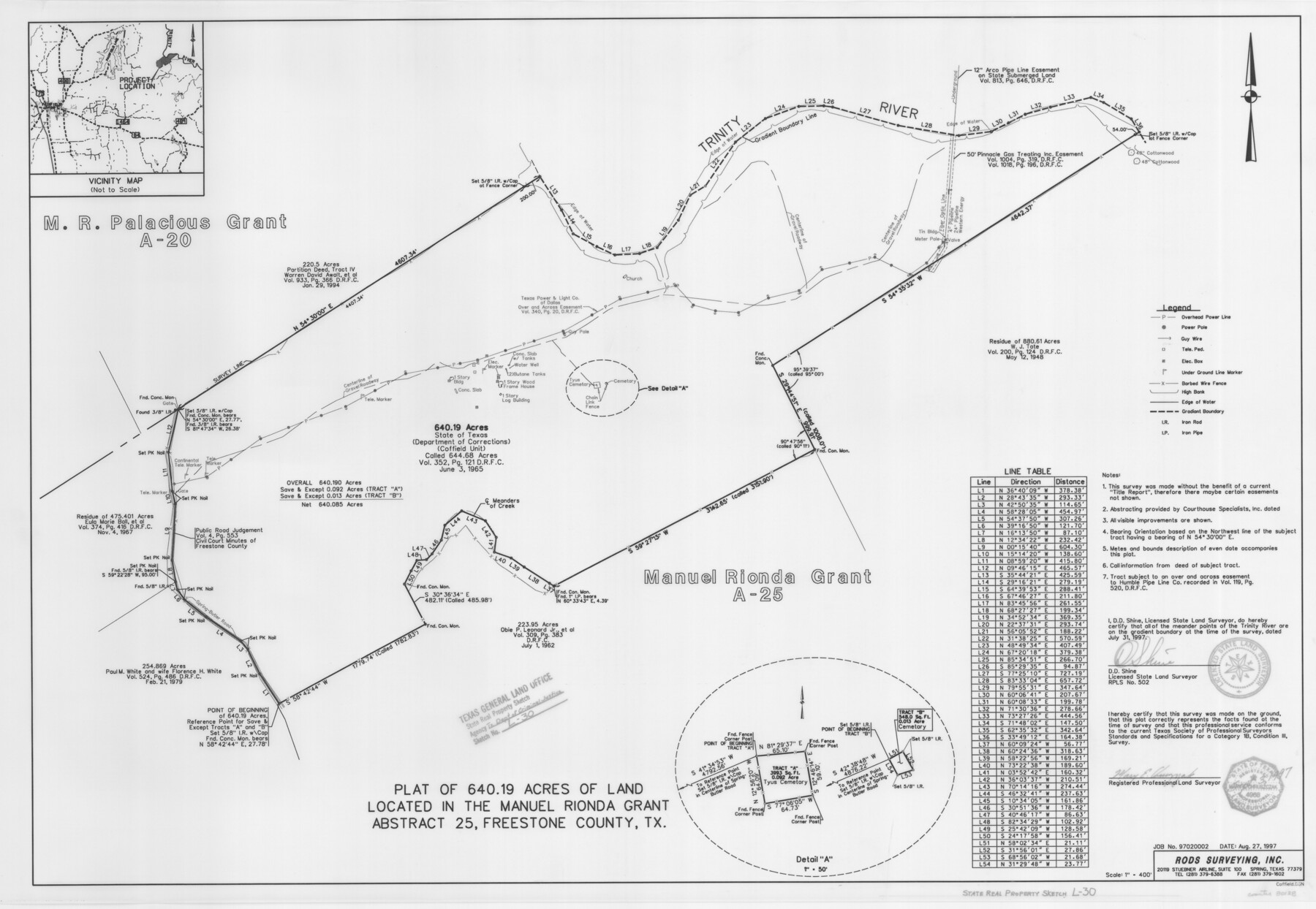
A Plat of 640.19 Acres of Land Located in the Manuel Rionda Grant, A - 25, Coffield Unit
State Real Property Sketch L - 30
-
Map/Doc
80128
-
Collection
General Map Collection
-
Object Dates
1997/8/27 (Creation Date)
-
People and Organizations
Rods Surveying, Inc. (Publisher)
Rods Surveying, Inc. (Printer)
Mary E. Churyzak (Surveyor/Engineer)
D.D. Shine (Surveyor/Engineer)
-
Counties
Freestone
-
Subjects
State Real Property
-
Height x Width
24.3 x 35.2 inches
61.7 x 89.4 cm
-
Comments
Surveys located about 12 miles North 68 degrees East of Fairfield, Texas.
Part of: General Map Collection
Map of Parmer County

Print $20.00
- Digital $50.00
Map of Parmer County
1900
Size 47.8 x 41.3 inches
Map/Doc 16786
Presidio County Working Sketch 29

Print $20.00
- Digital $50.00
Presidio County Working Sketch 29
1946
Size 40.0 x 36.6 inches
Map/Doc 71705
Fannin County

Print $20.00
- Digital $50.00
Fannin County
1946
Size 40.6 x 35.4 inches
Map/Doc 77277
Harris County Working Sketch 16

Print $20.00
- Digital $50.00
Harris County Working Sketch 16
1916
Size 19.8 x 21.2 inches
Map/Doc 65908
Flight Mission No. DAG-24K, Frame 132, Matagorda County

Print $20.00
- Digital $50.00
Flight Mission No. DAG-24K, Frame 132, Matagorda County
1953
Size 15.8 x 15.8 inches
Map/Doc 86550

Kimble County Sketch File 10

Print $23.00
- Digital $50.00
Kimble County Sketch File 10
Size 18.5 x 15.6 inches
Map/Doc 28931
El Paso County Working Sketch 27

Print $6.00
- Digital $50.00
El Paso County Working Sketch 27
1963
Size 34.2 x 13.2 inches
Map/Doc 69049
Karte des Staates, Texas

Print $20.00
- Digital $50.00
Karte des Staates, Texas
1851
Size 25.5 x 30.8 inches
Map/Doc 2123
Smith County Rolled Sketch 6

Print $20.00
- Digital $50.00
Smith County Rolled Sketch 6
1999
Size 43.3 x 30.0 inches
Map/Doc 10699
Crockett County Rolled Sketch 30

Print $20.00
- Digital $50.00
Crockett County Rolled Sketch 30
1934
Size 24.5 x 43.1 inches
Map/Doc 8700
Erath County Working Sketch 14

Print $4.00
- Digital $50.00
Erath County Working Sketch 14
1959
Size 24.7 x 21.9 inches
Map/Doc 69095
You may also like
Dimmit County Sketch File 58

Print $20.00
- Digital $50.00
Dimmit County Sketch File 58
1951
Size 18.0 x 9.8 inches
Map/Doc 11361
Flight Mission No. DCL-7C, Frame 43, Kenedy County

Print $20.00
- Digital $50.00
Flight Mission No. DCL-7C, Frame 43, Kenedy County
1943
Size 15.5 x 15.5 inches
Map/Doc 86031
Lockney, Texas. Layout of Proposed Waterworks Improvements

Print $20.00
- Digital $50.00
Lockney, Texas. Layout of Proposed Waterworks Improvements
1927
Size 30.8 x 23.4 inches
Map/Doc 92643
United States Great Lakes and adjacent waterways

Print $20.00
- Digital $50.00
United States Great Lakes and adjacent waterways
Size 20.8 x 42.7 inches
Map/Doc 76122
Howard County Working Sketch 7b

Print $40.00
- Digital $50.00
Howard County Working Sketch 7b
1950
Size 83.3 x 25.6 inches
Map/Doc 66274
Hunt County Boundary File 4

Print $16.00
- Digital $50.00
Hunt County Boundary File 4
Size 14.3 x 8.6 inches
Map/Doc 55214
Map of Hidalgo County

Print $20.00
- Digital $50.00
Map of Hidalgo County
1896
Size 44.7 x 26.7 inches
Map/Doc 4978
Calhoun County Rolled Sketch 26

Print $20.00
- Digital $50.00
Calhoun County Rolled Sketch 26
1941
Size 10.9 x 39.9 inches
Map/Doc 5374
DeWitt County Working Sketch 16

Print $20.00
- Digital $50.00
DeWitt County Working Sketch 16
1920
Size 23.0 x 25.1 inches
Map/Doc 69016
Jefferson County Sketch File 50

Print $5.00
- Digital $50.00
Jefferson County Sketch File 50
1841
Size 8.2 x 9.7 inches
Map/Doc 28247
Hudspeth County Rolled Sketch 26

Print $20.00
- Digital $50.00
Hudspeth County Rolled Sketch 26
1909
Size 19.6 x 18.1 inches
Map/Doc 6246
In the Supreme Court of the United States The State of Oklahoma, Complainant vs. The State of Texas, Defendant, The United States of America, Intervener - 1920

Print $20.00
- Digital $50.00
In the Supreme Court of the United States The State of Oklahoma, Complainant vs. The State of Texas, Defendant, The United States of America, Intervener - 1920
1920
Size 39.4 x 35.7 inches
Map/Doc 75264