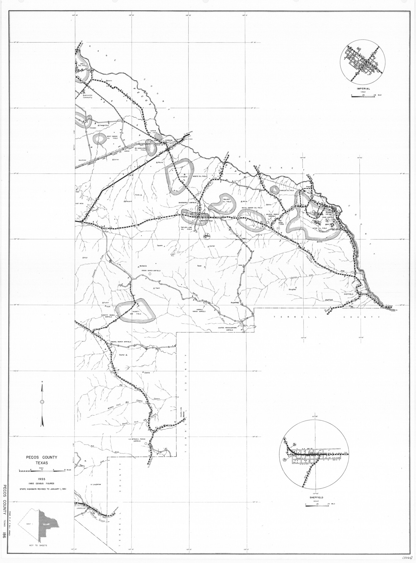
General Highway Map, Pecos County, Texas
-
Map/Doc
79628
-
Collection
Texas State Library and Archives
-
Object Dates
1961 (Creation Date)
-
People and Organizations
Texas State Highway Department (Publisher)
-
Counties
Pecos
-
Subjects
County
-
Height x Width
24.6 x 18.2 inches
62.5 x 46.2 cm
-
Comments
Prints available courtesy of the Texas State Library and Archives.
More info can be found here: TSLAC Map 05266
Part of: Texas State Library and Archives
General Highway Map. Detail of Cities and Towns in Bell County, Texas [Killeen and Holland, etc.]
![79367, General Highway Map. Detail of Cities and Towns in Bell County, Texas [Killeen and Holland, etc.], Texas State Library and Archives](https://historictexasmaps.com/wmedia_w700/maps/79367.tif.jpg)
Print $20.00
General Highway Map. Detail of Cities and Towns in Bell County, Texas [Killeen and Holland, etc.]
1961
Size 18.2 x 25.0 inches
Map/Doc 79367
General Highway Map, Brewster County, Texas

Print $20.00
General Highway Map, Brewster County, Texas
1961
Size 18.3 x 24.9 inches
Map/Doc 79386
Map of Texas, compiled from surveys on record in the General Land Office of the Republic

Print $20.00
Map of Texas, compiled from surveys on record in the General Land Office of the Republic
1847
Size 32.2 x 25.0 inches
Map/Doc 79325
Map of Texas to Accompany Granger's Southern and Western Texas Guide

Print $20.00
Map of Texas to Accompany Granger's Southern and Western Texas Guide
1878
Size 26.4 x 20.4 inches
Map/Doc 76235
General Highway Map, Scurry County, Texas

Print $20.00
General Highway Map, Scurry County, Texas
1961
Size 18.1 x 24.8 inches
Map/Doc 79650
General Highway Map, Cherokee County, Texas

Print $20.00
General Highway Map, Cherokee County, Texas
1961
Size 18.2 x 24.7 inches
Map/Doc 79406
General Highway Map, Deaf Smith County, Texas

Print $20.00
General Highway Map, Deaf Smith County, Texas
1961
Size 25.0 x 18.3 inches
Map/Doc 79438
General Highway Map, Parker County, Texas

Print $20.00
General Highway Map, Parker County, Texas
1961
Size 18.3 x 24.5 inches
Map/Doc 79625
Map of the City of Galveston, situated on the East End of Galveston Island, Texas

Print $20.00
Map of the City of Galveston, situated on the East End of Galveston Island, Texas
1869
Size 33.3 x 46.6 inches
Map/Doc 76186
[Plat of Victoria, Texas]
![76270, [Plat of Victoria, Texas], Texas State Library and Archives](https://historictexasmaps.com/wmedia_w700/maps/76270.tif.jpg)
Print $20.00
[Plat of Victoria, Texas]
1850
Size 14.1 x 11.5 inches
Map/Doc 76270
General Highway Map, Pecos County, Texas

Print $20.00
General Highway Map, Pecos County, Texas
1940
Size 24.7 x 18.1 inches
Map/Doc 79218
General Highway Map. Detail of Cities and Towns in Travis County, Texas. City Map, Austin and vicinity, Travis County, Texas

Print $20.00
General Highway Map. Detail of Cities and Towns in Travis County, Texas. City Map, Austin and vicinity, Travis County, Texas
1961
Size 18.2 x 24.9 inches
Map/Doc 79684
You may also like
San Saba County Working Sketch 4

Print $20.00
- Digital $50.00
San Saba County Working Sketch 4
1941
Size 43.4 x 31.8 inches
Map/Doc 63792
Galveston Bay and Approaches

Print $20.00
- Digital $50.00
Galveston Bay and Approaches
1957
Size 43.6 x 32.7 inches
Map/Doc 69877
Kendall County Working Sketch 15

Print $20.00
- Digital $50.00
Kendall County Working Sketch 15
1967
Size 41.4 x 40.7 inches
Map/Doc 66687
Llano County Working Sketch 9

Print $20.00
- Digital $50.00
Llano County Working Sketch 9
1979
Size 33.4 x 24.0 inches
Map/Doc 70627
C No. 2 - Preliminary Sketch of Chincoteague Inlet and Shoals in the Vicinity - Sea Coast of Virginia

Print $20.00
- Digital $50.00
C No. 2 - Preliminary Sketch of Chincoteague Inlet and Shoals in the Vicinity - Sea Coast of Virginia
1852
Size 16.5 x 19.4 inches
Map/Doc 97206
Hood County Sketch File 6

Print $4.00
- Digital $50.00
Hood County Sketch File 6
Size 7.2 x 6.1 inches
Map/Doc 26579
Morris County Working Sketch 4

Print $20.00
- Digital $50.00
Morris County Working Sketch 4
1959
Size 35.2 x 23.8 inches
Map/Doc 71203
Location of the Southern Kansas Railway of Texas, Carson County, Texas

Print $40.00
- Digital $50.00
Location of the Southern Kansas Railway of Texas, Carson County, Texas
1887
Size 20.5 x 84.3 inches
Map/Doc 64035
Jack County Working Sketch 6

Print $20.00
- Digital $50.00
Jack County Working Sketch 6
1952
Size 29.1 x 24.3 inches
Map/Doc 66432
Dickens County Sketch File N

Print $4.00
- Digital $50.00
Dickens County Sketch File N
1903
Size 8.3 x 13.6 inches
Map/Doc 20942
La Salle County Working Sketch 47

Print $20.00
- Digital $50.00
La Salle County Working Sketch 47
1982
Size 20.3 x 20.5 inches
Map/Doc 70348
Crosby County Working Sketch 4

Print $20.00
- Digital $50.00
Crosby County Working Sketch 4
1907
Size 19.9 x 14.0 inches
Map/Doc 68438