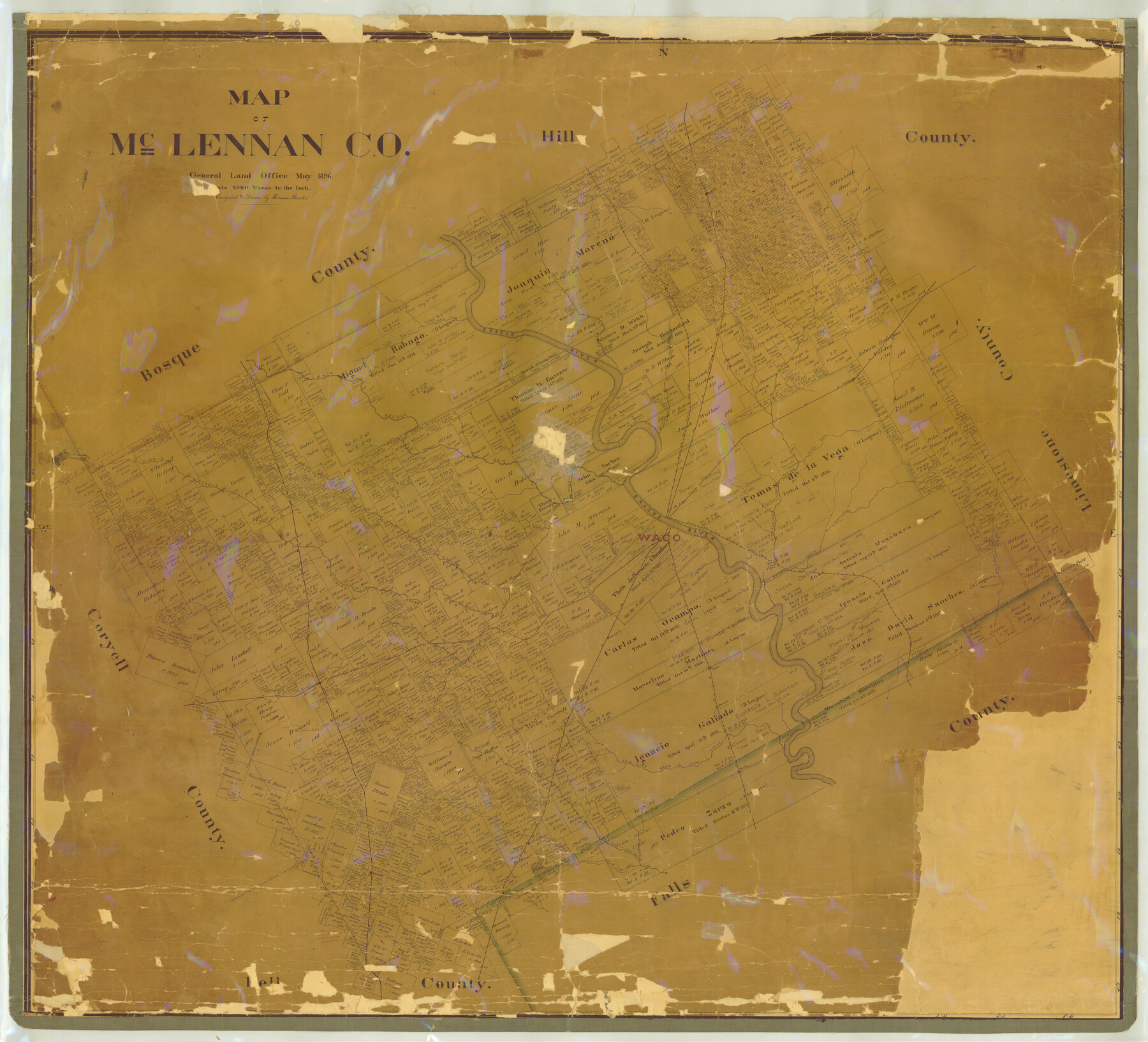
Map of McLennan County
-
Map/Doc
7952
-
Collection
General Map Collection
-
Object Dates
1896 (Creation Date)
-
People and Organizations
Texas General Land Office (Publisher)
Herman Pressler (Compiler)
Herman Pressler (Draftsman)
-
Counties
McLennan
-
Subjects
County
-
Height x Width
48.8 x 53.7 inches
124.0 x 136.4 cm
-
Comments
Help Save Texas History - Adopt Me!
-
Features
Crawford
Hewitt
Downs
Manas Creek
Turtle Bayou
Riesel
Big Creek
Harrison
Shaw's Creek
Sheep-Range Creek
Bluff Creek
Waco
Trading-House Creek
South Fork of Tehuacana Creek
Tehuacana Creek
W&NW
Farr
Patton
Moody
McGregor
Hoolie Br[anch]
Eddy
Cottonwood Creek
Cow Bayou
North Fork of Cow Bayou
South Fork of Cow Bayou
Bruceville
Middle Bosque River
Corrset County Line
Lorena
Gurly
Lake Creek
Bull Hide Bear Creek
Norwood
South Bosque River
Bull Hide Creek
Gholson
Brazos River
Childress Creek
North Fork of Childress Creek
South Fork of Childress Creek
West
Bruceville
Bear Creek
Aquila
Bluff Creek
Crawford
Waco Creek
Big Creek
China Springs
Axtell
Cottonwood Creek
Aquila Creek
Gerald
Hog Creek
Bosque River
Main Bosque River
China Springs
Patrick
Otter Creek
Axtell
Cottonwood Creek
Brazos River
GC&SF
H&TC
SL&SW
MK&T
Geneva
White Oak Creek
Ross
Part of: General Map Collection
Donley County Sketch File B8

Print $20.00
- Digital $50.00
Donley County Sketch File B8
1920
Size 15.3 x 15.9 inches
Map/Doc 11378
Harris County Working Sketch 99

Print $20.00
- Digital $50.00
Harris County Working Sketch 99
1979
Size 46.6 x 30.1 inches
Map/Doc 65991
Texas Department of Corrections Prison Unit Locations

Print $20.00
- Digital $50.00
Texas Department of Corrections Prison Unit Locations
1960
Size 37.0 x 45.7 inches
Map/Doc 3104
Flight Mission No. CRC-3R, Frame 16, Chambers County

Print $20.00
- Digital $50.00
Flight Mission No. CRC-3R, Frame 16, Chambers County
1956
Size 18.6 x 22.2 inches
Map/Doc 84790
Foard County Working Sketch 12

Print $20.00
- Digital $50.00
Foard County Working Sketch 12
1977
Size 43.4 x 36.1 inches
Map/Doc 69203
San Jacinto County Working Sketch 40

Print $40.00
- Digital $50.00
San Jacinto County Working Sketch 40
1971
Size 43.9 x 59.8 inches
Map/Doc 63753
United States - Gulf Coast Texas - Southern part of Laguna Madre

Print $20.00
- Digital $50.00
United States - Gulf Coast Texas - Southern part of Laguna Madre
1933
Size 26.9 x 18.3 inches
Map/Doc 72952
Henderson County Working Sketch 39

Print $20.00
- Digital $50.00
Henderson County Working Sketch 39
1982
Size 24.3 x 19.0 inches
Map/Doc 66172
Intracoastal Waterway in Texas - Corpus Christi to Point Isabel including Arroyo Colorado to Mo. Pac. R.R. Bridge Near Harlingen

Print $20.00
- Digital $50.00
Intracoastal Waterway in Texas - Corpus Christi to Point Isabel including Arroyo Colorado to Mo. Pac. R.R. Bridge Near Harlingen
1933
Size 27.7 x 41.0 inches
Map/Doc 61857
Archer County Sketch File 8b

Print $42.00
- Digital $50.00
Archer County Sketch File 8b
1890
Map/Doc 88497
Flight Mission No. CRC-3R, Frame 208, Chambers County

Print $20.00
- Digital $50.00
Flight Mission No. CRC-3R, Frame 208, Chambers County
1956
Size 18.6 x 22.3 inches
Map/Doc 84863
Sherman County Sketch File B

Print $6.00
- Digital $50.00
Sherman County Sketch File B
1919
Size 14.4 x 8.8 inches
Map/Doc 36691
You may also like
Crockett County Rolled Sketch 68

Print $20.00
- Digital $50.00
Crockett County Rolled Sketch 68
1947
Size 25.8 x 38.7 inches
Map/Doc 5611
El Paso County Rolled Sketch 54

Print $20.00
- Digital $50.00
El Paso County Rolled Sketch 54
1980
Size 30.4 x 42.8 inches
Map/Doc 44539
The Chief Justice County of Jasper. Lands in Conflict with Sabine County

Print $20.00
The Chief Justice County of Jasper. Lands in Conflict with Sabine County
2020
Size 18.3 x 21.7 inches
Map/Doc 96053
Nueces County Sketch File 49

Print $20.00
- Digital $50.00
Nueces County Sketch File 49
1956
Size 32.4 x 17.1 inches
Map/Doc 42193
Texas-Oklahoma Boundary Line: brief summary of the lands surveyed and the lands not surveyed in the dispute between Oklahoma vs. Texas

Print $356.00
- Digital $50.00
Texas-Oklahoma Boundary Line: brief summary of the lands surveyed and the lands not surveyed in the dispute between Oklahoma vs. Texas
1923
Size 6.0 x 9.2 inches
Map/Doc 3061
Floyd County Boundary File 1

Print $30.00
- Digital $50.00
Floyd County Boundary File 1
Size 8.9 x 4.2 inches
Map/Doc 53445
[Sketch of area just south of Levi Pruitt survey]
![91854, [Sketch of area just south of Levi Pruitt survey], Twichell Survey Records](https://historictexasmaps.com/wmedia_w700/maps/91854-1.tif.jpg)
Print $20.00
- Digital $50.00
[Sketch of area just south of Levi Pruitt survey]
Size 24.9 x 18.6 inches
Map/Doc 91854
Galveston County NRC Article 33.136 Sketch 19

Print $50.00
- Digital $50.00
Galveston County NRC Article 33.136 Sketch 19
2002
Size 37.1 x 25.4 inches
Map/Doc 78491
University Land Field Note Volume Index

University Land Field Note Volume Index
2023
Size 8.5 x 11.0 inches
Map/Doc 97177
United States Population Distribution by County and Territory, per the U.S. Census of 1900

United States Population Distribution by County and Territory, per the U.S. Census of 1900
2025
Size 8.5 x 11.0 inches
Map/Doc 97481
Upshur County Sketch File 18

Print $39.00
- Digital $50.00
Upshur County Sketch File 18
Size 11.4 x 8.9 inches
Map/Doc 38773
Dallas County Working Sketch 11

Print $20.00
- Digital $50.00
Dallas County Working Sketch 11
1982
Size 32.2 x 23.1 inches
Map/Doc 68577