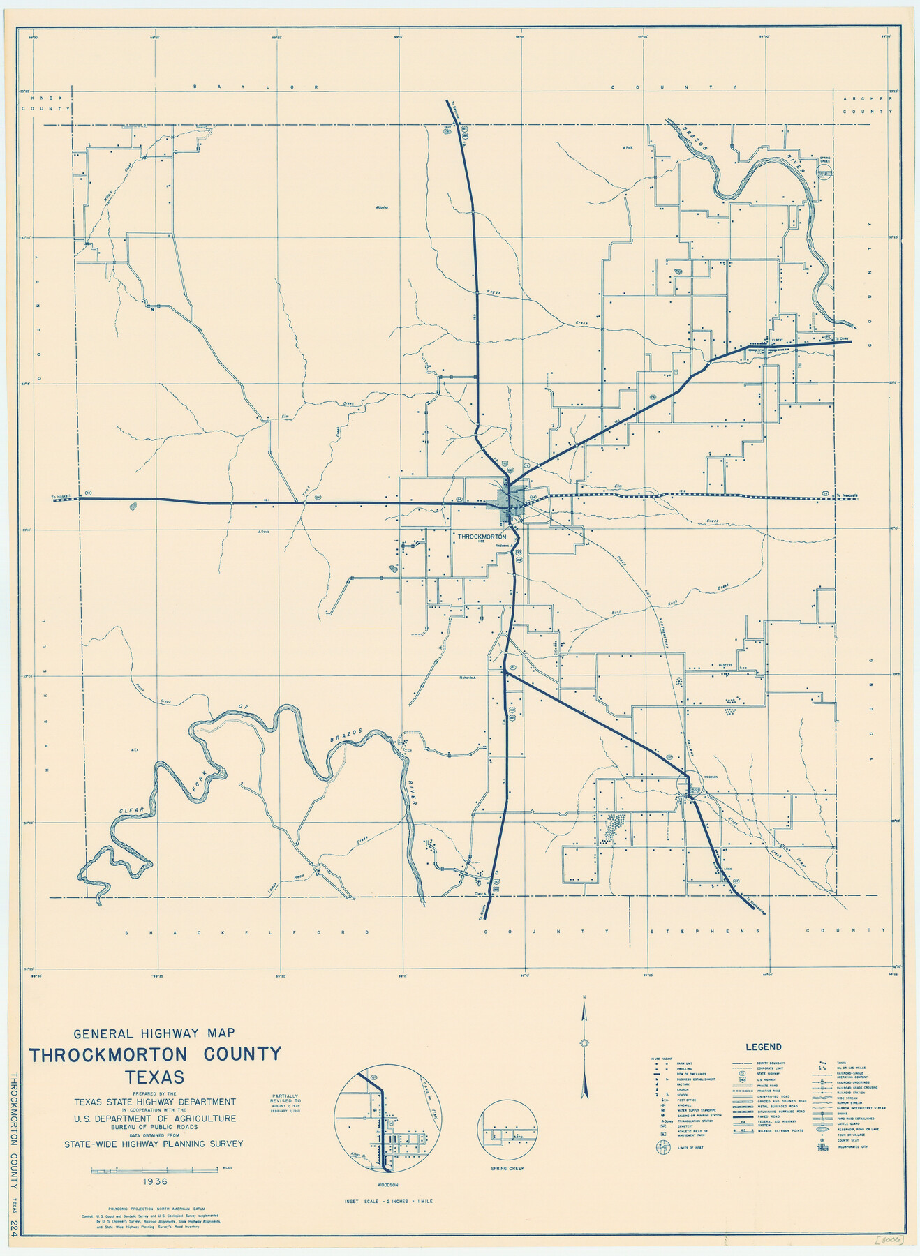
General Highway Map, Throckmorton County, Texas
-
Map/Doc
79258
-
Collection
Texas State Library and Archives
-
Object Dates
1940 (Creation Date)
-
People and Organizations
Texas State Highway Department (Publisher)
-
Counties
Throckmorton
-
Subjects
County
-
Height x Width
24.9 x 18.2 inches
63.3 x 46.2 cm
-
Comments
Prints available courtesy of the Texas State Library and Archives.
More info can be found here: TSLAC Map 05006
Part of: Texas State Library and Archives
General Highway Map, Cherokee County, Texas

Print $20.00
General Highway Map, Cherokee County, Texas
1961
Size 18.2 x 24.6 inches
Map/Doc 79405
General Highway Map, Kinney County, Uvalde County, Texas

Print $20.00
General Highway Map, Kinney County, Uvalde County, Texas
1940
Size 18.4 x 24.8 inches
Map/Doc 79162
General Highway Map. Detail of Cities and Towns in Nacogdoches County, Texas

Print $20.00
General Highway Map. Detail of Cities and Towns in Nacogdoches County, Texas
1961
Size 19.3 x 25.0 inches
Map/Doc 79608
Military Map of Western Texas

Print $20.00
Military Map of Western Texas
1884
Size 24.1 x 38.2 inches
Map/Doc 76315
General Highway Map, Knox County, Texas

Print $20.00
General Highway Map, Knox County, Texas
1940
Size 18.3 x 24.8 inches
Map/Doc 79166
General Highway Map, Goliad County, Texas

Print $20.00
General Highway Map, Goliad County, Texas
1940
Size 18.7 x 25.1 inches
Map/Doc 79101
General Highway Map. Detail of Cities and Towns in Tarrant County, Texas [Fort Worth and vicinity]
![79253, General Highway Map. Detail of Cities and Towns in Tarrant County, Texas [Fort Worth and vicinity], Texas State Library and Archives](https://historictexasmaps.com/wmedia_w700/maps/79253-GC.tif.jpg)
Print $20.00
General Highway Map. Detail of Cities and Towns in Tarrant County, Texas [Fort Worth and vicinity]
1940
Size 24.8 x 18.4 inches
Map/Doc 79253
Mitchell's Travellers Guide Through the United States. A Map of the Roads, Distances, Steam Boat, and Canal Routes etc.

Print $20.00
Mitchell's Travellers Guide Through the United States. A Map of the Roads, Distances, Steam Boat, and Canal Routes etc.
1835
Size 18.0 x 22.7 inches
Map/Doc 79723
Oil and Gas Fields in the State of Texas

Print $40.00
Oil and Gas Fields in the State of Texas
1927
Size 58.2 x 38.1 inches
Map/Doc 76303
General Highway Map, Fayette County, Texas

Print $20.00
General Highway Map, Fayette County, Texas
1940
Size 18.5 x 25.0 inches
Map/Doc 79089
General Highway Map, Reeves County, Texas

Print $20.00
General Highway Map, Reeves County, Texas
1961
Size 24.6 x 18.2 inches
Map/Doc 79638
General Highway Map, Terrell County, Texas

Print $20.00
General Highway Map, Terrell County, Texas
1940
Size 24.9 x 18.4 inches
Map/Doc 79256
You may also like
Parker County Sketch File 23

Print $20.00
- Digital $50.00
Parker County Sketch File 23
1876
Size 18.8 x 22.8 inches
Map/Doc 12145
Terry County Working Sketch 4

Print $20.00
- Digital $50.00
Terry County Working Sketch 4
Size 24.9 x 29.6 inches
Map/Doc 62109

Maps of Gulf Intracoastal Waterway, Texas - Sabine River to the Rio Grande and connecting waterways including ship channels

Print $20.00
- Digital $50.00
Maps of Gulf Intracoastal Waterway, Texas - Sabine River to the Rio Grande and connecting waterways including ship channels
1966
Size 14.7 x 21.0 inches
Map/Doc 61992
[Sketch for Mineral Application 24072, San Jacinto River]
![65603, [Sketch for Mineral Application 24072, San Jacinto River], General Map Collection](https://historictexasmaps.com/wmedia_w700/maps/65603.tif.jpg)
Print $20.00
- Digital $50.00
[Sketch for Mineral Application 24072, San Jacinto River]
1929
Size 23.4 x 17.6 inches
Map/Doc 65603
Cameron County Sketch File 7a

Print $32.00
- Digital $50.00
Cameron County Sketch File 7a
1982
Size 11.2 x 8.4 inches
Map/Doc 17115
[Maps of surveys in Reeves & Culberson Cos]
![61129, [Maps of surveys in Reeves & Culberson Cos], General Map Collection](https://historictexasmaps.com/wmedia_w700/maps/61129.tif.jpg)
Print $20.00
- Digital $50.00
[Maps of surveys in Reeves & Culberson Cos]
1937
Size 30.7 x 25.0 inches
Map/Doc 61129
![91965, [PSL Block B19], Twichell Survey Records](https://historictexasmaps.com/wmedia_w700/maps/91965-1.tif.jpg)
Gaines County Working Sketch 21

Print $20.00
- Digital $50.00
Gaines County Working Sketch 21
1970
Size 37.8 x 45.4 inches
Map/Doc 69321
Titus County Sketch File 14

Print $4.00
- Digital $50.00
Titus County Sketch File 14
Size 9.7 x 8.3 inches
Map/Doc 38157
Somervell County Working Sketch 1

Print $20.00
- Digital $50.00
Somervell County Working Sketch 1
1950
Size 17.8 x 15.4 inches
Map/Doc 63905
Coast Chart No. 210 Aransas Pass and Corpus Christi Bay with the coast to latitude 27° 12' Texas

Print $20.00
- Digital $50.00
Coast Chart No. 210 Aransas Pass and Corpus Christi Bay with the coast to latitude 27° 12' Texas
1913
Size 27.9 x 18.3 inches
Map/Doc 72805