Taylor County Rolled Sketch 24
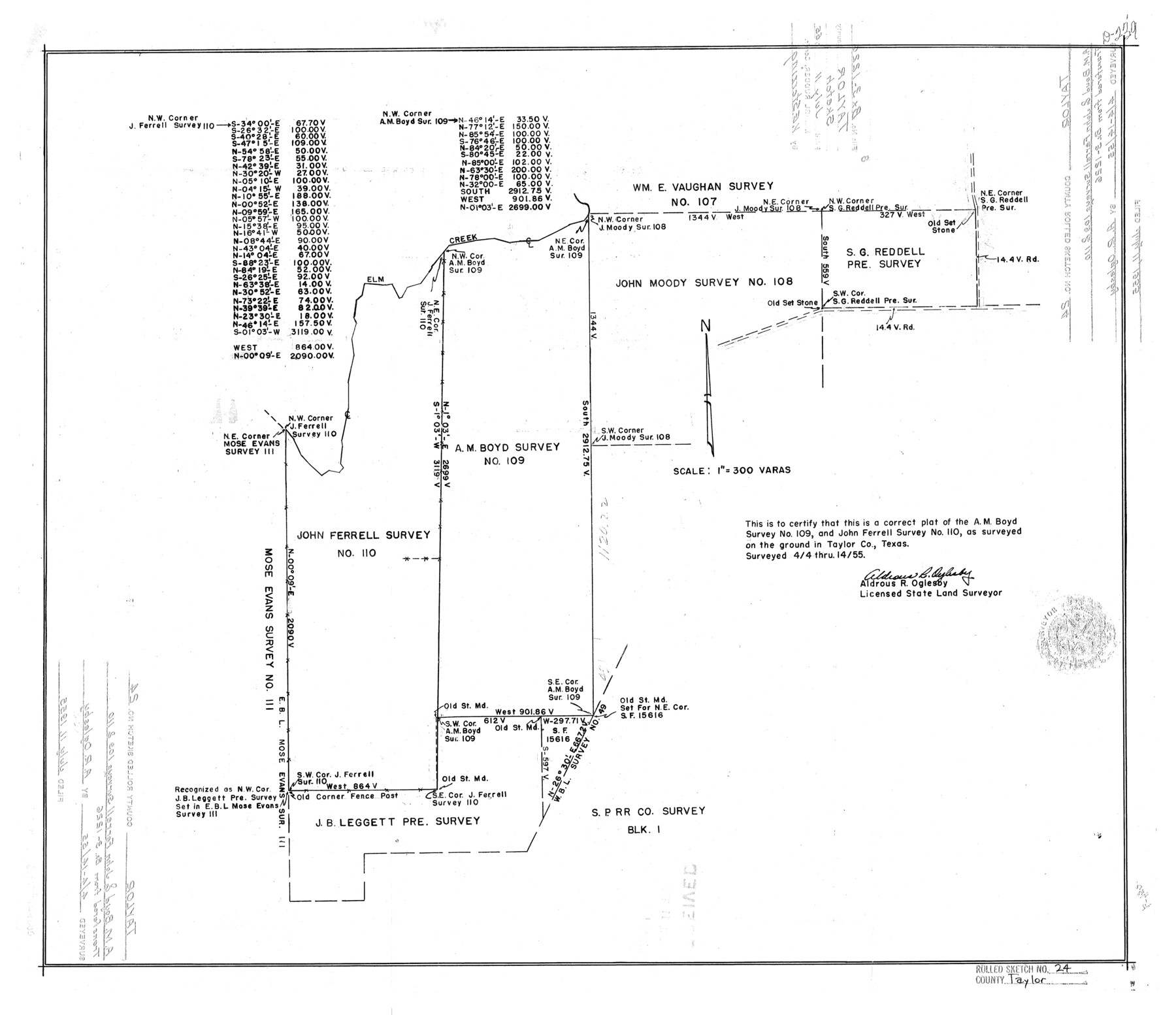
[Plat of A.M. Boyd survey no. 109 and John Ferrell survey no. 110]
-
Map/Doc
7916
-
Collection
General Map Collection
-
Object Dates
1955/4/14 (Survey Date)
1955/7/11 (File Date)
-
People and Organizations
Aldrous R. Oglesby (Surveyor/Engineer)
-
Counties
Taylor
-
Subjects
Surveying Rolled Sketch
-
Height x Width
19.6 x 22.7 inches
49.8 x 57.7 cm
-
Scale
1" = 300 varas
Part of: General Map Collection
The Military History of Texas Map!

The Military History of Texas Map!
Size 24.2 x 35.2 inches
Map/Doc 94360
Jeff Davis County Sketch File 45

Print $10.00
- Digital $50.00
Jeff Davis County Sketch File 45
1890
Size 14.0 x 8.5 inches
Map/Doc 28075
Stonewall County Rolled Sketch 15

Print $20.00
- Digital $50.00
Stonewall County Rolled Sketch 15
1902
Size 39.2 x 28.0 inches
Map/Doc 7870
Flight Mission No. DQO-3K, Frame 26, Galveston County

Print $20.00
- Digital $50.00
Flight Mission No. DQO-3K, Frame 26, Galveston County
1952
Size 17.4 x 18.9 inches
Map/Doc 85067
Brewster County Sketch File N-22

Print $40.00
- Digital $50.00
Brewster County Sketch File N-22
Size 12.4 x 21.4 inches
Map/Doc 10969
Map of north end of Brazos Island

Print $20.00
- Digital $50.00
Map of north end of Brazos Island
Size 27.5 x 18.3 inches
Map/Doc 72906
Galveston County NRC Article 33.136 Sketch 85

Print $42.00
- Digital $50.00
Galveston County NRC Article 33.136 Sketch 85
2015
Size 36.4 x 24.5 inches
Map/Doc 94965
Flight Mission No. BRA-6M, Frame 80, Jefferson County

Print $20.00
- Digital $50.00
Flight Mission No. BRA-6M, Frame 80, Jefferson County
1953
Size 18.6 x 22.3 inches
Map/Doc 85424
Flight Mission No. DQO-2K, Frame 160, Galveston County

Print $20.00
- Digital $50.00
Flight Mission No. DQO-2K, Frame 160, Galveston County
1952
Size 18.7 x 22.4 inches
Map/Doc 85049


You may also like
Comanche County Working Sketch 31

Print $20.00
- Digital $50.00
Comanche County Working Sketch 31
1991
Size 28.4 x 24.2 inches
Map/Doc 68165
Brewster County Rolled Sketch 155

Print $20.00
- Digital $50.00
Brewster County Rolled Sketch 155
Size 36.8 x 24.7 inches
Map/Doc 78343
Caldwell County Working Sketch 10

Print $40.00
- Digital $50.00
Caldwell County Working Sketch 10
1977
Size 46.2 x 50.5 inches
Map/Doc 67840
Waller County Boundary File 1

Print $8.00
- Digital $50.00
Waller County Boundary File 1
Size 11.4 x 8.9 inches
Map/Doc 59663
[Map of Connecting Lines along or near the Red River]
![75546, [Map of Connecting Lines along or near the Red River], General Map Collection](https://historictexasmaps.com/wmedia_w700/maps/75546.tif.jpg)
Print $20.00
- Digital $50.00
[Map of Connecting Lines along or near the Red River]
Size 28.6 x 37.0 inches
Map/Doc 75546
Crane County Sketch File 23

Print $20.00
- Digital $50.00
Crane County Sketch File 23
1931
Size 21.3 x 39.1 inches
Map/Doc 11211
Terrell County Working Sketch 41

Print $20.00
- Digital $50.00
Terrell County Working Sketch 41
1957
Size 29.1 x 38.2 inches
Map/Doc 62134
Dawson County Sketch File 11

Print $20.00
- Digital $50.00
Dawson County Sketch File 11
1927
Size 18.6 x 20.9 inches
Map/Doc 11293
Map of the Texas & Pacific Railway and connections

Print $20.00
- Digital $50.00
Map of the Texas & Pacific Railway and connections
1903
Size 17.9 x 36.6 inches
Map/Doc 95767
Tarrant County Working Sketch 7

Print $40.00
- Digital $50.00
Tarrant County Working Sketch 7
1981
Size 18.9 x 54.3 inches
Map/Doc 62424
Clarkson's City Map of Port Aransas

Print $20.00
- Digital $50.00
Clarkson's City Map of Port Aransas
Size 18.5 x 26.7 inches
Map/Doc 3038
Fisher County Boundary File 3a

Print $20.00
- Digital $50.00
Fisher County Boundary File 3a
Size 25.1 x 26.0 inches
Map/Doc 53444