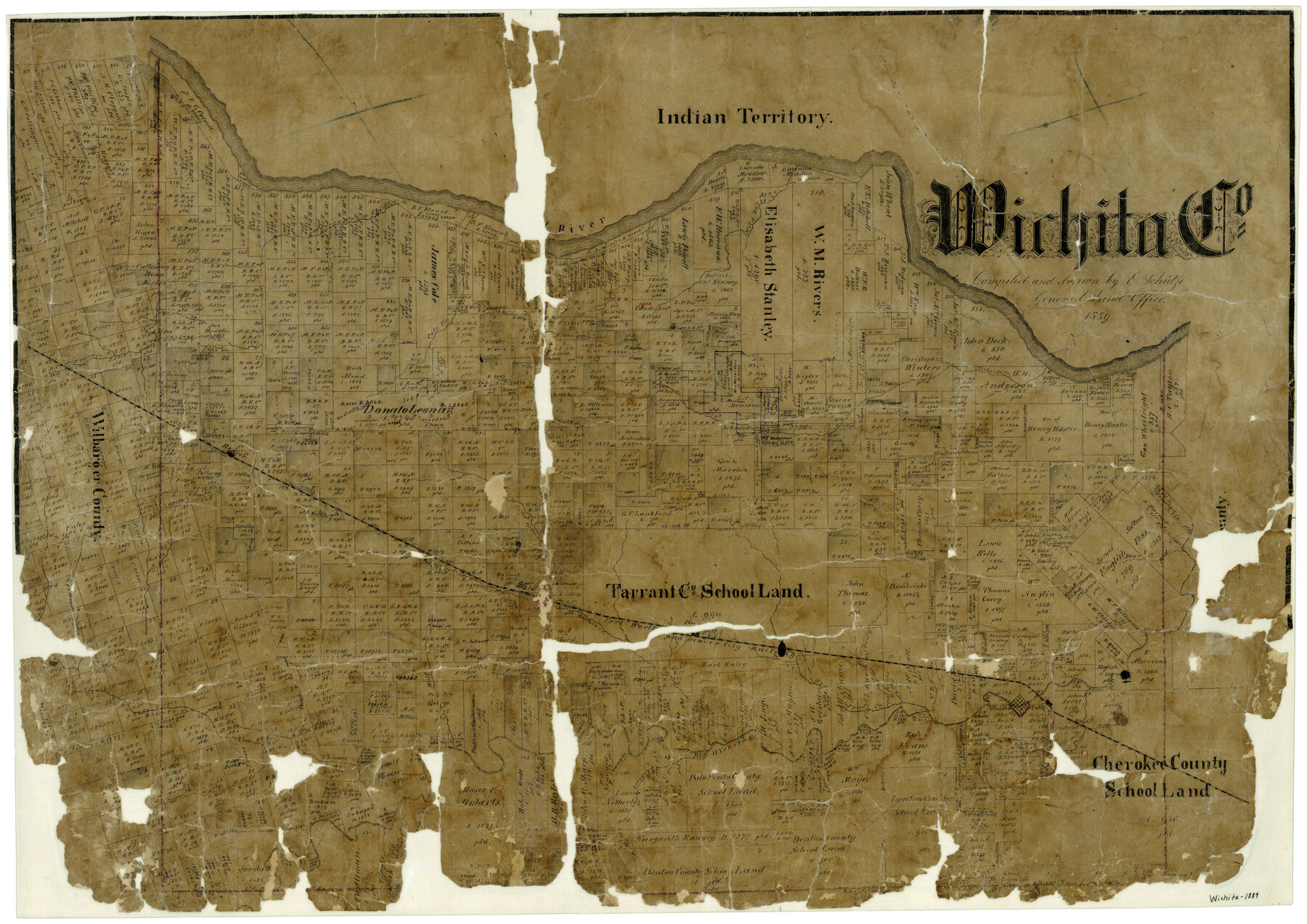
Wichita County
-
Map/Doc
4144
-
Collection
General Map Collection
-
Object Dates
1889 (Creation Date)
-
People and Organizations
Ed. Schutze (Draftsman)
-
Counties
Wichita
-
Subjects
County
-
Height x Width
26.8 x 37.4 inches
68.1 x 95.0 cm
-
Features
Plum Creek
Pond Creek
Gilbert's Creek
Red River
China Creek
Burk
Valley Creek
Holliday Creek
Big Wichita River
Lee's Creek
Camp Creek
Beaver Creek
Wolf Creek
West Pond Creek
Wichita Falls
Moores Creek
East Pond Creek
FW&DC
Buffalo Creek
Pale Creek
Burnett Creek
Bear Creek
Buffalo Head Creek
Beaver
Clara
Caney Creek
Cole Creek
West China Creek
Wild Horse Creek
Part of: General Map Collection
Day Ranch Lands, Leaday, Texas

Print $20.00
- Digital $50.00
Day Ranch Lands, Leaday, Texas
1948
Size 30.8 x 23.0 inches
Map/Doc 81516
Coryell County Working Sketch 32

Print $20.00
- Digital $50.00
Coryell County Working Sketch 32
2022
Size 25.3 x 36.9 inches
Map/Doc 96966
San Saba County Working Sketch 14

Print $20.00
- Digital $50.00
San Saba County Working Sketch 14
1998
Size 29.0 x 42.8 inches
Map/Doc 63802
Flight Mission No. BRE-2P, Frame 68, Nueces County

Print $20.00
- Digital $50.00
Flight Mission No. BRE-2P, Frame 68, Nueces County
1956
Size 18.6 x 22.4 inches
Map/Doc 86763

Jackson County Working Sketch 8

Print $20.00
- Digital $50.00
Jackson County Working Sketch 8
1980
Size 30.4 x 29.0 inches
Map/Doc 66456
Fractional Township No. 7 South Range No. 6 East of the Indian Meridian, Indian Territory

Print $20.00
- Digital $50.00
Fractional Township No. 7 South Range No. 6 East of the Indian Meridian, Indian Territory
1898
Size 19.2 x 24.3 inches
Map/Doc 75211
Briscoe County Sketch File 10

Print $4.00
- Digital $50.00
Briscoe County Sketch File 10
1901
Size 11.2 x 8.7 inches
Map/Doc 16420
Medina County Working Sketch Graphic Index

Print $40.00
- Digital $50.00
Medina County Working Sketch Graphic Index
1976
Size 52.8 x 42.8 inches
Map/Doc 76639

Llano County Boundary File 2

Print $30.00
- Digital $50.00
Llano County Boundary File 2
Size 14.3 x 8.8 inches
Map/Doc 56443
Flight Mission No. DQN-3K, Frame 67, Calhoun County

Print $20.00
- Digital $50.00
Flight Mission No. DQN-3K, Frame 67, Calhoun County
1953
Size 18.6 x 22.3 inches
Map/Doc 84358
You may also like
Platts [sic] of S. C. Robertson Surveys
![105, Platts [sic] of S. C. Robertson Surveys, General Map Collection](https://historictexasmaps.com/wmedia_w700/maps/105.tif.jpg)
Print $20.00
- Digital $50.00
Platts [sic] of S. C. Robertson Surveys
1841
Size 13.6 x 15.7 inches
Map/Doc 105
Young County Rolled Sketch 12

Print $20.00
- Digital $50.00
Young County Rolled Sketch 12
Size 24.2 x 17.9 inches
Map/Doc 8300
[West half of Deaf Smith County showing School Land Leagues]
![90612, [West half of Deaf Smith County showing School Land Leagues], Twichell Survey Records](https://historictexasmaps.com/wmedia_w700/maps/90612-1.tif.jpg)
Print $20.00
- Digital $50.00
[West half of Deaf Smith County showing School Land Leagues]
Size 31.4 x 18.3 inches
Map/Doc 90612
Colorado County Sketch File 13

Print $4.00
- Digital $50.00
Colorado County Sketch File 13
Size 12.5 x 8.3 inches
Map/Doc 18937
Hutchinson County Rolled Sketch 44-13

Print $20.00
- Digital $50.00
Hutchinson County Rolled Sketch 44-13
2002
Size 24.0 x 36.0 inches
Map/Doc 77549
Montgomery County

Print $20.00
- Digital $50.00
Montgomery County
1901
Size 42.8 x 45.9 inches
Map/Doc 10794
Harris County Working Sketch 54

Print $20.00
- Digital $50.00
Harris County Working Sketch 54
1950
Size 21.3 x 24.1 inches
Map/Doc 65946
[Section 2, Block 5, Dawson County, Texas]
![92617, [Section 2, Block 5, Dawson County, Texas], Twichell Survey Records](https://historictexasmaps.com/wmedia_w700/maps/92617-1.tif.jpg)
Print $2.00
- Digital $50.00
[Section 2, Block 5, Dawson County, Texas]
Size 9.2 x 12.3 inches
Map/Doc 92617
Flight Mission No. CUG-1P, Frame 20, Kleberg County

Print $20.00
- Digital $50.00
Flight Mission No. CUG-1P, Frame 20, Kleberg County
1956
Size 18.6 x 22.4 inches
Map/Doc 86110
Atascosa County Working Sketch 5

Print $3.00
- Digital $50.00
Atascosa County Working Sketch 5
1913
Size 10.9 x 11.3 inches
Map/Doc 67201
Jackson County

Print $20.00
- Digital $50.00
Jackson County
1920
Size 45.9 x 39.1 inches
Map/Doc 73191
Map of Yoakum County Texas

Print $20.00
- Digital $50.00
Map of Yoakum County Texas
1938
Size 21.0 x 26.8 inches
Map/Doc 92447