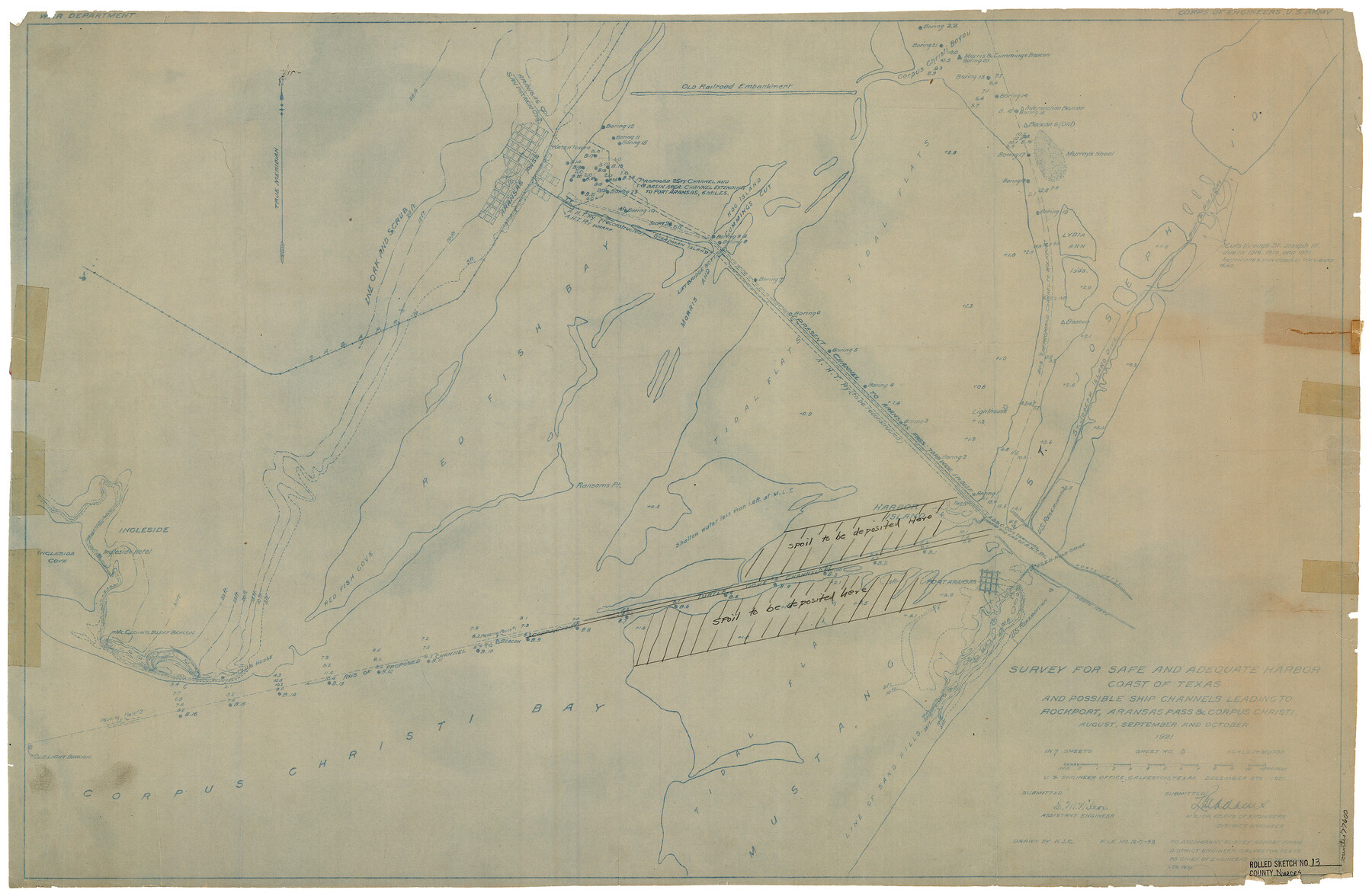
Nueces County Rolled Sketch 13
Survey for safe and adequate harbor coast of Texas and possible ship channels leading to Rockport, Aransas Pass & Corpus Christi
-
Map/Doc
77600
-
Collection
General Map Collection
-
Object Dates
12/11/1921 (Creation Date)
-
Counties
Nueces
-
Subjects
Surveying Rolled Sketch
-
Height x Width
21.6 x 32.0 inches
54.9 x 81.3 cm
-
Medium
blueprint/diazo
Part of: General Map Collection
Webb County Sketch File 13a

Print $20.00
- Digital $50.00
Webb County Sketch File 13a
1881
Size 19.0 x 25.7 inches
Map/Doc 12631
Howard County Rolled Sketch 11

Print $20.00
- Digital $50.00
Howard County Rolled Sketch 11
1940
Size 21.4 x 30.1 inches
Map/Doc 6242
Kinney County Rolled Sketch 14

Print $20.00
- Digital $50.00
Kinney County Rolled Sketch 14
1956
Size 19.5 x 25.8 inches
Map/Doc 6543
Colorado River, Willow Creek Valley Sheet[/Near Kirtley, Texas Mapped in Cooperation with Commissioner's Court of Fayette Co.]
![65322, Colorado River, Willow Creek Valley Sheet[/Near Kirtley, Texas Mapped in Cooperation with Commissioner's Court of Fayette Co.], General Map Collection](https://historictexasmaps.com/wmedia_w700/maps/65322.tif.jpg)
Print $20.00
- Digital $50.00
Colorado River, Willow Creek Valley Sheet[/Near Kirtley, Texas Mapped in Cooperation with Commissioner's Court of Fayette Co.]
1938
Size 38.2 x 40.8 inches
Map/Doc 65322
Hardin County Working Sketch 18

Print $20.00
- Digital $50.00
Hardin County Working Sketch 18
1944
Size 18.7 x 22.0 inches
Map/Doc 63416
Webb County Sketch File 14c

Print $20.00
- Digital $50.00
Webb County Sketch File 14c
1892
Size 20.5 x 13.0 inches
Map/Doc 12633
Travis County Rolled Sketch 44

Print $20.00
- Digital $50.00
Travis County Rolled Sketch 44
Size 34.2 x 35.6 inches
Map/Doc 10052
Kinney County Working Sketch 59

Print $20.00
- Digital $50.00
Kinney County Working Sketch 59
1999
Size 19.9 x 24.8 inches
Map/Doc 70241
Fort Bend County Sketch File 4

Print $4.00
- Digital $50.00
Fort Bend County Sketch File 4
1876
Size 10.0 x 8.4 inches
Map/Doc 22885
Map of Espiritu Santo Bay in Calhoun County showing subdivision therof for mineral development

Print $20.00
- Digital $50.00
Map of Espiritu Santo Bay in Calhoun County showing subdivision therof for mineral development
1938
Size 38.6 x 42.9 inches
Map/Doc 2499

Cottle County

Print $20.00
- Digital $50.00
Cottle County
1971
Size 43.4 x 36.0 inches
Map/Doc 95467
You may also like

La Salle County Sketch File 34

Print $6.00
- Digital $50.00
La Salle County Sketch File 34
Size 15.8 x 9.5 inches
Map/Doc 29585
Right of Way and Track Map, the Missouri, Kansas and Texas Ry. of Texas - Henrietta Division

Print $20.00
- Digital $50.00
Right of Way and Track Map, the Missouri, Kansas and Texas Ry. of Texas - Henrietta Division
1918
Size 11.8 x 26.8 inches
Map/Doc 64751
Flight Mission No. DCL-7C, Frame 115, Kenedy County

Print $20.00
- Digital $50.00
Flight Mission No. DCL-7C, Frame 115, Kenedy County
1943
Size 18.4 x 22.2 inches
Map/Doc 86080
Wilson Strickland Survey, Exhibit A

Print $20.00
- Digital $50.00
Wilson Strickland Survey, Exhibit A
Size 20.8 x 23.0 inches
Map/Doc 91368
Winkler County Sketch File 14

Print $20.00
- Digital $50.00
Winkler County Sketch File 14
Size 29.4 x 24.3 inches
Map/Doc 12698
General Highway Map, Mason County, Texas

Print $20.00
General Highway Map, Mason County, Texas
1961
Size 18.3 x 24.8 inches
Map/Doc 79584
Arlancy the Land of Plenty Farms

Print $20.00
- Digital $50.00
Arlancy the Land of Plenty Farms
1925
Size 10.8 x 16.6 inches
Map/Doc 96738
Matagorda Light to Aransas Pass

Print $20.00
- Digital $50.00
Matagorda Light to Aransas Pass
1961
Size 35.9 x 44.7 inches
Map/Doc 73396
[Highway Map of the State of Texas]
![5039, [Highway Map of the State of Texas], Maddox Collection](https://historictexasmaps.com/wmedia_w700/maps/5039-1.tif.jpg)
Print $20.00
- Digital $50.00
[Highway Map of the State of Texas]
1923
Size 44.7 x 46.7 inches
Map/Doc 5039
Anderson County Working Sketch 5

Print $20.00
- Digital $50.00
Anderson County Working Sketch 5
1913
Size 15.0 x 15.3 inches
Map/Doc 67004
Calhoun County Rolled Sketch 10

Print $20.00
- Digital $50.00
Calhoun County Rolled Sketch 10
Size 32.9 x 29.2 inches
Map/Doc 5366